0
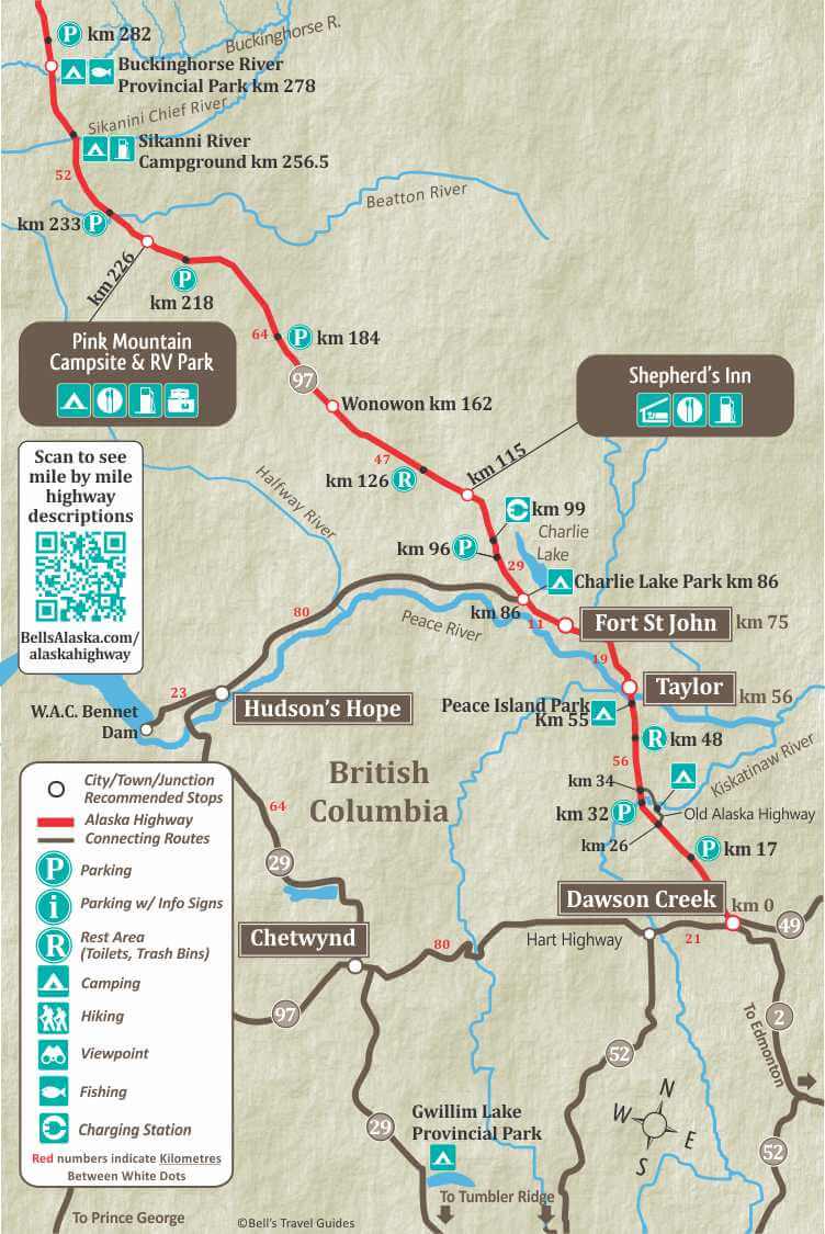
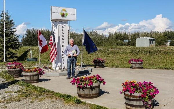
Dawson Creek is “Alaska Highway Mile 0” and has a population of approximately 11,000. Dawson Creek is also the end of the Hart Highway, which starts in Prince George. There is a commemorative Alaska Highway Mile 0 marker near the traffic Visitor Center. The Alaska Highway is 2,224 Km/1382 miles long to Delta Junction, Alaska. From Delta Junction it is another 98 miles to Fairbanks Alaska, on the Richardson Highway. For a complete list of Things to do in BC, the Yukon and Alaska on your trip north, visit our Things To Do section.
Dawson Creek Visitor Info Centre
Provides travel information on Dawson Creek, the Yukon and Alaska as well as Alberta and Northwest Territories. www.tourismdawsoncreek.com

2.4
Mile 0 RV Park, Walter Wright Pioneer Village.
52.8
Peace Island Provincial Park. Picnic tables and boat launch.
53.6
Peace River Bridge. 712 meters
56
(HM 36) Taylor
Population 1200. Gas, groceries, accommodations, post office, restaurants. Nestled on the banks of the majestic Peace River, Taylor offers a wide variety of recreation and amenities. A $40 million natural gas scrubbing plant & oil refinery are here at the beginning of a 700-mile natural gas pipeline which supplies Vancouver & western Washington.
Taylor Visitor Info Centre
On the left when heading north at 10316 100 St. Stop in and ask the staff for local recommendations for camping, hotels and things to do in Taylor. 250-789-9015
www.districtoftaylor.com/visitor-information-centre
75.6
(HM 48) Fort St. John
The largest city in the Peace River North region, and a transportation hub for the Peace. Oil and gas, forestry and agriculture are also important to the local economy. Ft. St. John is 75 kilometres from Alaska Highway Mile 0 in Dawson Creek.
Fort St John Visitor Info Centre
Whether it be camping, fishing, golfing, boating or hiking the energetic staff will help you discover all there is to do in and around the City. fortstjohn.ca/tourism
86
Junction with Highway 29. Access the town of Hudson’s Hope (80 km) and Chetwynd (144 km), (at the junction of the Hart Highway). You can also access the The 600-ft. high W.A.C. Bennet Dam across the Peace River valley which created the 640-square mile Williston Lake, the largest lake in BC.
86
Charlie Lake Provincial Park. Turn east on the paved loop road. 58 Sites, picnic tables, kitchen shelters, outhouses and RV dump station. Water and parbage containers. Camping fees.
115
The Shepherd’s Inn (HM 72) – Offering a complete breakfast, lunch and dinner menu and homemade baked goods. 24-hour motel. High speed Internet, gas, diesel and propane.
162
Wonowon (HM 101)
This small highway settlement is the gateway to a vast wilderness of mountains, rivers and lakes accessed by the Alaska Highway. Formerly known as “Blueberry,” Wonowon was the site of a traffic control gate during World War II.
226
Pink Mountian (HM 143)
256.5
Sikanni River Campground & RV Park offers access to riverside camping in serviced and unserviced sites. Some pull-though sites, Wi-fi, coin operated laundry, showers and playground. Regular gas available (no diesel or propane). Open May – Sept. 250-264-7703
278.4
Buckinghorse River, Provincial Park (HM 175)
Fee area, 33 camp sites, tables, toilets, drinking water. Swimming and fishing in river.
320
Rest Area with large parking area, litter barrels and toilets.
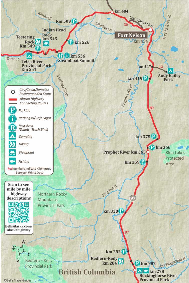
426.5
Andy Bailey Provincial Park, access by 12 km gravel road. Day-use area, 5 campsites, (not recommended for large vehicles) water, picnic tables, toilets, beach, swimming and boat launch. No turnaround area.
454
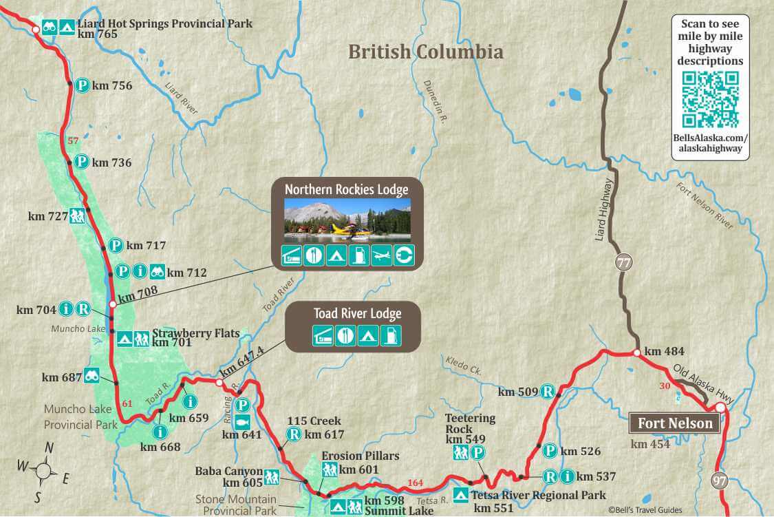
Fort Nelson Population 5,900, is a thriving community with an economy historically based on forestry, oil & gas, and an emerging tourism sector. Located 454 Kilometres from Dawson Creek.
Fort Nelson Visitor Info Centre
Stop by to pick up a free copy of the Northern Rockies Travel Guide or ask the travel advisors for more information about travel in Northern BC. www.tourismnorthernrockies.ca
483.5
Highway 77 Junction, Liard Highway to Fort Liard and the Mackenzie Highway to Fort Simpson. It is a good gravel highway. The highway was officially opened in June of 1984. Check current road conditions at the Visitor Info Centers in Fort Nelson BC or Fort Simpson, NWT. Gas is limited with facilities at Fort Liard at 170 km/105 miles and at 394 km/245 mile junction of MacKenzie Highway.
513.8
Muskwa River Park. Turn on Kledo Forest Service Road and drive to the end of the road. Boat Launch and picnic area. The road can be rough as it is not maintained.
536.6
Steamboat Mountain Summit. 3,500 ft. Rest area, toilets.
548.9
Parking off highway with large turn around area. Teetering Rock hiking Trail.
551
Tetsa River Regional Park, 2 km side road. 25 sites, water, toilets and firewood. Fishing for grayling & Dolly Varden, in the Tetsa River. Fee area.
597.7
Summit Lake (Stone Mountain) Provincial Campground, 28 camp sites, water, tables, boat launch, hiking trails. Fee area. Highest point on the Highway – 4,250 ft. Summit Peak trailhead
Flower Springs Trail starts just south of Summit Lake Campground. This trail takes hikers through lowland bogs and over glacial moraines, left from retreating glaciers, before reaching your destination at Flower Springs Lake. This is one of the most popular hikes in the region because it has amazing views and is moderately easy. It is 13.6 km round trip via the lake trail and 10.2 km round trip via the tower trail.
605.2
Baba Canyon trailhead. Trail is 5.5 km round trip to the first viewpoint, 11 km to the second.
614.4
Parking, access to Wokkpash Creek hiking trail, 15 km to Wokkpash Lake.
614.5
113 Creek and trailhead
616.5
115 Creek, wayside and rest area, tables, toilets, no drinking water.
647.4
Toad River Lodge. (HM 422). A brand new beautiful Lodge replaced the old lodge in 2021. Cabins with kitchenettes are available. A very nice RV park, that has full hookups, free satellite TV and Wi-fi. Excellent restaurant with home cooked meals. Service station with fuel & repairs.
658.6
Parking, information sign on geological formations of Folded Mountain. Tectonic deformations have folded the limestone giving these mountains their unique appearance
678.6
Peterson Creek named for Pete Peterson, a local trapper and big game guide, who came to the area in 1933. Pete Petersen was one of the few early white residents of the Muncho lake area and was instrumental in helping to refine the proposed route for the Army Core of Engineers. His story is mostly undocumented but he was a very well known trapper, guide and explorer. Many of the local landmarks bear his name such as Mt. Petersen overlooking Muncho Lake and Petersen Creek.
698
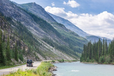
Muncho Lake
Driving along the shores of this massive jade green alpine lake is oddly reminiscent of Jasper National Park before the crowds. Muncho has a rich history, as it presented a considerable challenge during the original US Military construction of the highway. With the help of First Nations guide, Charlie McDonald, a safe route was plotted along the shoreline.
There are many small parking areas alongside Muncho Lake.
Muncho Lake Provincial Park has two campgrounds. Strawberry Flats, km 701, with 15 dry campsites. Easy access for small water craft such canoes, kayaks and SUPS. Water, picnic area and toilets. Macdonald Campground, km 710, has 15 dry campsites. Water, toilets, picnic area and boat launch.
701
Strawberry Flats Provincial Campground. 15 camp sites on the shore of Muncho Lake, tables, toilets. Old Alaska Hwy Trail & Viewpoint Trail starts from Strawberry flats Provincial Campground or 3km north (trailhead located along lakeshore). Hikers have an early climb as they ascend to the viewpoint trail but are soon rewarded with fantastic views of the lake below. The route is approximately 4 km long.
704.4
Rest area, stop of interest, information panels, wildlife viewing.
708
Northern Rockies Lodge & Adventures (HM 462). An impressive log building welcomes you to the resort on the shore of Muncho Lake. From cabins, with kitchenettes to an RV park with numerous amenities, the lodge is perfect for a multi day stay. For an unforgettable fly in fishing or floatplane tour join Northern Rockies adventure. EV-charging station, Regular & Premium fuel available. Open year-round.
709
MacDonald Campground. 15 camp sites on the shore of Muncho Lake, water, toilets. Fee area.
712.2
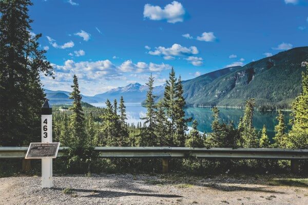
Viewpoint of Muncho Lake. Litter barrel. Information signs on the Muncho Lake and Alaska Highway Construction. Historic Mile Marker 463.
727
Hiking. There is a good chance you will see stone sheep in this area. Numerous natural mineral licks are found in the gullies near the highway.
763
Lower Liard River Bridge. This major northern river drains the eastern slopes of the Rocky Mountains and flows across the northern plain of British Columbia to empty into the Mackenzie River. The Liard, the Peace and Athabasca rivers, were natural water highway for the Fur Traders.
764.7
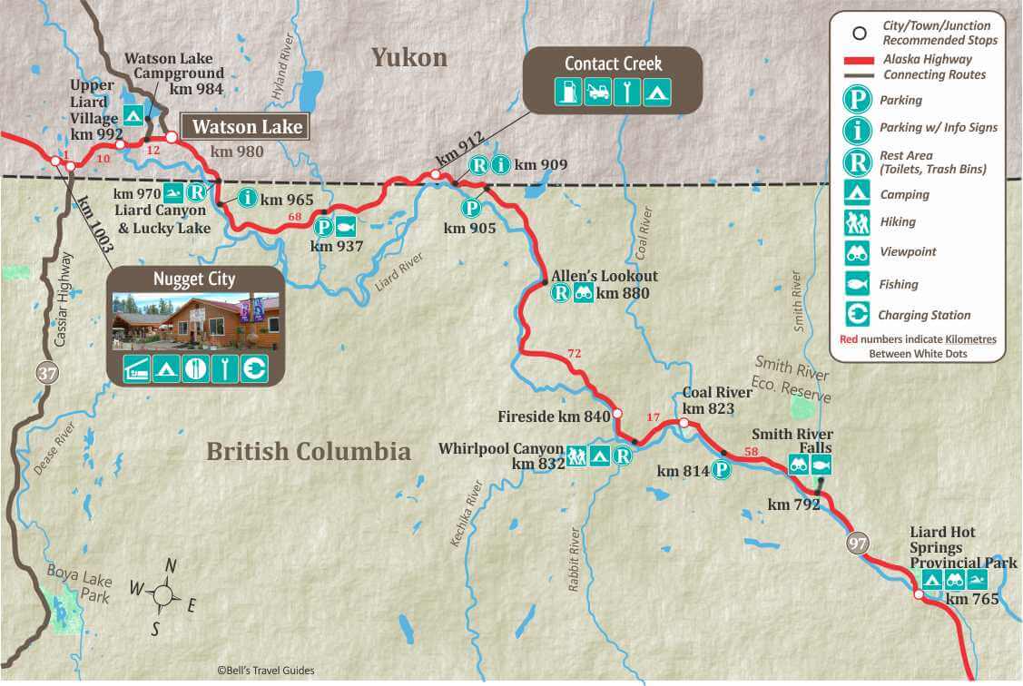
Liard River Hot Springs Provincial Park, water, toilets, firewood and day-use area. Natural hot springs, bathing pools, change houses at both pools, boardwalk connecting both pools, amphitheater, playground, horseshoe pits, wheelchair accessible. Enjoy a walk along the boardwalk to the mineral pools. This is a very busy park during the summer. Visitors are warned to watch for signs of bear and please don’t leave food out.
791.5
Smith River, large parking areas at both ends of bridge. Grayling, Dolly Varden. Smith River Falls, 1.5 mile gravel side road leads to viewpoint overlooking Smith River Falls. There is a good 1/4 mile trail to base of falls. Good turnaround area but will be tight if you are towing.
831.7
Whirlpool Canyon rest area. Limited turn around area. Camping, Short trail leads to Canyon.
880
Allen’s Lookout; large parking area with picnic tables, toilets.
905
Parking and Historic milepost 585 cairn
909.4
Contact Creek Rest area. Grayling and Dolly Varden. Sign about U.S. Army Engineers, some working southward, others northward, met here on September 24, 1942, marking completion of the highway. BC/Yukon Border, First Crossing. From here to official border crossing, highway crosses border 7 times.
912
Contact Creek Lodge (HM 590)
964.5
Parking with point of interest signs on the 68th Parrallel.
970.6
Rest Stop, toilets. Welcome to the Yukon sign. Access to Liard Canyon Recreation Site and Lucky Lake. Picnic area, waterslide, swimming, hiking and fishing.
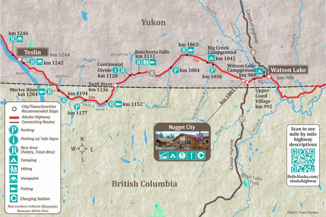
978
Watson Lake The first Yukon community encountered by the northbound traveler and the second largest town in the Yukon. It is a comfortable day’s drive from Fort Nelson or Whitehorse. For a complete list of Things to do in the Yukon and Alaska on your trip north, visit our Things To Do section.
Alaska Highway Interpretive Center
The center provides information as well as an exceptional display of photos, and other audiovisual presentations. www.travelyukon.com
980
Junction with the Robert Campbell Highway, which accesses the towns of Ross River and Faro. The Highway is 583km/362 miles and ends at the Klondike Highway, at Carmacks.
984
Watson Lake Government Campground, 4 km/3 miles access road, 55 camp sites, water, shelters, beach, boat launch, hiking trails, playground. Fee area.km 991.5/mile 616-Upper Liard River bridge. Fishing for grayling, Dolly Varden, lake trout, and northern pike in spring and fall.
1001.6
Junction of Cassiar Highway 37 and Alaska Highway (HM 649). The Cassiar Highway is a 724km/450 mile long highway that joins the BC towns of Kitwanga, Stewart, Dease Lake with the Alaska Highway. Junction 37 Services. Gas, diesel, propane, groceries, RV dump and water. 867-536-2794
1003
Nugget City. (HM 650)
Northern Beaver Post and Baby Nugget RV Park.
1003.6
Rest area with information map.
1042.1
Big Creek bridge. Big Creek wayside and rest area, day use area just north of bridge Toilets, kitchen shelters, tables, and water.
1042.2
Big Creek Campround. 15 camp sites, toilets, picnic tables, water pump. Fee area.
1063
Lower Rancheria River, rest area with toilets just south of bridge. Fishing for grayling and Dolly Varden. Use small black flies or spinners. Fishing is best in August.
1112.5
Rancheria Falls recreation site, large parking area, toilets. Well maintained trail and boardwalk lead to Rancheria River and Falls. 10-minute hike.
1120
Continental Divide rest area with toilets and information sign.
1136.7
Swift River Maintenance Camp (HM 733).
1152.1
Rest Area with scenic view. Swan Lake south of highway has Lake Trout and Whitefish. BC fishing license required. Toilets.
1204
Morley River Yukon Government Day-Use Area. Tables, toilets, kitchen shelter and water. Fly fishing for grayling.
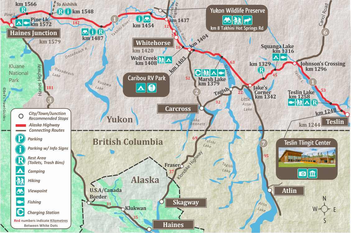
1242.7
Teslin Lake and Nisutlin Bay Bridge.
1243.5
Teslin. Population 125, is on the shores of Nisutlin Bay on Teslin Lake.
1243.6.
Nisutlin Trading Post Motel.
1246
Rest area by Teslin Lake
1248.1
The Teslin Tlingit Heritage Center.
1258
Teslin Lake Yukon government campground and Rest Area. 27 camp sites, fishing, swimming, hiking trails, boat launch. Fee area.
1258.1
Tenmile Creek. Rest area with toilets and litter barrels.
1295.7
Canol Road Junction (Yukon Highway 6). Side road leads 220 km/136 miles to the Campbell Hwy. 96 km/60 miles to campground at Quiet Lake (good fishing). No travel facilities between here and Ross River. This road parallels the $130-million Canada Oil pipeline which carried oil to Whitehorse over 600 miles from 60 producing wells near the Arctic Circle. Check road conditions locally.
1295.7
Johnson’s Crossing. Motel, RV park, Gas and Food
1316
Squanga Lake Yukon government campground, 16 camp sites. Fishing grayling, northern pike and whitefish is best from a small boat. Squanga is an Indian name for the whitefish that are found in the lake.Fee area.
1341.6
Jake’s Corner (HM 866). From this junction, Yukon Highway 8 leads 55 km/34 miles to Carcross, a goldrush town. From Carcross, the South Klondike Highway continues 105 km/65 miles to Skagway Alaska, most northerly stop on the Alaska Marine Highway System. Carcross can be visited as part of a “loop trip” which rejoins the Alaska Highway at km 1404. Yukon Highway 7 branches off at km 1.8 to Atlin, famous pioneer gold mining town.
1379
Marsh Lake Yukon government campground. 41 campsites, swimming beach, toilets, tables, kitchen shelter, playground, hiking trails, fishing-lake trout, grayling and northern pike.
1403
Caribou RV Park
1404.4
Junction with South Klondike Highway (Yukon Highway 2), access Carcross, and Skagway, Alaska
1408.2
Wolf Creek Yukon government campground, 40 camp sites, well water, toilets, tables, kitchen shelter, playground, hiking trails and fishing. Fee area.
1414.7
Side Road. One-half mile to Miles Canyon and suspension footbridge. Past the footbridge the road follows the shoreline of Schwatka Lake until, just past the hydro dam, it joins the main access route into Whitehorse. Caution: The road is narrow, winding and steep.
1415
GoNorth RV Services and RV Rentals.
Turn on Mt. Sima Road and follow for 1 km.
1417.9
Philmar Enterprises
1419
Information rest stop.
1419.4
Hi Country R.V. Park
1419.4
Whitehorse. South access to downtown via Robert Service Way. Whitehorse is The Capital of the Yukon and offers unparalleled access to the surrounding wilderness. Over two-thirds of the Yukon’s residents live in Whitehorse, which has a year-round population of about 36,000.
Yukon Visitor Reception Centre
This is a great place to start your visit to Whitehorse as there are many staff available to answer questions and tons of information on the surrounding areas.
https://yukon.ca/en/places/yukon-visitor-information-centre-whitehorse
1422.3
Yukon Transportation Museum. This is a very interesting stroll through the Yukon’s past. You will see the “Queen of the Yukon,” Lindbergh’s sister airship, as well as many other types of transportation that helped open the early Yukon to modern times.
1422.3
Beringia Interpretive Centre.
1423
Whitehorse Airport.
1425.5
Two Mile Hill Intersection, north access to downtown Whitehorse. Turn down the hill to access Whitehorse city center.
1426.9
Kopper King.
1454.1
Viewpoint overlooking the Takhini River. Parking. There is an information sign on the old Dawson Trail, the stagecoach trail between Whitehorse and Dawson City.
1487
Takhini Burn rest area. Litter barrels, outhouse and viewing platform with information signs on the 1958 Takhini wildfires.
1489.1
Side road to viewpoint 3.2 km/2 miles, Takhini River Campground 15 km, Kusawa Lake campground 23 km/14 miles, gravel road is narrow and winding, camp sites.
1547.5
Aishihik River, Rest Area at east end of Aishihik bridge with view of Canyon Creek Bridge, originally built in 1920 to haul supplies to Silver City, it was rebuilt in 1942 during construction of the Alaska Highway The bridge was typical of the type of construction used on the Alaska Highway. It was rebuilt again in 1987 and the Yukon government refurbished it in 2005.
Aishihik Lake Campground 42 km/26 miles, camp sites, shelter, fishing. Aishihik road leads 29 km/18 miles to Otter Falls day-use recreation site. Picnic tables, kitchen shelters and boat launch. There is fly fishing for lake trout, grayling and rainbow below the falls. 17 km/11 miles beyond the falls is the southern end of 40 mile-long Aishihik Lake with boat launch and fishing for lake trout, grayling and northern pike. The road (which is maintained only as far as Otter Falls) continues on to the abandoned First Nations village of Aishihik, 135 km/84 miles (and is not recommended for large RV’s).
1572.2
Pine Lake Public Campground. 42 camp sites, water, fire pits, shelters, swimming beach, excellent interpretive trial. Fishing and boating in nearby lake for lake trout, grayling, white fish, burbot and pike. Fee area.
1578
Da Ku Cultural Centre and Haines Junction Visitor Center. Includes Native cultural displays.
1578.5
Haines Junction. Population 800, this highway community is nestled at the base of the St. Elias Mountains and is the headquarters for Kluane National Park.
1596.7
Spruce Beetle Trail, Rest Area.
1598.6
Bear Creek Summit. 1,004 meters/3294 ft. Highest point on the highway between Whitehorse and Fairbanks.
1633
Boutillier Summit. 1,003 meters/3290 ft. Second highest point on the highway between Whitehorse and Fairbanks. If you are heading North this is your first glimpse of Kluane Lake.
1635.5
Rest area, interpretive sign on the Kluane Lake and First Nations history.
1635.8
Turn east on gravel road for 5 km/3 miles to ruins of Silver City. This old trading post, with roadhouse and North West Mounted Police barracks was on the wagon road from Whitehorse to the gold fields of Kluane Lake.
1642
Kluane Lake is 46 miles long is the largest lake in the Yukon. It is famed for its beauty and fishing. Huge waves are not uncommon on this lake, so if you are using a boat be careful and pay attention to the weather.
1642.1
Rest Area beside Kluane Lake.
1647.4
Slim’s River Bridge. Crosses ancient glacier moraine at head of Kluane Lake. Sheep Mountain, bordering highway is in Kluane National Park. Dall Sheep are often seen on hillside.
1648.9
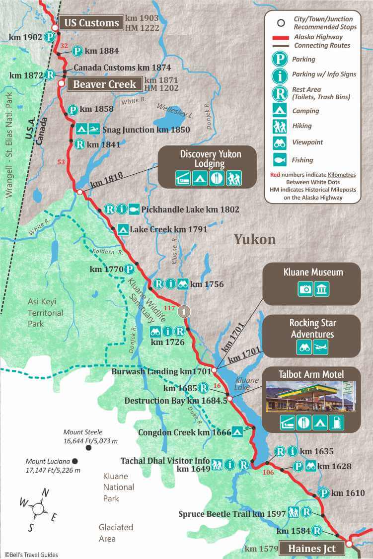
Tachal Dhal Visitor Information Center. Rest area. Viewing platforms with telescopes for viewing sheep. Interpretive programs. Open mid-May to mid-September.
Slim’s River West trailhead adjacent to information center.
1662.5
Rest Area.
1666.1
Congdon Creek Campground, 81 camp sites, tables, toilets, kitchen shelter. Fee area.
1684.4
Destruction Bay. Small highway community.
1684.5
Talbot Arm Motel. For over 45 years Talbot Arm Motel has served the traveling public. Open year-round it has 32 clean and comfortable motel units Satellite TV and Wi-fi, a full service dining room, cocktail lounge, groceries, liquor off sales and ice. Fas Gas, diesel, oil products and propane. Water, hot showers, Laundromat and clean rest rooms. Overnight RV parking and winter plug-ins are available. 867-841-4461
1700.6
Kluane Energy Cafe
1700.8
Kluane Museum
1700.8
Rocking Star Adventures
1702.8
Burwash Airport.
1728.9
Quill Creek. Site of Hudson’s Bay Company nickel mine, the Wellgreen, which closed in 1973.
1755.5
Rest area, toilets. Interpretive display. Mount Walsh is visible from here. Canada’s highest peak, Mount Logan (5957 m/19,545 feet), and Mount Kennedy, named for the late U.S. President, are obscured by intervening mountains.
1791.1
Lake Creek Campground, toilets, tables and kitchen shelters. Fee area.
1802.1
Pickhandle Lake Recreational Site
1818
Discovery Yukon Lodging has cabins, full service RV sites and tent camping. This wilderness oasis offers a wide range of amenities for guests. Free Wi-fi hotspot at the main lodge, hot showers, beer & wine sales, an amazing bistro and they are pet-friendly.
1849.6
Snag Junction Campground, 15 sites, toilets, tables, picnic shelter, fire pits. Fee area.
1870.6
Beaver Creek Population 100
1202 Motor Inn & RV Park
1870.8
Day use picnic area.
1873.8
Canada Customs and Immigration, open 24 hours a day year round. All traffic entering Canada must stop.
1902.5
Canada/ USA International Border. Rest Area; information sign with facts on International border.
1902.5
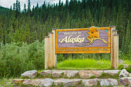
(HM 1222) US Customs and Immigration. All traffic entering Alaska must stop. Open 24 hrs. Time Zone Change. If you are traveling to Alaska it is one hour earlier, The Yukon is on Pacific Time Zone. It is the law in Alaska to travel with your headlights on at all times.
Due to Alaska Highway reconstruction, There is a 40mile/64 Kilometre difference between the Yukon Log Numbers and the Alaska Road Log Numbers when you cross the border.
The Yukon and British Columbia have placed new kilometre posts while Alaska still uses the original milepost markers. The Alaska Highway road log below uses the actual Alaska mileposts.
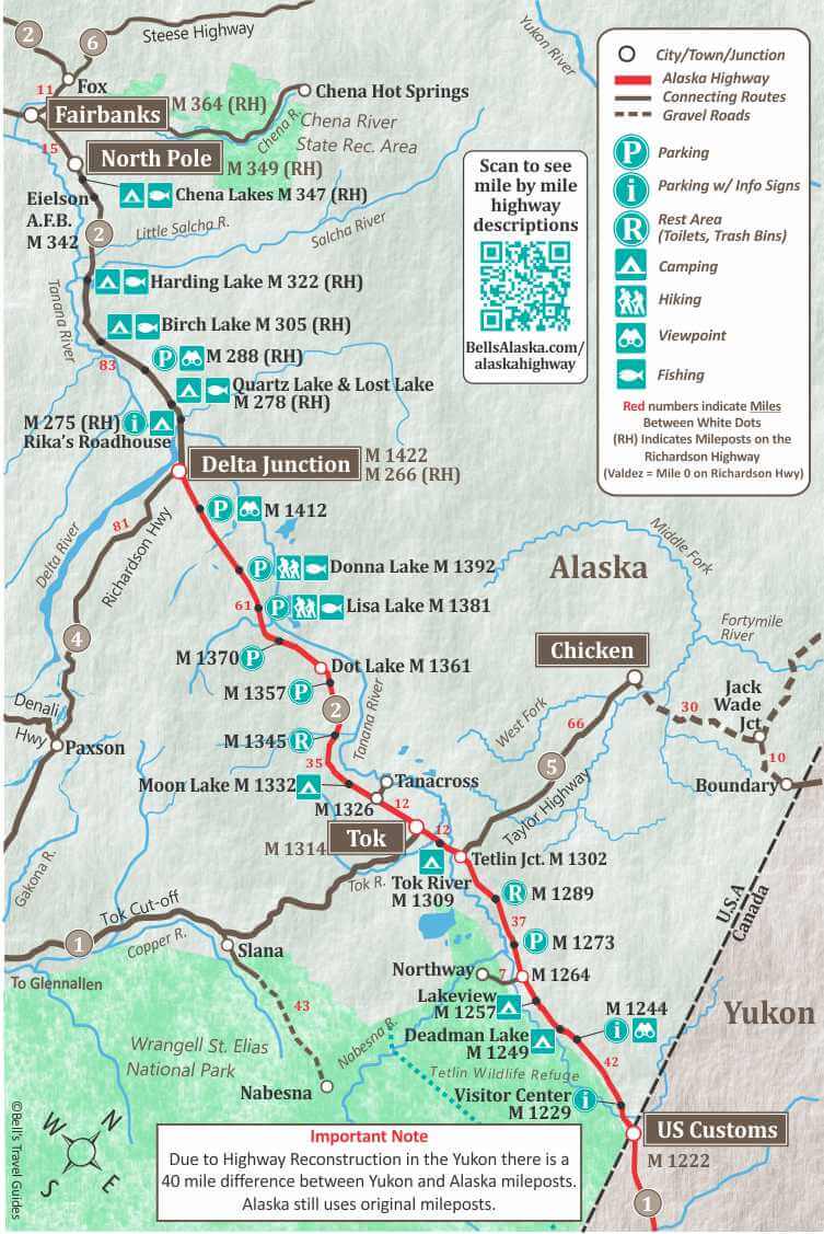
1223
East boundary of Tetlin National Wildlife Refuge.
1224.8
Interpretive sign, parking, the Arctic Loon can often be seen in these marshes.
1225.5
Border City Trading Post.
1228
Parking with information sign on “Corridors for Passage”.
1229
Tetlin National Wildlife is a dynamic landscape made up of forests, wetlands, tundra, lakes, mountains and glacial rivers bounded by the snowy peaks of the Alaska Range. This upper Tanana River valley has been called the “Tetlin Passage,” because it serves as a major migratory route for birds traveling to and from Canada, the lower 48 and both Central and South America.
Tetlin Refuge also supports a variety of large mammals. Dall sheep dot the higher slopes while moose feed upon the tender new growth that springs up in the wake of frequent lightning caused fires. Wolves, grizzly and black bears and members of three different caribou herds range over the refuge.
As one of the only two road-connected Alaskan refuges, Tetlin has the unique opportunity of reaching nearly all the visitors who travel to the state via the Alaska Highway.
There is a visitor reception center with interesting display at mile 1229.
1243.6
Scenic view, Information sign on “The Changing Landscape”.
1249.5
Deadman Lake Public Campground. mile 1249 has 15 campsites (4 sites are suitable for large RV’s) firepits, toilets, picnic tables, boat ramp, no drinking water. There is a self-guided 1⁄4 mile Taiga Trail walk at the campground. Canoes & lifejackets are available to use on Deadman Lake. During the summer, Ranger lead wildlife programs are conducted Monday through Friday at 7pm.
1252.2
Parking with Information sign on the “Solar Basin”.
1256
Lakeview Public Campground. 8 camp sites, boating, fishing.
1264
Northway Junction, visitor facilities. 7 mile/11 km side road to Northway-groceries, motel, gas, camping. The Community is made up of approximately 400 people, mainly Athabascans. Northway was named after the late chief Walter Northway, who passed away in 1993 at the age of 117.
1269
Scenic view of Tanana River, parking with Information sign on “Highways of Water”. 100 yards upstream the Chisana and Nabesna Rivers join to form the Tanana River.
1289.4
Rest Area with bathrooms. Scenic view, turn around limited for RV’s towing vehicles. Interpretive sign.
1301.7
Tetlin Junction.
(Taylor Highway to to Chicken and Eagle. The Taylor Highway is part of the Top of The World Highway, which connects to Dawson City, Yukon. Chicken is 66 miles from the Junction. Eagle 161 is miles/259 km. Dawson City is 174 miles/280 km. The Taylor Highway is the north end of the 500 mile/800 km “loop highway” which takes you through Dawson City, Yukon. The south end of the loop connects with the Alaska Highway at mile 925/1488 km near Whitehorse. See The Top of the World Highway.
1309.3
Tok River State Recreation Site. 1309 Alaska Highway has 27 campsites, picnic areas, hiking trails and drinking water. Suitable for large RVs.
1314
Tok Alaska. Tok is often referred to as the “Gateway to Alaska,” because it is the first major community in Alaska you come to when heading north. The Alaska Highway also intersects here with the Glenn Highway
Tok Mainstreet Visitor Centre
There is statewide information for your entire trip planning needs and is also home to a museum & gift shop. www.tokalaskainfo.com
1314.8
Northern Energy
1332
Moon Lake State Recreation Site. 17 camp sites, tables, water, toilets, boat launch, good swimming, beach. A nice spot but camp sites are small.
1414.8
Clearwater State Recreation Site, 8.5 miles northeast on Jack Warren loop road, travels through the extensive farmland of the Delta Junction area. It rejoins the Richardson Highway at mile 268, just north of Delta Junction. 15 camp sites, water, toilets, boat launch. Grayling fishing in Delta-Clearwater River. Fee area.
1422
Delta Junction Alaska, Delta Junction marks the true end of the Alaska Highway. This is the junction of the Alaska and Richardson Highways. You will be travelling on the Richardson Highway to Fairbanks, if you are continuing North.
Delta Junction Visitor Center
Stop in for comprehensive information and souvenirs from the gift shop. Certificates for completing the Alaska Highway are available. www.deltachamber.org/visitorcenter.html
The Road Log Continues below from Delta Junction to Fairbanks on the Richardson Highway.
You can see the full Richardson Highway Road Log here.
266.3
(Richardson Highway Mileage) Delta Junction Post Office.
267
Delta State Recreation Site. 25 camp sites, water, tables, toilets, picnic shelters, Fee area.
268.3
Clearwater State Recreation Site on Jack Warren Road, 11 miles km on good road. Campground has 17 camp sites, picnic area, tables, toilets, water and boat launch. You can continue on this road 8.5 miles to the Alaska Highway mile 1415/km 2277.
275
Tanana Trading Post and Tesoro Gas station to South side of highway. Big Delta State Historical Park and turn off to Rika’s Roadhouse on North side of highway.
Rika’s Roadhouse at Big Delta State Historical Park. This historic roadhouse was opened in 1909 and ran into the 1950s. Stop by to learn the fascinating history.
275.4
Big Delta Bridge and Trans-Alaska Pipeline Bridge elevated 40 ft. above the Tanana River, this 1200-ft. bridge is the second longest on the route. (The longest crosses the Yukon River north of Fairbanks). Good view of the Alaska Range to the south. Large parking area at east end of bridge.
277.8
Quartz Lake State Recreation Area, access via 3-mile side road. 87 camp sites, Facilities include two boat launches, a handicap accessible fishing dock, picnic sites, a picnic shelter, swimming area, beach volleyball court, water, and toilets. Stocked with rainbow, trout and cohoe. Boat recommended. Fee area. There are 12 camp sites at Lost Lake. Facilities include picnic area, water and toilets. Lost Lake is not stocked but its small picnic area is a favorite spot for those who want to enjoy the area’s scenery and wildlife.
286.7
Shaw Creek. Large parking area and boat launch good early spring and fall grayling fishing. Picnic table. View of Mt. Deborah (12,339 ft.) to the west, Mt. Hayes (13,832 ft.) to the southwest and Mt. Hess (11,940 ft.) between the two former peaks. All are a part of the Alaska Range which spans southcentral Alaska in a sweeping 600-mile arc.
305.2
Birch Lake State Recreation Site is reached by turning north onto the gravel road for 1/4 mile. 17 camp sites, picnic area, toilets, swimming. Boat launch, excellent rainbow and trout fishing (boat recommended).
306
Rest area beside Birch Lake. Toilets.
321.5
Harding Lake State Recreation Area is a highly developed recreation area 45 miles southeast of Fairbanks (1.5-mile side road to campground on north side of Harding Lake) off the Richardson Highway. Harding Lake, is one of the few natural lakes near Fairbanks that can be reached by road, it is a favorite spot to swim, boat and fish. There are 90 camp sites for vehicles, a walk-in group camping area, toilets, water and dump station. There is also a large picnic and beach area with dressing rooms, a baseball field, volleyball court, horseshoe pits and campfire area. Resident ranger. Pike and lake trout. Harding Lake was a brief stopover for Will Rogers & Wiley Post on their ill-fated flight to Barrow, Alaska. Be sure to bring along your mosquito repellent!
323.3
Salcha River State Recreation Site. 130 sites, boat launch, picnic area, toilets and water. Fishing for grayling and king salmon is good in the Salcha River. Fee area.
325.5
Community of Salcha.
342
Eielson Air Force Base Main Gate.
Built in 1943. Named for Carl Ben Eielson, famous Alaskan bush pilot.
346.7
Laurance Road. Chena Lakes Recreation Area.
349.5
Badger Road is a 12 mile loop which rejoins the Richardson Highway at mile 357.
349.4
North Pole Alaska. Home to the famous Santa Claus House.
357
Badger Road is a 12 mile loop which rejoins the Richardson Highway at mile 349.5.
360.6
bypass via the Mitchell Expressway to the Parks Highway to Denali National Park.
364
Alaska’s second largest city and has a population of 32,000 and a Borough population of almost 100,000, including the nearby military bases. Fairbanks is the hub for Alaska’s Interior and Arctic with first-class accommodations and restaurants, museums, world-renowned concerts and performances, upscale galleries and specialty stores, historic sites, Alaska Native culture, and access to the Alaskan wilderness.
The Morris Thompson Cultural and Visitors Center
The 9,000 square-feet of interpretive space features exhibits on the land, the seasons and the peoples of Interior Alaska and the Arctic. www.explorefairbanks.com
Accommodations & Camping
Things to Do in Fairbanks