Experience an awe-inspiring journey through two countries with a shared Gold Rush history. The Golden Circle Route, is an easy and highly recommended drive that explores the incredible scenery, unique towns, the rich history of the First Nations and the most famous Gold Rush of them all, the Klondike Gold Rush of 1898.
367 miles/591 km of stunning highways plus an unforgettable journey on the Alaska Marine Highway Ferry that links Skagway, Haines and Juneau. This majestic journey crosses amazing mountain landscapes, with a fascinating human history that is often brought to life by the bard of the North, Robert Service, in his many books and poems.
Use our Bell’s Travel Planner to discover accommodations and activities that match your interests on the Golden Circle Route through Alaska and Yukon.
Open the planner –> Select any Driving option (Rental Car, Rental Motorhome or Your own Vehicle) –> Select “Routes to Alaska” and then select “The Golden Circle”-
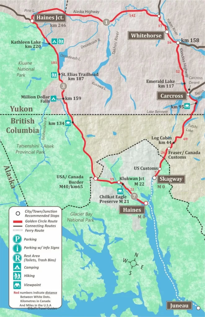
Golden Circle Map
This map of the Golden Circle Route shows the 174 km/108 mile drive from Whitehorse to Skagway, the Alaska Marine Highway Ferry ride to Haines and Juneau, and the 246 km/153 mile drive from Haines, Alaska to Haines Junction, Yukon. This circle route is completed with a 154 km/96 mile drive on the Alaska Highway, back to Whitehorse.
Whitehorse to Skagway on the South Klondike Highway
Driving Time: 2 hours
Distance: 174 km/108 miles.
Many visitors will start their Golden Circle journey in Whitehorse, the capital of the Yukon and a vibrant city that serves as a crucial hub for outdoor adventurers and history enthusiasts.
A must see, Whitehorse landmark, is the SS Klondike, a sternwheeler boat that transported supplies and people through the Yukon during the Gold Rush. Today it stands as a National Historic Site on the banks of the Yukon River.
Being on the historic Alaska Highway, Whitehorse has a unique transportation legacy. The city is home to the Yukon Transportation Museum, which showcases the history of transportation in the Yukon, from dog sleds to airplanes.
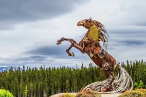
Explore First Nations’ art and heritage at the Kwanlin Dün Cultural Centre or visit the MacBride Museum of Yukon History to delve deep into the region’s gold mining past, wildlife, and First Nations culture. If you’re looking to see a unique and interesting sculpture, visit the “Horse of Whitehorse” found near the top of Two Mile Hill in Whitehorse. This interesting piece of artwork is made entirely of donated scrap metal from across the Yukon.
Miles Canyon is an ancient and beautiful landscape just a few minutes drive from downtown. This natural wonder, with the emerald green Yukon River and steep cliffs, offers a panorama of Yukon’s untamed beauty, with hiking trails and ample bird-watching opportunities.
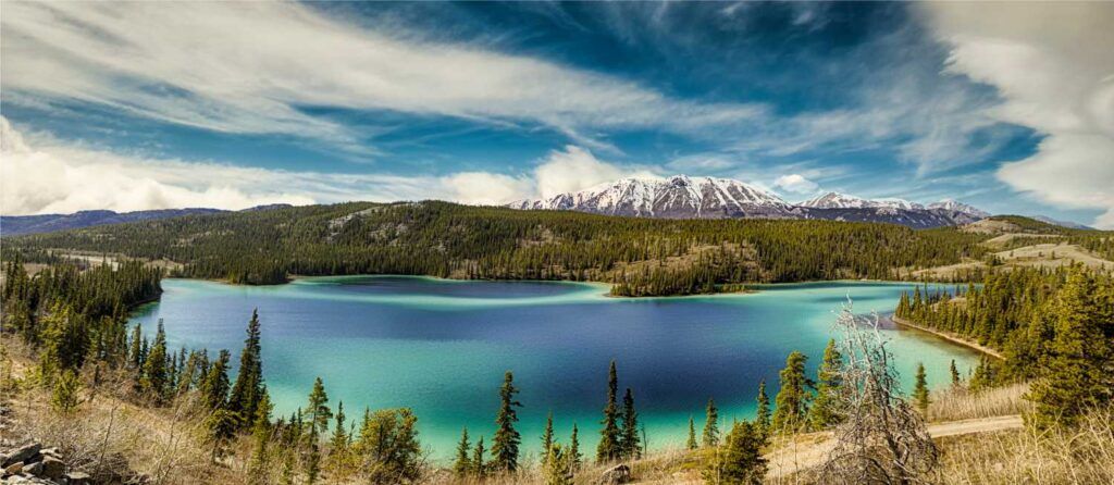
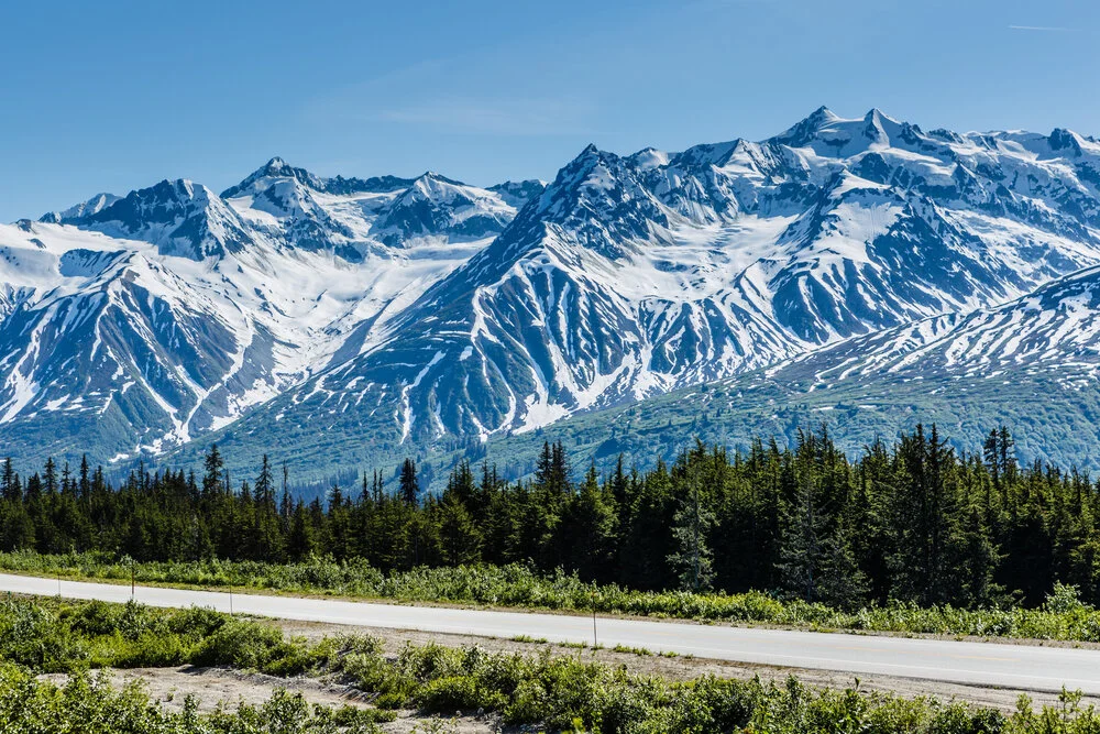
When done exploring Whitehorse, it’s time to begin the Golden Circle Route journey. Start by going South on the Alaska Highway to the South Klondike Highway. Head towards the village of Carcross. But before reaching Carcross, be sure to make your first stop at Emerald Lake, a stunning colourful lake at Km 117, only 11 km north of Carcross.
Emerald Lake
This is one of the most photographed lakes in the Yukon due to its vibrant turquoise hues. These colors result from sunlight reflecting off a layer of calcium carbonate clay on the lake bottom. Emerald Lake is easily viewed from a pullout on the side of the highway.
Carcross
Carcross, which is short for ‘Caribou Crossing’, is a charming and historic village nestled on the shores of Bennett Lake, only 70 km south of Whitehorse. Carcross is surrounded by majestic mountains, pristine lakes, and the Carcross Desert, known as the world’s smallest desert.
It is home to the Carcross & Tagish First Nations and it served as a key stop during the Klondike Gold Rush. explore the lovingly restored historic buildings and Carcross Commons, an area filled with local artisans’ shops and a variety of eateries. The Matthew Watson General Store has been operating since the gold rush and is a fun step back in time. Shop their local gifts or buy snacks like home-made fudge or ice cream.
Carcross isn’t just defined by its past, though. It boasts some of the Yukon’s best mountain biking trails, known as the Montana Mountain Trails, making it a popular destination for thrill-seekers from all over.
South of Carcross the Klondike Highway passes Windy Arm and Tutshi Lake and the outpost of Fraser, where the Canadian Border station is located. This is also one of the stops on the White Pass and Yukon train. The highway crosses the border into Alaska, just 11 km/ 7 miles before reaching Skagway.
White Pass & Yukon Route
Prospectors were spared the grueling trek over the Chilkoot Trail once the White Pass Railroad was built from Skagway to Carcross. The White Pass & Yukon Route Railroad is still operating, now as the most popular visitor attraction in Alaska. The spectacular, narrow gauge railway, route clings to the mountainside as it snakes its way over the famous White Pass.
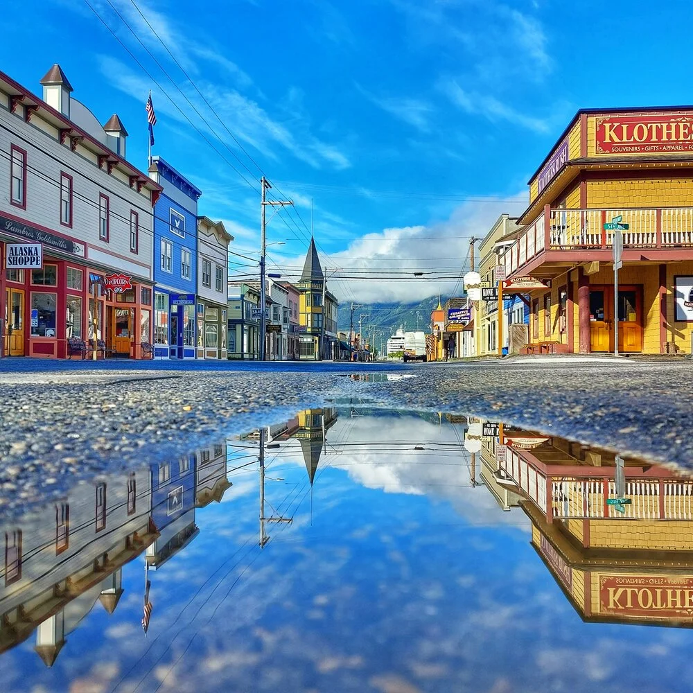
Skagway Alaska
Nestled at the northernmost point of the Inside Passage, Skagway (Shgag̱wéi), is locate on traditional lands of the Lḵoot Kwáan (Chilkoot Tlingit people). Skagway served as the gateway to the gold fields of the Klondike Gold Rush, in 1898.
The town’s historic district has preserved much of its early charm, with wooden boardwalks, beautifully refurbished buildings, and the quaint yet bustling Broadway Street filled with shops, eateries, saloons, and art galleries. The Klondike Gold Rush National Historical Park in Skagway offers fascinating insights into this past era, while the White Pass & Yukon Route Railroad offers scenic tours along the old Gold Rush train route, with breathtaking views of mountains, glaciers and waterfalls.
Located within the boundaries of the Tongass National Forest, the largest national forest in the U.S., Skagway is surrounded by lush rainforest, snow-capped mountains and an array of wildlife such as seals, mountain goats, eagles, and even black bears and brown bears.
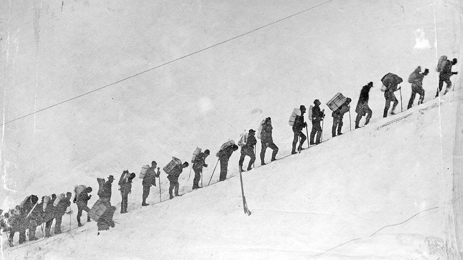
The Chilkoot Trail
The world famous Chilkoot Trail begins just outside of Skagway, in Dyea. The trial, once traversed by thousands of gold rush prospectors, follows a spectacular route through tree-lined paths, icy rivers, steep ascents, and stark landscapes before culminating at Bennett Lake, near Carcross, in the Yukon Territory.
The Chilkoot Trail was the route most prospectors heading to Dawson City used during the Klondike Gold Rush. The north end of the trail, in the Yukon, is only accessible via the White Pass Train to Bennett City (an abandoned ghost town), or a 7 mile hike from Log Cabin (at Km 44 of the South Klondike Highway).For more information go to:
https://parks.canada.ca/lhn-nhs/yt/chilkoot/activ/randonnee-usa-cdn-hiking
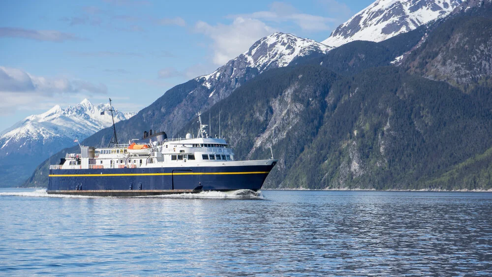
Skagway To Juneau on the Alaska Marine Highway
Skagway to Haines: 1 Hour Ferry
Haines to Juneau: 4.5 Hour Ferry
The next step in the Golden Circle itinerary will require embarking on one of the most beautiful ferry rides in the world. The Alaska Marine Highway connects to all of Alaska’s major coastal towns, which are collectively designated a National Scenic Byway. However, it could be argued that the Lynn Canal from Skagway to Juneau is the most spectacular section of the Inside Passage, with rugged coastal mountains in every direction.
To continue on the Golden Circle Route, take the 1-hour ferry ride to Haines before heading north on the Haines Highway, back to the Yukon.
We recommend planning your trip to stay aboard and continue to Juneau, the Capital of Alaska, one of Alaska’s most picturesque and historic cities.
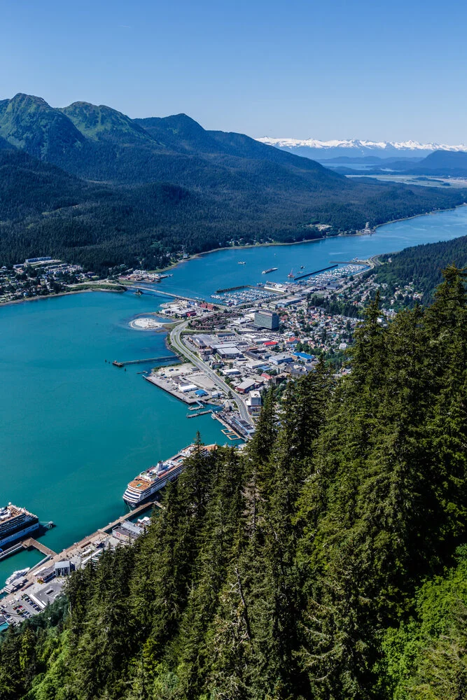
Juneau, Alaska’s Capital
Juneau, the capital city of Alaska, is a remarkable fusion of stunning natural beauty and rich cultural history. It sits, nestled at the base of towering mountains, situated at the southern end of Lynn Canal on the scenic Gastineau Channel.
One of Juneau’s most incredible attractions is the Mendenhall Glacier. Part of the Juneau Icefield, this massive 12-mile-long glacier is a spectacle with blue-tinged icebergs dotting Mendenhall Lake after calving off the face of the glacier. Situated in the 17-million acre Tongass National Forest, the largest temperate national forest in the world, there are over 250 miles of hiking trails, wildlife viewing opportunities, and exploration for outdoor enthusiasts.
The city revolves around Government, indigenous culture, tourism, mining, and fishing. Attractions like the Alaska State Museum and the Goldbelt Tram showcase the rich heritage of the state, from Native American history to the gold rush era.
To continue your Golden Circle Route, take the Alaska Marine Highway back to Haines and explore this peaceful inlet town. Haines not only provides a glimpse into the culture and traditions of Alaska’s indigenous people, but also offers travelers the chance to spot a rich variety of wildlife from bears to bald eagles in this coastal rainforest.
Haines to Haines Junction on the Scenic Haines Highway
Driving Time: 3 hours
Distance: 246 km/153 miles
Haines
Located on the shores of the Lynn Canal, America’s longest and deepest fjord, lies the charming town of Haines – a hidden gem in Southeast Alaska. Hailed as the “Adventure Capital of Alaska,” Haines is the perfect location for thrill-seekers and nature lovers. It attracts visitors looking to enjoy hiking, fishing, rafting, bird & bear-watching, and skiing. It’s also located near the famed Chilkat Bald Eagle Preserve, where the largest concentration of bald eagles in the world congregates each October.
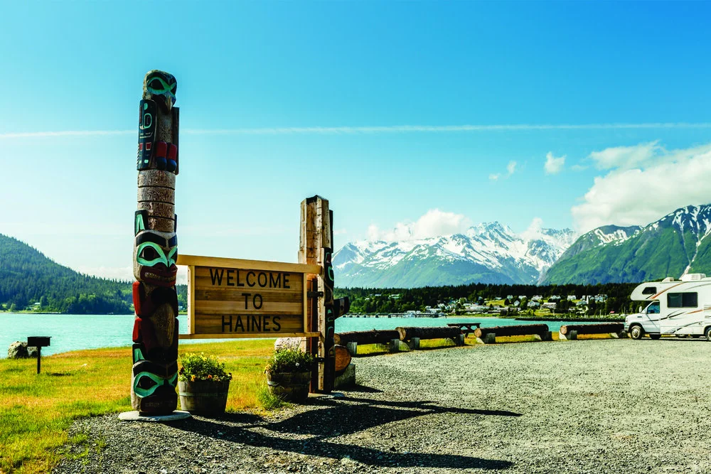
Originally Inhabited by the Tlingit people, this coastal town’s history is kept alive at the wonderful Sheldon Museum. Visitors can also visit the eclectic, one of a kind, Hammer Museum, or the American Bald Eagle Center to explore more of Haines’ cultural gems.
This picturesque fishing village is known as a hub for artists, which is reflected in the many art galleries found around town and its annual summer arts festival. The Southeast Alaska State Fair, and the Bald Eagle Festival are two other major attractions, drawing locals and visitors to this small coastal town.
Fort William H. Seward, was Alaska’s first permanently established military post, and adds a unique charm to Haines, recalling its past while offering a range of modern amenities including an award winning distillery, shops, restaurants, accommodations and art studios.
Haines Highway
The next leg of your Golden Circle leads from Haines along the Haines Highway, a National Scenic Byway, towards Haines Junction.
The only village on the Haines Highway is the ancient Alaska Native village of Klukwan, 22 miles North of Haines. Situated in the rich natural environment of the Chilkat Valley, the Chilkat Tlingits have created the Jilkaat Kwaan Cultural Center to share their culture and history.
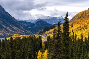
The Haines Road skirts the edge of the largest UNESCO World Heritage site in the world. This protected natural wonder includes three national parks and one provincial park: Glacier Bay National Park, Tatsenshini – Alsek Provincial Park, Kluane National Park, and the adjoining Wrangell-St. Elias National Park. The snow covered and glaciated landscape of these national treasures form the largest non-polar icefield in the world.
Once the Haines Highway crosses the Canadian Border it runs alongside Tatsenshini – Alsek Provincial Park in British Columbia and Kluane National Park in the Yukon. Both parks are wilderness parks, mostly without services. There are several Provincial/Territorial campgrounds along the way. Kathleen Lake, 25 km south of Haines Junction, is in Kluane National Park and offers camping facilities for visitors looking to get a taste of this incredible area. If you plan to hike in the Park, be bear aware. Grizzly bears are often seen in the area and hikers should always carry bear spray.
The Chilkat Pass on the Haines Highway
This high-mountain passage stands at an elevation of 3,510 feet (1,070 m). Serving as a geographical boundary between Alaska and British Columbia. Drenched in history, the Chilkat Pass was previously a trade route for the indigenous Tlingit people, who traded with the First Nation Tribes of the interior. During the Klondike Gold Rush, it was used by gold seekers looking for shorter and less challenging passage to the goldfields of the Yukon.
This picturesque route is also home to a wide array of wildlife, including grizzly bears, wolves, and a variety of bird species.
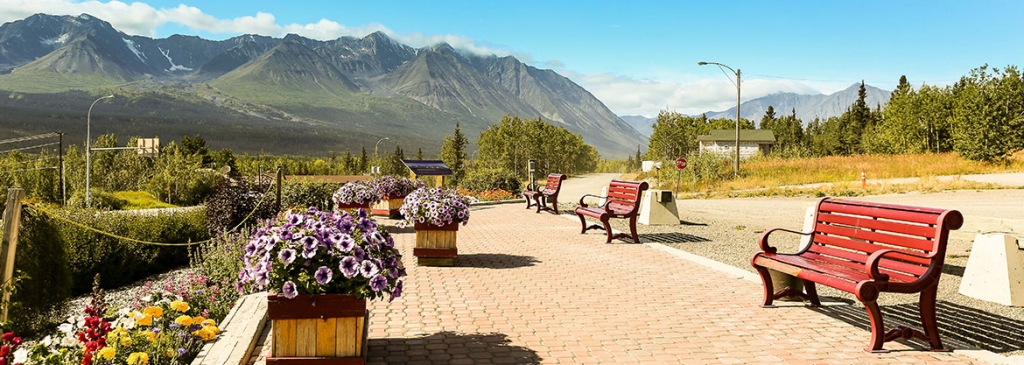
Haines Junction
Haines Junction, in the Yukon is the smallest town on the Golden Circle Route, but that doesn’t mean it lacks in stunning scenery or opportunities to explore.
Nestled amidst breathtaking mountains and clear, glacial rivers, Haines Junction serves as a gateway to a variety of outdoor adventures. Kluane National Park, a UNESCO World Heritage Site, is home to Canada’s highest peak – Mount Logan, magnificent glaciers, the largest icefield outside the polar caps, and abundant wildlife making it a haven for hiking, mountaineering, rafting, and wildlife viewing.
The village itself was originally established as a construction camp during the building of the Alaska Highway, and the Haines Junction visitor center offers detailed exhibits on this history. It also provides valuable information for tourists on the local flora, fauna, and options to explore the grandeur of Kluane National Park and Reserve.
The Champagne and Aishihik First Nations, the original inhabitants of this area, have had a significant influence on the culture and heritage of Haines Junction. The Da Kų Cultural Centre in the village is a wonderful place to learn about the traditions, history, and art of these indigenous communities.
Returning to Whitehorse on the Alaska Highway
Driving Time: 1.5 hours
Distance: 154 km/96 miles
The final leg of the Golden Circle Route has travelers return to the Alaska Highway; retracing part of the historic road built during World War II. Haines Junction is only 154 km from Whitehorse, and an easy 1.5 to 2 hour drive. Back in Whitehorse, the unforgettable Golden Circle Route is now complete.
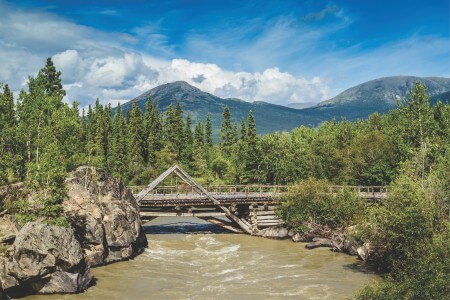
Take time to stop by Canyon Creek bridge at km 1547.5 to see the replica bridge built in the original style used on the Alaska Highway during its construction.
Alternatively, for visitors who are heading north to Alaska, you can leave the return trip to Whitehorse for later and head directly north on the Alaska Highway from Haines Junction. The scenery remains awe inspiring as the Alaska Highway continues to parallel Kluane National Park and skirts the shores of the beautiful Kluane Lake.
This diverse and uniquely Alaskan journey, known as the Golden Circle Route, guarantees every traveler a blend of cultural insight, historical exploration, and unforgettable scenic views.