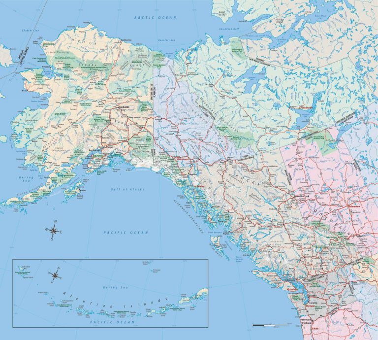
Below are maps of all the major highways in Alaska and leading to Alaska. These highways include The Parks Highway, Seward Highway, Alaska Highway, Klondike Highway, Glenn Highway, Richardson Highway and Sterling Highway. Below each Highway are links to the major towns and cities on each Highway.
The Alaska Highway is 1422 miles long and the longest highway, by a long ways, that we detail on our website. Built during World War II, it has been continually improved over 80 years. What began as not much more than a goat path is now an excellent, paved, two lane highway with plenty of space for all types of vehicles. Drivers of large RV’s do not need to fear driving the Alaska Highway.
The northern section between Haines Junction and Tok is typically the roughest part of the road, with plenty of bumps and frost heaves. We suggest taking your time through this section and enjoying the scenery at one of the many campgrounds along the way.
The Parks Highway is the named for George Parks, and not because it is the highway that connects to Denali State Park and Denali National Park. Denali National Park has many of Alaska’s most luxurious lodges.
The Parks Highway is also the main route between Anchorage and Fairbanks. It is 358 miles long (576 km) and is open year round. It is a wide well-maintained road with speed limits up to 65 mph. At mile 99 you can take a 14 mile side road to the frontier town of Talkeetna.
Talkeetna has great views of Denali and is the where most of the flightseeing trips of Denali depart take off. The Parks Highway is also the western end of the Denali Highway which connects to Paxson on the Richardson Highway.
The Seward Highway is one of the shortest highways in the State, but what it lacks in distance it more than makes up for in spectacular scenery. The highway connects Anchorage to Seward, in the Kenai Peninsula, passing snow capped mountains next to the stunning Turnagain Arm inlet. The highway connects visitors to Whittier, Portage Recreation Area and the small gold rush town of Hope. If you’re looking to camp in Seward, check out our list of RV parks near Seward.
The Richardson Highway starts in Valdez, Alaska and connects to Fairbanks. It is the first highway in Alaska. Originally built during the Gold Rush of the early 1900s, it was a pack trail for prospectors. It was improved and made suitable for vehicles in the 1920’s and paved in the 1950’s. Valdez is one of the premier visitor destinations in Alaska, for both Alaskans and our of state visitors. It has beautiful scenery, access to glaciers and Prince William Sound as well as spectacular fishing.