The Yellowhead Highway officially starts in Massett, on Haida Gwaii (Formerly known as Queen Charlotte Islands) and includes the ferry crossing from Skidegate to Prince Rupert. From Prince Rupert, the Yellowhead route crosses the western provinces of BC, Alberta and Saskatchewan before officially ending in Winnipeg, Manitoba. The entire length of the Highway is numbered Highway 16 and is part of the Trans Canada Highway System (Not to be confused with the southern Trans Canada Highway #1).
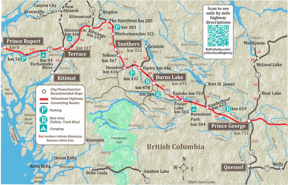
The section of the Yellowhead Highway covered here is 733 km/455 miles and takes you from Prince George in the center of British Columbia to Prince Rupert on BC’s Pacific coast. Prince Rupert is the terminus for two coastal ferry Systems –The Alaska Marine Highway System, and the British Columbia Ferry System.
The entire Yellowhead route is paved, and Yellowhead Pass, in Jasper National Park and between the BC/Alberta border is the lowest elevation mountain pass through the Canadian Rockies. It is a river route, paralleling the Nechako, Endako, Bulkley, and Skeena Rivers.
East of Prince George, the Highway passes through Jasper National Park and the nearby small town of Tête Jaune Cache, which translates to Yellow Head Cache. The Yellow head name comes from the nick name for Pierre Bostonais, a Metis Iroquois fur trader and explorer with yellow streaks in his hair, who guided the Hudson Bay company westward from Edmonton, through the Rocky Mountains in the early 1800s.
The Yellowhead Highway and the Cassiar Highway is an alternate route to the Yukon and Alaska. It is approximately 100 miles shorter to Fairbanks from Prince George but typically slower due to road conditions on the Cassiar Highway. The more traditional route to Alaska is on the Alaska Highway, via Dawson Creek.


Yellowhead Highway Highlights
721
Prince George at the Junction Highway 16 and Highway 97. Prince George offers all the amenities you would expect of the largest BC city on the Yellowhead Highway. While visiting Prince George, you will find top notch theatre, accommodations, restaurants, and unique gift stores.
Prince George Visitor Center
Located downtown in the Via Rail Building at 1300 First Ave. www.tourismpg.com
617
Junction to Fort St. James. Fort St. James is designated as a National Historic Site because of its importance in BC’s history. Established 1806 by Simon Fraser as a fur trading post for the Northwest Co. Stop in to see the largest collection of original wooden buildings representing the fur trade in Canada.
587
Fort Fraser, with a population of about 1000 people, is located on the Nechako River at the eastern end of Fraser Lake about 1 1/2 hours west of Prince George, BC.
On April 7, 1914, the “Last Spike” of the Grand Trunk Pacific Railroad was driven near Fort Fraser. This was Canada’s second Trans Continental Railway and linked the Prairies with the West Coast and Prince Rupert.
583.5
Beaumont Provincial Park on Fraser Lake. Campground has 49 campsites, picnic tables, water, rest rooms, playground, dump station. Good swimming beach, boat launching. Fishing for Rainbow and char. One of the buildings of the original Fort Fraser sits at Beaumont Provincial Park. This fort was built during the fur trade in 1806 by the Northwest Company and named after Simon Fraser.
567
Fraser Lake. Originally built for Endako Mines Ltd. in 1964 to aid the development of what was then Canada’s largest molybdenum mine. In 1982, when metal prices fell, the mine was closed. The main industries now are lumbering and tourism.
495
Burns Lake. There is a Travel Info Center and Museum on the highway. Junction of Highway 35 leads south 16 km to Tchesinkut Lake, 24km to Francois Lake and ferry crossing to Southside area.
445.7
Topley is located 50 km west of Burns Lake and is at the junction with Highway #118. It is 49 km north to Granisle and scenic Babine Lake, the longest (110 miles) natural lake in BC.
Babine Lake Provincial Park has 16 camp sites, water, toilets and boat launch. Babine Lake is 45 km north of Burns Lake.
Red Bluff Provincial Park has 27 camp sites, day-use area, water, toilets, boat launch, beach and biking trails. The BC Fisheries Fulton River Sockeye Project here is one of the largest in the world. Visitors are welcome. Excellent rainbow trout, cutthroat trout, and ling cod fishing.
Topley Landing also has resort with campground and marina.
416.3
Houston. The population of Houston is approximately 3,200. Travel Info Center at km 416.3
367.5
Tyhee Lake Provincial Park, 59 camp sites, day-use area, showers, toilets. Beach, interpretive trail and wildlife viewing platform. Boat launch and sani-dump.
367
Telkwa. Population 1350. All visitor facilities are available in this quiet northern town. The museum, located in the schoolhouse in the center of town is packed with Telkwa’s history.
355.5
Driftwood Canyon Provincial Park. day-use area, toilets, self-guiding interpretive trail and viewing platform.
Driftwood Canyon is recognized as one of the world’s most significant fossil beds.
352
Smithers. Developed as a divisional point on the Grand Trunk Pacific Railway in 1913. Smithers was named for the head of the Grand Trunk Pacific Railway, Sir Alfred Smithers. The train station was built in 1918 and in 1921 it became the first incorporated village in BC.
321
Moricetown is a First Nations community of the Wet’suwet’en People who have thrived in northern BC for centuries. The high canyon on the Bulkley River provides great views of the canyons and also great fishing. You may be able to watch a local fisherman use either fly rods or gaff poles to fish in the canyon.
287.5
Ross Lake Provincial Park, day-use area. Toilets, boat launch, hiking trails. Fishing, swimming and canoeing. 4 km side road.
285
The Hazeltons, Travel Info Center. Population is approximately 1,358.
274.5
Seeley Lake Provincial Park. 20 campsites, picnic sites, water, swimming, fishing. Fee area.
258
Parking. There is a Historical Plaque on Skeena Crossing.
First Nations Kitsequecla Village. Many Totems are scattered throughout the village still in their original locations.
241
Kitwanga Junction. Junction of Cassiar Highway 37 (north to Stewart, BC; Hyder, Alaska; and Watson Lake, Yukon).
166.3
Kleanza Creek Provincial Park. 32 camp sites, group site, picnic tables, pump for drinking water. Access via 1 km paved side road. Features canyon with cascading waterfalls, hiking trail to top of canyon with view point and intermediate kayaking.
151
Junction with Highway 37 to Kitimat (59km/36 miles) and Airport (5km/3 miles).
Lakelse Lake Provincial Park, 19 km/12 miles, has 156 campsites, log house picnic shelters, drinking water, flush toilets, showers, boat ramp, swimming, fishing, dump station.
150
Skeena River Bridge.
149.8
Ferry Island Campground.
147
Terrace. Travel Info Center on Keith Avenue. Population 12,000.
94
Exchamsiks River Provincial Park; 20 camp sites, picnic tables, water, toilets, walking paths, all night security – gate controlled. Salmon and trout fishing.
24.5
Prudhomme Lake Provincial Park; 24 camp sites, water, toilets and fishing. Nature trail through the rainforest.
23
Diana Lake Provincial Park Day-use area reached by 2.5 km/1.6 mile gravel side road. toilets, hiking trail, and beach.
15.3
Junction to Port Edward (10 km/6 miles), North Pacific Cannery Village Museum is now a National Historic Site and is open to the public.
6.5
Prince Rupert. Downtown. Prince Rupert is the terminus for Ferry traffic to Southeast Alaska, Haida Gwaii and Vancouver Island. It is one of the deepest, natural ice-free harbours in the world.
0
Prince Rupert Ferry Terminal.
Yellowhead Highway Map