The Richardson Highway is Alaska’s oldest road and one of its most geographically dramatic โ 364 miles connecting the saltwater shores of Valdez to the Interior at Fairbanks. The drive takes you through five distinct ecosystems in a single day: Prince William Sound, the narrow walls of Keystone Canyon, alpine tundra at Thompson Pass (at 2,805 ft, it is the holder of Alaska’s single-season snowfall record at over 80 feet), the wide Copper River Valley framed by WrangellโSt. Elias โ the largest national park in the US โ and finally the open flatlands of the Interior. The Trans-Alaska Pipeline parallels much of the route, an elevated silver tube engineered to flex through earthquake-prone terrain. Dall sheep haunt the slopes near the pass; grizzlies and moose are common in the river corridors of the highwayโs middle section. No other highway in Alaska covers this range in one corridor.
Plan your own custom Itinerary on the Richardson Highway, try our Free Travel Planner for Alaska.
Select “Routes IN Alaska” and then select “Fairbanks to Valdez” to get a complete list of accommodations and activities that match your interests.
For up to date road info visit: https://511.alaska.gov/
In 1898 a trail was pushed from Valdez to Eagle in the Interior of Alaska. Residents had requested money from Congress to improve the trail but by the time approval came through, the gold production in the Eagle area had declined. The funds were used instead to improve the Fairbanks portion because of the Felix Pedro gold discovery in Fairbanks.ย
Richardson Highway History
Stampeders left the Valdez to Eagle trail near the Gakona River and followed the river to its headwaters. Here they joined the Castner trail which paralleled the Gulkana river to its source and then across the Alaska Range. They then traveled down the Delta and Tanana Rivers to Fairbanks. Major Wilds P. Richardson worked to upgrade the trail to a wagon road in 1910 after the Fairbanks gold rush. It was made suitable for vehicles in the 1920s and paved in 1957.
For a complete list of Things to do in Alaska, visit our Things To Do section. For information on RV & tent camping, visit our section on camping in Alaska. To determine when you should plan your trip to Alaska, visit our page on the best time to visit Alaska. Finally, many visitors to the north want to experience the Northern Lights, so we’ve put togetherย a page of detailed information on how and when to see the Northern Lights in Alaska.Valdez
Richardson Highway Highlights
Valdez
Valdez Alaska sits nestled on the shores of Prince William Sound. It is famous for being the terminus of the Trans-Alaska Pipeline. However, Valdez is much more than an industrial town. It is one of the most beautifully scenic towns in all of Alaska. Visitors will find incredible opportunities for sea kayaking, hiking, fishing and camping.
Accommodations & Camping in Valdez
Things To Do in Valdez
Kennicott and McCarthy in Wrangell St-Elias National Park
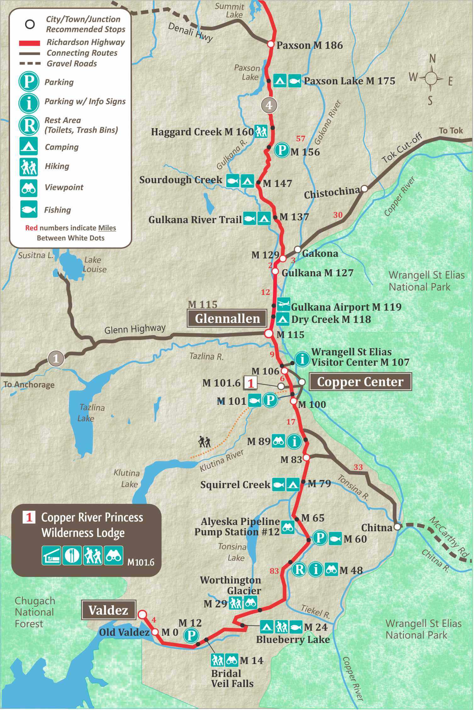
At mile 83 of the Richardson Highway you can turn on the Edgerton Highway to Chitna at the edge of the Wrangell St-Elias National Park. You can drive from Chitna to Kennicott and McCarthy, but the road is rough, and it’s not recommended. We suggest taking a flight from Chitna or Glennallen into McCarthy with Wrangell Mountain Air.
Copper Center
Copper Center is famous for it’s fishing. It’s a small community with plenty of visitors each summer who come to fish for massive King Salmon.
Glennallen
Glennallen, at mile 115 is the junction with the Glenn Highway to Anchorage. Anchorage is 187 miles from the the junction with the Richardson Highway. Glennallen saw an influx of gold seekers headed for the Klondike Gold Fields in 1898. This alternate route to the Klondike was chosen to avoid tariffs that were being charged by the Canadian Government, but it failed as the gold seekers still had to enter Canada to get to Dawson City.
Tok Cut-off Highway
The Tok Cut-off is at mile 129 of the Richardson Highway. This 125 mile road connects to Tok, Alaska and the Alaska Highway.
Denali Highway
The Denali Highway starts at Paxson, mile 186 of the Richardson Highway. The 135 mile Denali Highway connects to the Parks Highway, 28 miles south of Denali National Park. This highway is mostly gravel and many rental car agencies do not allow their vehicles to drive on the highway.
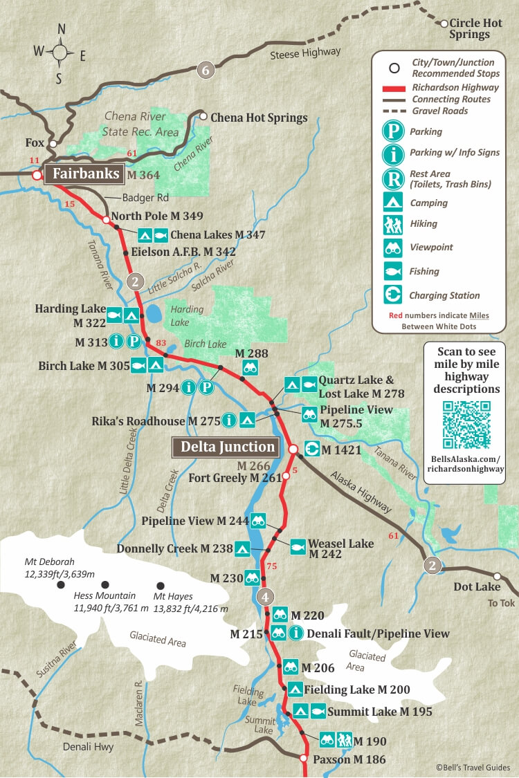
Delta Junction
Delta Junction is famous as being the end of the Alaska Highway. it is located at mile 266 of the Richardson Highway and mile 1422 of the Alaska Highway. Delta Junction was formerly known as Buffalo Center because it was selected as the governments buffalo importation program. Now there is a 90,000 acre plot of land with over 500 free roaming buffalo.
Mile 346.7
North Pole Alaska
At mile 349 Richardson Highway is one of Alaska’s most unique communities: North Pole. Named to honor the home of Santa Claus, this small town embraces the Christmas spirit year round. Be sure to top and visit Santa Claus House and meet his Reindeer.
Fairbanks
Fairbanks is the second largest city in Alaska. It has a lot of amazing attractions for visitors and is not only a destination in the summer but the winter as well. Winter visitors mainly come to see the Northern Lights. Being situated just south of the Arctic Circle, Fairbanks is home to many Northern Lights tours and activities.
Accommodations & Camping in Fairbanks
Things to Do in Fairbanks
Top Scenic Stops Along the Richardson Highway
The Richardson Highway is 364 miles of back-to-back scenery โ but these are the stops worth slowing down for. Listed south to north, Valdez to Fairbanks.
Keystone Canyon (Mile 13โ16)
What makes it special: A narrow canyon carved by the Lowe River, with near-vertical walls rising hundreds of feet above the road. Bridal Veil Falls and Horsetail Falls tumble directly alongside the highway โ you donโt even need to park to see them.
Parking: Pullouts near the falls allow for great viewing.ย
Time needed: 15โ30 minutes for a walk to the base of the falls.
Photo tip: Shoot from the canyon floor looking up for dramatic wall-and-waterfall compositions. Late afternoon light catches the spray.
Best season: May through September; peak flow in June from snowmelt.
Thompson Pass (Mile 26)
What makes it special: Alpine tundra at 2,805 feet, with sweeping views of the Chugach Mountains. Holds Alaskaโs single-season snowfall record. Snow patches last well into July. Avalanche chutes, braided streams, and a raw treeless landscape that feels genuinely otherworldly.
Parking: Designated pullout at the summit.
Time needed: 20โ40 minutes to walk and take in the views.
Photo tip: Wide-angle shots capture the full scale of the pass. In summer, contrast the snowfields with wildflowers.
Best season: Mid-June through August for snow-free road access; winter for backcountry skiing.
Worthington Glacier State Recreation Site (Mile 28.7)
What makes it special: One of the only glaciers in Alaska you can drive directly to. A paved access road leads to a viewing platform; a short trail continues to the glacier face.ย
Parking: Paved lot at the trailhead.
Time needed: 30โ60 minutes.
Photo tip: Include the lateral moraines and outwash plain in the frame โ it shows the glacierโs retreat history. Blue ice detail shots from the face are stunning.
Best season: June through September. Road plowed in winter but can be icy.
Copper Center Overlook (Mile 100)
What makes it special: The small community of Copper Center sits at the confluence of the Klutina and Copper Rivers โ two of the most important salmon rivers in Alaska. The overlook gives a view over the valley, with the Wrangell Mountains on the southern horizon. This is home to some of the best salmon fishing in the state.ย
Time needed: 20โ30 minutes for a quick visit or stay overnight and fish.
Photo tip: Best in morning light facing southeast; the Wrangells catch alpenglow at both ends of the day.
Best season: June through August for clearest mountain views.
WrangellโSt. Elias Views (Mile 83โ130 Corridor)
What makes it special: The WrangellโSt. Elias National Park is the largest in the US, and this stretch of the Richardson gives the best roadside views of the range. Mt. Drum (12,010 ft), Mt. Wrangell (14,163 ft โ an active volcano), and Mt. Blackburn (16,390 ft) are all visible on a clear day.
Parking: Multiple informal pullouts through this corridor.
Time needed: Stop whenever skies clear.
Photo tip: Shoot with the highway or pipeline in the foreground for scale.
Best season: June through August; spring and fall for clearest skies.
Gulkana River Area (Mile 126โ130)
What makes it special: The Gulkana River is one of Alaskaโs most popular fly-fishing rivers for sockeye salmon. The river also offers excellent wildlife viewing. It’s not unusual to see bears fishing, eagles overhead or beavers in the side channels.
Parking: Gulkana River BLM Recreation Site has a formal parking area and boat launch.
Time needed: 1โ2 hours if you want to fish or hike the bank.
Photo tip: Wildlife activity peaks in July and August during the salmon run.
Best season: July to August for salmon and wildlife.
Donnelly Creek Recreation Area (Mile 238)
What makes it special: A BLM campground set along a fast creek with views of the Alaska Range and a nearby WWII-era gun emplacement. Caribou from the Delta herd are frequently spotted nearby.
Parking: Campground parking area.
Time needed: 30โ45 minutes, longer if camping.
Photo tip: Alaska Range reflections in the creek at golden hour.
Best season: June through September.
Rikaโs Roadhouse at Big Delta State Historical Park (Mile 275)
What makes it special: A beautifully preserved 1909 roadhouse that once served gold rush travellers, military personnel, and early automobile adventurers crossing the Interior. The site includes historic farm buildings, a sled dog kennel, and interpretive displays. The Delta River crossing here was the last major barrier for early travellers.
Parking: Formal lot at the park entrance.
Time needed: 1โ1.5 hours.
Photo tip: The main roadhouse building photographs beautifully against the spruce forest backdrop.
Best season: May through September (park open seasonally).
North Pole, Alaska โ Santa Claus House (Mile 349)
What makes it special: North Pole is named exactly as it sounds โ a community that leans fully into the Christmas theme year-round. Streets have names like St. Nicholas Drive Lane and Mistletoe Drive. Santa Claus House is the anchor: a large shop with reindeer on the property and a life-sized Santa statue.
Parking: Ample parking at Santa Claus House.
Time needed: 30โ45 minutes.
Photo tip: The exterior of Santa Claus House is photogenic any time of year โ festive decorations donโt come down.
Best season: Year-round; busiest in summer with Alaska visitors.
Richardson Highway Road Reality Guide
The Richardson Highway is paved end-to-end and generally well-maintained โ but 364 miles of Alaska driving requires more preparation than most road trips. Hereโs what travelers need to know.
Thompson Pass Weather: Expect the Unexpected
Thompson Pass is one of the most weather-volatile places in Alaska. Conditions can go from clear sunshine to dense fog or a whiteout in under an hour. Even in July, the pass can receive new snow. In early and late season (May, SeptemberโOctober), the pass can often see snow and ice on the road surface.
Before driving south from Glennallen, check current conditions at 511.alaska.gov. If visibility is low at the pass, itโs worth waiting it out in Glennallen.
Fuel Planning: Know the Gaps
The Richardson Highway has regular fuel stops. The most critical gap for most travellers runs between Glennallen (Mile 115) and Delta Junction (Mile 266) โ roughly 150 miles with limited fuel options. Fill up at Glennallen before heading north, and at Delta Junction before heading south. Valdez has full services at Mile 0.
Winter Driving Hazards
Winter driving on the Richardson is demanding. Ice forms quickly on the elevated sections near Thompson Pass, and drifting snow can reduce visibility significantly. Avalanche zones on the south side of the pass are marked.Use winter tires or studded tires or chains, carry an emergency kit.. Cell service is non-existent through most of the middle section of the highway.
Summer Construction and Road Surface
Summer road construction is common on the Richardson โ the freeze-thaw cycle creates new damage every spring. Flag personnel control single-lane traffic through work zones; expect waits of 10โ30 minutes in active construction areas. Check 511.alaska.gov for current flagging locations.
Even outside construction zones, the pavement has frost heaves and bumps โ particularly on the section between Delta Junction and Paxson. RVs and vehicles towing should maintain conservative speeds on this stretch.
Cell Service on the Richardson Highway
Reliable cell service exists only in Valdez, Glennallen, Delta Junction, and Fairbanks. Expect no signal for most of the 364-mile route.
Richardson Highway FAQS
Is the Richardson Highway Paved?
Yes the Richardson Highway is paved for the entire drive from Valdez to Fairbanks.
What is there to see between Fairbanks and Valdez?
There is plenty to see and do on this scenic drive on the Richardson Highway.ย
- Stop at Santa Clause House in North Pole, Alaska.
- Visit the end of the Alaska Highway marker in Delta Junction.
- Explore Wrangell St-Elias National Park and visit Kennicott and McCarthy ghost towns.
- Go fishing for massive King Salmon in Copper Center.
What mile of the Richardson Highway is Delta Junction?
Delta Junction is at mile 266 of the Richardson Highway.
How long is the Richardson Highway?
The Richardson Highway is 364 miles long.
When was the Richardson Highway Built?
The Richardson Highway began as a pack trail in the late 1800’s for gold seekers. It was upgraded to a wagon road in 1910 and made suitable for vehicles in 1920. It was finally paved in 1957. The Richardson Highway is known as Alaska’s first highway.
Who is the Richardson Highway Named after?
The Richardson Highway was named after Major Wilds P. Richardson, who was the Alaska Roads Commissioner
What are the Richardson Highway Road conditions?
The Richardson Highway is generally in good condition, but it still has bumps and rough patches, so drive cautiously. For the most current road conditions, visit: https://511.alaska.gov/
Map of The Richardson Highway in Alaska
The Richardson Highway maps below show the highway in 2 sections. The first map shows the beginning of the highway at Valdez (mile 0) up to Paxson, which is the start of the Denali Highway.ย
The second map of the Richardson shows from Paxson to Delta Junction and on to Fairbanks. Delta Junction is the end of the Alaska Highway. From Delta Junction to Fairbanks, the Highway number changes from Highway #4 to Highway #2.


