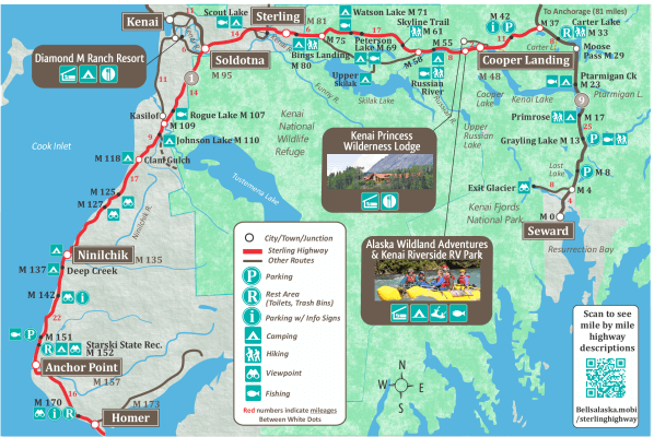
Sterling Highway Driving Highlights.
Kenai National Wildlife Refuge
The Kenai National Wildlife Refuge on the Kenai Peninsula is a vast wilderness area encompassing over 2 million acres. It was established in 1941 by the U.S. Fish and Wildlife Service and serves as a crucial habitat for diverse wildlife species. The refuge features rugged mountains, glaciers, pristine lakes, rivers, and boreal forests.
Wildlife in the refuge includes moose, black bears, brown bears, caribou, wolves, lynx, beavers, and river otters. Birdwatchers will delight in the refuge’s more than 220 species. These include trumpeter swans, sandhill cranes, bald eagles, peregrine falcons, and a variety of waterfowl.
The Kenai National Wildlife Refuge offers a range of recreational activities to visitors including hiking it many trails and canoeing and kayaking on the refuge’s lakes and rivers. Fishing in the numerous lakes and rivers offers opportunities to catch salmon, trout, and Dolly Varden. The headquarters for the Refuge is in Soldotna. When driving to Homer, turn right on Funny River Road and then left on Ski Hill Road.
Kenai River & Kenai Lake
The majestic Kenai River is world renowned for its salmon fishing. The Upper Kenai River river flows from Kenai Lake to Skilak Lake. From there the Lower Kenai River flows down to Cook inlet at the City of Kenai. The upper Kenai River runs through Kenai Canyon and is a popular river rafting area. The lower Kenai River is wider and slower, and a mecca for fishing.
Quartz Creek Recreation Area – Mile 44
One of the main attractions of the Quartz Creek Recreation Area is gold panning. This area was historically significant during the Alaska Gold Rush, and remnants of old mining operations can still be found. Visitors can try their hand at recreational gold panning, sifting through gravel and sand in search of gold flakes or nuggets. The recreation area features a designated panning area along Quartz Creek. Panning equipment is available for rent from local vendors, and experienced staff members can provide guidance and assistance to beginners. The Quartz Creek Recreation Area also offers camping and day-use area for picnicking. Campsites are equipped with picnic tables, fire rings, and access to restroom facilities. There are also hiking trails nearby.


K Beq Interpretive Site – Mile 52.5
In 1984 Archaeologists discovered Indian and Eskimo graves along with prehistoric artifacts near Mile 55 of the Sterling Highway. Most recently the investigative focus has been on an area near present day Cooper Landing known as Sqilantnu, which roughly translates to “the grocery store.” The Chugach National Forest has partnered with the Kenaitze Indian Tribe to preserve and protect the K’Beq’ “footprints” interpretive site. You can experience the traditions and culture by participating in interpretive walks with tribal members.
Russian River Campground – 52.5
Russian River Campground has camping and day-use sites. 84 Sites with toilets, water, firepits. Fee area. There are a number of hiking trails in the area. Reserve campsites by calling 877-444-NRRS or visit www.recreation.gov. There is a boat launch at mile 55 at the Russian River Ferry.
Skilak Lake Road
The Skilak Lake Road branches off the Sterling Highway and leads to Skilak Lake, a popular spot for boating, fishing, and camping. This loop road starts at mile 58 of the Sterling Highway and returns at mile 75. The area surrounding the lake is rich in wildlife.
Soldotna
The bustling city of Soldotna is hub for Kenai Peninsula activities. It offers all the amenities visitors need to stock up on groceries and fuel. It also has many restuarnats and accommodations options. The Kenai River runs through the heart of Soldotna, so you’re never far from incredible fishing opportunities.
City of Kenai
As you enter Soldotna, take the Kenai Spur Highway at the Soldotna Y (The first lights in Soldotna when driving towards Homer). This 11 mile spur road leads to the City of Kenai on the shores of Cook Inlet.
Diamond M Ranch Resort
Diamond M Ranch Resort offers a variety of cabins and historical suites. Located between Kenai & Soldotna, close to the famous Kenai River, with easy day trips to Homer & Seward. It’s the perfect “home-base” during your Alaskan adventure. Wi-fi, showers, freezers, laundry, BBQ, fire pits, picnic tables, fish cleaning stations, wildlife viewing, socials, charters & tours. Take Kalifornsky Beach Road

Kasilof River State Recreation Site – Mile 109.5
Located on the banks of the Kasilof River, this recreation site is ideal for fishing, camping, and picnicking. Anglers can try their luck at catching salmon, steelhead, and trout while enjoying the serene surroundings.
Johnson Lake State Recreation Area – Mile 110
A short detour from the highway takes you to Johnson Lake, where visitors can enjoy camping, canoeing, and fishing. The area is known for its scenic beauty, and hiking trails offer stunning views of the surrounding mountains.
Cook Inlet
As you travel along the Sterling Highway, the breathtaking Cook Inlet unfolds before you. This vast body of water is home to diverse marine life and provides opportunities for boating, wildlife viewing, and photography.
Clam Gulch State Recreation Area – Mile 117
Located along the shores of the Cook Inlet, Clam Gulch offers beachcombing and clam digging activities. Visitors can explore the tidal flats, search for treasures, and witness stunning views of the coastline.
Ninilchik View State Campground – Mile 135
This campground provides panoramic views of the ocean and the village of Ninilchik. With its serene atmosphere and convenient access to fishing and outdoor recreation, it’s an ideal spot to relax and enjoy the natural beauty of Alaska.
Anchor Point
As the most westerly point on the North American continent accessible by road, Anchor Point offers panoramic vistas of the coastline and the Cook Inlet. It’s a popular spot for fishing and beachcombing
Homer
Often referred to as the “Halibut Fishing Capital of the World,” Homer attracts anglers from around the globe. This vibrant town also offers art galleries, seafood restaurants, and the famous Homer Spit—a long, narrow strip of land extending into Kachemak Bay. Kachemak Bay is known for its stunning wildlife, and opportunities for fishing, kayaking and boating.