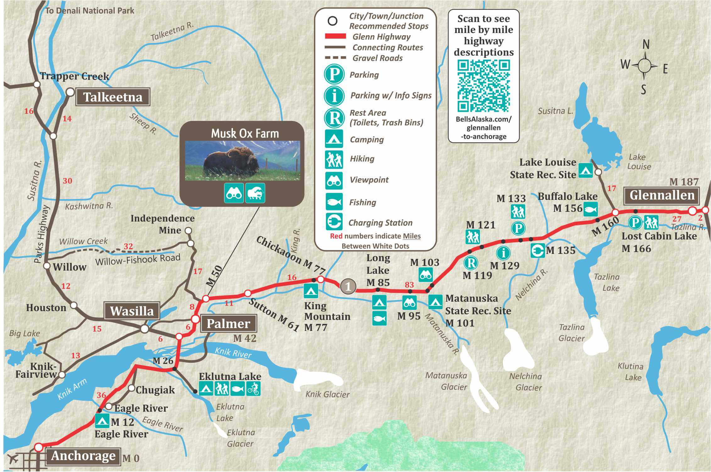
Glenn Highway Highlights
Anchorage
Mile 0 of the Glenn Highway is at the Junction with Ingra Street in downtown Anchorage. Anchorage is the largest city in Alaska and more than 40% of Alaska’s population lives in Anchorage.
Palmer
Palmer is in the Matanuska Valley and is famous for it’s rich farming soil that produces world-record sized vegetables. It is also home of the annual Alaska State Fair, every August.

Mile 50

The Musk Ox Farm practices gentle, low-stress animal husbandry while raising musk oxen for their incredible underwool called “Qiviut.” Qiviut is 8 times warmer than wool and softer than cashmere.
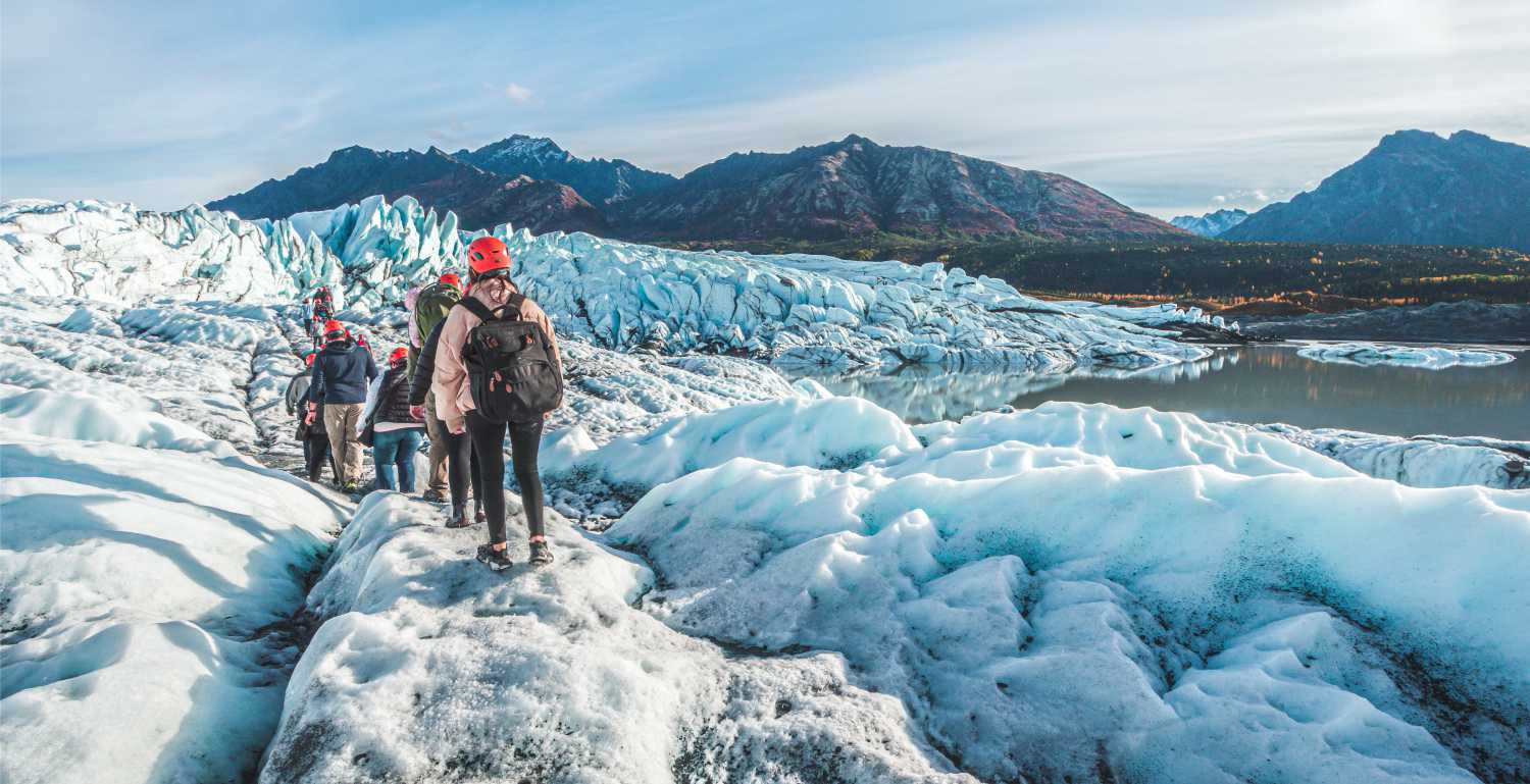
Matanuska Glacier
The Matanuska Glacier is Alaska’s largest glacier accessible by car. The glacier can be accessed at Glacier Park at Mile 102 of the Glenn Highway, two hours east of Anchorage. Access is via a private road at Mile 102.
At Mile 101 on the Glenn Highway you’ll find the Matanuska Glacier State Recreation Site. The recreation site has 6 campsites and a Trail that leads to glacier viewing platforms. There is no access to the glacier from the recreation site.
Lake Louise State Recreation Area
Turn off the Glenn Highway at Mile 159.8 of the Glenn Highway and take the Lake Louise Road 19 miles north to reach Lake Louise. This area is a big draw for local Alaskan’s looking to get away for the weekend. Activities include fishing, boating, jet skiing, birding, and wildlife viewing.
There is a campground at Lake Louise Recreation Area with 67 sites, a picnic area, boat launch and a beach.
There are two lodges on Lake Louise with restaurants.
Glennallen
Glennallen is at the end of the Glenn Highway. It is known for its outstanding scenery and great fishing. Once a stop on the way to the Klondike for some prospectors looking to avoid the tariffs of the more traditional route through Skagway and the Chilkoot Pass. The modern day town of Glennallen really came to be as a construction camp for the building of the Glenn Highway in 1940.
189
Junction of Glenn Highway and Richardson Highway.
Copper Valley Visitor Center
At the junction of the Glenn and Richardson Hwys, beside the Hub of Alaska. www.coppervalleychamber.com

187
Glennallen is known for its outstanding scenery, great fishing and of course, its friendly people. It is located in the Copper River Basin, at the junction of the Glenn and Richardson Highways.


186
Moose Creek.
176.8
Parking; Historic info signs with views of Mount Drum, Mount Sanford and Mount Wrangell, a semi-active volcano.
174.8
Parking.
173
Tolsona Creek. Parking. Camping, RV Park and Lodge.
170.7
Tolsona Lake Resort.
169.1
Parking, Mae West Lake reached by 1/2 mile trail from highway.
166
Parking, Lost Cabin Trail, 2 mile trail to Lost Cabin Lake. Popular berry picking area-blueberries, lowbush cranberries, wild raspberries.
162.3
Parking.
162
Tex Smith Lake. Lake stocked with rainbow trout.
160
Lake Louise Junction, and side road to Lake Louise, an easy 16 mile road, Lake Louise is a wonder of glaciers, snowcapped mountain ranges and wildlife.
The fishing is good year round, but best after break-up in June. Lake is part of 50-mile-long lake system with excellent fishing for lake trout, Arctic grayling, whitefish, burbot. Road to lake traverses the caribou’s winter range, a prime late-season hunting area. Several small lakes along the way (most within a mile of the road) offer good fishing-grayling, rainbow, silver salmon. During late August and early September, there is good berry picking here.
Lake Louise State Recreation Area has 50 camp sites, toilets, water, hiking trails and fishing. Handicap accessible.
156.2
Buffalo Lake. Stocked lake.
156.1
Tazlina Airstrip.
155.8
Arizona Lake.
155.5
Parking.
155.2
Gergie Lake.
154
Mendeltna.
152.9
Mendeltna Creek bridge and rest area, toilets. Grayling and Dolly Varden.
149
Nelchina.
143
Nelchina Lodge.
137.3
Little Nelchina River.
135.9
Parking.
135
Slide Mountain RV Park and Cabins.
133
Parking. John Lake trailhead.
131
Large gravel parking lot used by ATVers, hikers and hunters. Old Man Creek Trailhead.
129.3
Parking at Eureka Summit. 3,322 ft./1013 m; Historical sign on the Gold rush centennial. Highest point on Glenn Highway. Nelchina Glacier lies to southwest.
128
Eureka Lodge.
126.4
Nelchina River trailhead.
123.3
Belanger Pass trailhead.
122
Tahneta Pass, elevation 3,000 ft., large parking area. Liela Lake good grayling fishing reached by short hike.
121.4
Parking, trailhead.
120.2
Scenic viewpoint of Chugach Mountains.
118.3
Rest area, toilets. Trailhead
118.2
Trail Creek.
117.1
Parking with excellent view of the Chugach Mountains. Camp Creek Trailhead.
115.6
Scenic View.
113.5
Sheep Mountain Lodge established in 1946, has been serving travelers for over 70 years. 11 cabins, 12 miles of hiking trails, sauna and hot tub. 907-745-5121.
113
Sheep Mountain Airstrip.
112.8
Parking and picnic table. Good view of Sheep Mountain.
112.1
Gypsum Creek.
109.6
Grand View Café & RV Park. Enjoy breathtaking panoramic mountain views and wildlife viewing from your full service RV site. Relax in the log Cafe, where home style meals, pizza, espresso and beer and wine are served daily. 907-746-4480
109.5
Tundra Rose Guest Cottages has private, quality log cottages in a rural setting, each with mountain and Matanuska Glacier views! Gas fireplaces, kitchenettes, decks, patios with fire pit, cable TV and wildlife viewing. 907-745-5865
If you are heading towards Glennallen there are numerous small parking areas between mile 54 and mile 110.
108.3
Parking
107.8
Parking with an excellent view of the Matanuska Glacier.
107
Caribou Creek and trail. Good rock hounding. Trail leads behind Sheep Mountain.
104.3
Parking.
102.2
Long Rifle Lodge.
102
Turn-off to Glacier Park Resort. Private campground.
101.7
Parking with Viewpoint.
101.1
Matanuska Glacier State Recreation Site. 12 camp sites, water, toilets. Trails along bluff give excellent views of Matanuska Glacier. Activites include: hiking, Glacier trekking & river rafting. There is no access to Matanuska Glacier from the Recreation site.
99.7
Scenic view of Matanuska Glacier.
96.6
Hicks Creek, parking at both ends of bridge.
94.8
Parking with view over the Matanuska River.
94.6
Victory Road.
90.7
Parking at Puriton Creek and trailhead. Blueberry patches. Watch for bear and moose.
89
Puritan Creek.
87.5
Parking at Weiner Lake & picnic site. Fishing for rainbow and grayling.
85.3
Long Lake State Recreation Site, parking, boat launch, Stocked with rainbow and Arctic char.
84.1
Parking.
80.8
Parking
78.3
Parking with view of King Mountain.
78
Chickaloon River and Canyon. Parking at both ends of bridge.
77.5
Parking beside the Matanuska River
76.8
Chickaloon.
76.7
King Mountain State Recreation Site on the banks of the Matanuska River. 22 camp sites, water, toilets. Fee area.
74.5
Parking beside river.
74.3
Parking.
69
Parking.
66.6
King River Bridge, parking at both ends of bridge.
62.8
Parking.
62.4
Granite Creek Bridge. Fishing for Dolly Varden and trout.
61.6
Sutton Post Office.
61
Sutton, small highway community with amenities. The Jonesville Mine Road which turns off the Glenn Highway at the general store leads to former site of the Eska & Jonesville Coal Mines-good area for fossil hunting.
60.8
Eska Creek Bridge.
58.7
Parking with viewpoint.
54.6
Moose Creek.
54.5
If you are heading towards Glennallen there are numerous small parking areas between mile 54 and mile 110.
50.1
Musk Ox Farm and Gift Shop.
49.9
Parking with view.
49.5
Junction. Willow Creek-Fish Hook loop road. A scenic loop road that connects Willow and Palmer via Hatcher Pass. It is approximately 49 miles long, about 14 miles of which are gravel. The road is steep and winding and the gravel portion can be rough. It is not recommended for RV’s or towed vehicles to travel between Willow and Hatcher Pass.
Independence Mine State Historical Park at Hatcher Pass is operated by Alaska State Parks and offers glimpses of what life was like in the Gold Rush. A guided tour will take you inside some of the mining camp’s historic buildings where you’ll discover the Independence Mine story. Open daily from mid June through Labor Day from 11am to 6pm. Best access is from Palmer as the road is paved and open year-round as far as Hatcher Pass.
42.1
Arctic Avenue, east is exit for Palmer, it is also the Old Glenn Highway, alternate route to Anchorage.
42
Palmer Alaska. Surrounded by Alaska’s rich history and lore, Palmer is a quiet town, with a population of 6,000.
Palmer Museum and Visitor Center
In the rustic log cabin downtown. Items from Palmer’s pioneer days are displayed in the museum. palmermuseum.org

40.2
Main entrance to Alaska State Fairgrounds.
36.4
Matanuska Lakes State Recreation Area. This state recreation area is excellent for fishing, hiking and biking. Access to Matanuska, Canoe, Irene and Long Lake. All are stocked by the department of Fish and game. 6 campsites, Day-use area with toilets, water, boat launch and picnic sites
35.5
Junction of the Parks Highway and Glenn Highway. From here, the Parks Highway goes north to Denali National Park and Fairbanks and the Glenn Highway continues south to Anchorage and is divided highway from the junction to Anchorage.
31.6
Matanuska River.
30.6
Knik River Access. Access to Reflection Lake trail, a 0.9 mile loop trail around the lake. Boardwalk over wetlands ideal for wildlife viewing.
29.9
In the next mile 3 bridges cross the Knik River.
29.1
Old Glenn Highway.
26.5
Overpass with exits on both sides of highway to Eklutna and Thunderbird Falls.
Eklutna Campground has 50 camp sites, picnic sites and shelters, toilets, water, and hiking trails. Eklutna Lake is the largest lake in Chugach State Park. Good fishing for Dolly Varden and rainbow. Campground is in mountain setting with cottonwood and spruce trees, fresh water streams, springs, and glacial river. Twin falls near parking area at road’s end (13 miles). Short hike to Eklutna glacier at far end of canyon–this is a dangerous area. Do not climb on the glacier without proper equipment, knowledge, and guides. Side road (opposite Eklutna Recreation road) leads to old Eklutna Village with Russian Orthodox Church and Indian Cemetery.

25.2
Thunderbird Falls exit for northbound traffic only and access to Eklutna Road. Thunderbird Falls is about 1 mile from the highway.
24.5
Southbound exit for Mirror Lake Municipal Park.
23.6
Mirror Lake Municipal Park. Northbound exit only. Picnics shelters, swimming, boating, fishing, toilets.
23
North Peters Creek exits both sides of highway.
21.6
South Peter’s Creek exits both sides of highway.
21.3
Bridge over Peter’s Creek.
20.7
North Birchwood Loop Road exits both sides of highway. East to Chugiak follow the Old Glenn Highway to Eagle River.
17.9
South Birchwood Loop Road.
15.5
Old Glenn Highway.
13.6
Exit for the twin communities of Chugiak-Eagle River.
13
Bridge over Eagle River.
12
Hiland Road exit to Eagle River Campground. Access via short side road. 57 camp sites, picnic sites and shelters, toilets, water and fishing. This camping area is usually crowded. There is a camping limit of 4 days and a camping fee. One-half of the campsites are available by reservation – 907-694-7982 or make reservations on-line at www.lifetimeadventures.net
7.5
Southbound exit to Joint Base Elmendorf- Richardson and Arctic Valley Road. Hiking in Chugach State Park with trailheads at mile 6.3 and mile 7 of Arctic Valley Road.
6.1
Northbound exit to Joint Base Elmendorf- Richardson and Arctic Valley Road. Hiking in Chugach State Park with trailheads at mile 6.3 and mile 7 of Arctic Valley Road.
4.4
Muldoon Road. City bypass route to New Seward Highway and the Anchorage International Airport.
3
Boniface Parkway. Russian Jack Springs Park. Turn north for Elmendorf AFB.
1.9
Bragaw Street.
0
Anchorage – Junction with Ingra Street. Embraced by mountain ranges and warmed by a maritime climate, Anchorage, Alaska, is alive year round with adventure, recreation, seasonal festivities, sporting events and more.
Log Cabin Information Center
Operated by Visit Anchorage, this is and the Info Center at the Ted Stevens International Airport offer tons of great information about Anchorage and the entire state of Alaska. www.anchorage.net
Hotels & Camping


Things To Do


Dining & Services