There are several ways to drive to Alaska, but if you’re looking for the Best RV Route to Alaska, here it is. I would consider this the ultimate Alaska road trip, which includes the Canadian provinces of British Columbia and Alberta and the Yukon Territory.
It hits all the highlights, two national parks and includes long drives, ferry rides, the Alcan Highway, Klondike Highway and Top of the World Highway. It is not the most direct route. It is the best route!
Just make sure you plan enough time to stop along the way and enjoy the many attractions of each amazing destination along the way.
The best way to start your route to Alaska is in British Columbia, Canada. If you’re driving north from Washington State, a good place to enter Canada is at the Oosyoos Border crossing. This will lead you through the beautiful interior of BC and the resort town of Kelowna and Vernon, on your way to stunning Banff National Park.
The best time to take this epic RV trip to Alaska is sometime between June and September. This will ensure all the northern roads and amenities are open.
Click here For a list of the best RV Parks in Alaska
It is a good idea to be aware of current Road Conditions. Here are some useful links:
Here are the highlights this 5,600 km (3,480 miles) epic road trip will hit:
- Banff & Jasper National Parks
- Dawson Creek, BC
- Alaska Highway
- Mucho Lake Provincial Park
- Liard River Hot Springs
- Watson Lake, Yukon
- Whitehorse, Yukon
- Skagway, Alaska
- Haines, Alaska
- Klondike Highway
Highlights of the Best RV Route to Alaska
Banff National Park
Banff is Canada’s first national park and has one of the most impressive landscapes in the world. Banff is part of the Canadian Rocky Mountain Parks UNESCO World Heritage Site. Banff encompasses 6,641 square kilometres of mountainous terrain, with many glaciers and ice fields, dense forest, and alpine landscapes.
From Banff, head north on the world-renowned Icefields Parkway. This stunning 232 km drive from Lake Louise to Jasper will showcase the beautiful Rocky Mountains and their high mountain peaks, sweeping valleys and numerous icefields and glaciers.
Jasper National Park
Jasper National Park is the largest national park in the Canadian Rockies. As part of UNESCO’s Canadian Rocky Mountain Parks World Heritage Site, visitors will not want to miss this stunning park on their route to Alaska. The landscape covers an expansive region of rugged backcountry full of wildlife, home to some of North America’s healthiest populations of grizzly bears, moose, and elk.
From here, take Highway 16 west to Prince George.
Prince George, BC
Located near the geographic centre of BC, Prince George is the Gateway to the North. Located at the junction of Highways 16 & 97 and the confluence of the Fraser and Nechako rivers, you’ll find all the amenities the largest BC city on the Yellowhead has to offer. While visiting Prince George, you will find top notch accommodations, restaurants, and unique gift stores.
From Prince George, head north on Highway 97 (The John Hart Highway) to Chetwynd and Dawson Creek.
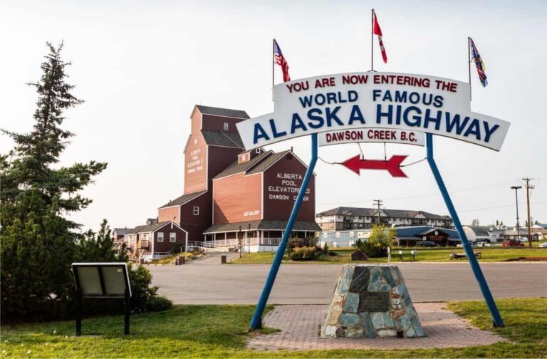
Dawson Creek, BC
Dawson Creek is Mile 0 of the Alaska Highway, also known as the world-famous Alcan Highway! Dawson Creek has a population of about 12,000 people and is considered the starting point for most Alaska bound adventurers. The Dawson Creek Visitor Information Center is the best place to visit before you continue north. It has excellent resources for planning your journey, it also has an incredible museum. The Dawson Creek Art Gallery is located next door, in the renovated grain elevator. At the edge of the parking lot, you’ll also find the Mile 0 Cairn and the famous Alaska Highway Sign. A perfect place for a photo op!
Heading North towards Fort St. John, visitors can stop to explore the famous curved wooden bridge at Kiskatinaw Provincial Park and the town of Taylor. The bridge was closed to crossings in 2023 so it may require a quick 5 km trip in and out on the Old Alaska Highway. When the bridge is open, it is a loop road that connects back with the new Alaska Highway at km 34.
Fort St John, BC
Located in the heart of the majestic Peace River country, only 75 km north of Dawson Creek. St. John is British Columbia’s oldest non-aboriginal settlement, and its pioneer spirit is alive and well today.
Fort St. John began in 1794 as a trading post, in 1928 it was established as a community and in 1942 the Alaska Highway was built. This friendly, small town has lots of big city amenities, creating a fantastic atmosphere for many to call home. There are plenty of unique shops and it offers a rich concentration of cultural and outdoor activities.
The drive from Fort St John to Fort Nelson is 380 km and with plenty of camping, fishing, and hiking opportunities. If you have time to spare, this section of the Alaska Highway offers excellent places to rest and enjoy the wilderness of BC.
Fort Nelson, BC
Fort Nelson was established first as a Hudson Bay Trading Post in 1805 and remained a small outpost until the US Army arrived in early 1942 to build the Alaska Highway. Tourism has become a very important part of the local economy as Fort Nelson is a major transportation hub and the largest city in the Northern Rockies Regional District. There are regularly scheduled flights with Central Mountain Air, it is the northern railhead of CN Rail, and the world-famous Alaska Highway doubles as Main Street.
From Fort Nelson, the highway heads as much West as it does North, winding its way through the very northern section of British Columbia, toward the Yukon. There are incredibly beautiful stops along this section of the route to Alaska, including Stone Mountain Provincial Park, Muncho Lake and Liard River Hot Springs.
Muncho Lake
Driving along the shore of this massive jade green alpine lake is oddly reminiscent of Jasper National Park before the crowds. Canoeing and paddling Muncho Lake is a favorite pastime with rentals available at local businesses, like Northern Rockies Lodge. There is lodging and camping available in Mucho Lake allowing visitors to relax and enjoy one of the most beautiful spots on the route to Alaska.
Liard River Hot Springs
Liard River Hot Springs Provincial Park is a popular destination for highway travellers. Enjoy a walk along the boardwalk to the mineral pools and then soak in the different pools of varying temperatures. There is a day-use area as well as camping and lodging at the Hot Springs.
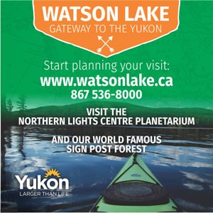
Watson Lake, Yukon
Watson Lake is the first Yukon community encountered by the northbound traveller. A comfortable day’s drive from Fort Nelson or Whitehorse makes it a popular stopover point. There are several hotels, campgrounds and a number of interesting tourist attractions including the very unique Signpost Forest and Northern Lights Centre.
The Signpost Forest is Watson Lake’s most famous attraction. It was started in 1942 by Carl Lindley, a homesick American GI, while working on the Alaska Highway. When repairing a directional post, he decided to add a sign for his hometown of Danville, IL, and inadvertently started this enormous collection of signs. The Signpost Forest is one of The Yukon’s most famous landmarks with over 100,000 unique signs. It is still being added to each year by visitors who bring or make a sign.
Teslin, Yukon
The Village of Teslin, Yukon is on the shores of Nisutlin Bay on Teslin Lake. The name Teslin is taken from the Tlingit word ‘Teslintoo’, meaning, “long narrow waters” referring to Teslin Lake, which is 125 km (78 miles) long. The Teslin Tlingit people have a long and interesting history that is explored at the Teslin Tlingit Centre on the north end of town. In town, stop at the Nisutlin Trading Post for food, fuel or to stay the night.
Whitehorse, Yukon
Over two-thirds of the Yukon’s residents live in Whitehorse, which has a year-round population of about 36,000. Residents enjoy unparalleled access to the surrounding wilderness and outdoor adventure of Canada’s Yukon Territory.
Whitehorse played a pivotal role in the Klondike Gold Rush, as a supply centre for stampeders headed to Dawson City. After the war, and the building of the Alaska Highway, Whitehorse maintained its importance as a transportation and communications centre for the Yukon. On April 1, 1953, the capital of the Yukon territory was officially transferred from Dawson City to Whitehorse.
There are a lot of amazing things to do in Whitehorse, so plan a few days here to relax and enjoy them.
Leaving Whitehorse, it’s time to leave the Alaska Highway, and head South on the Klondike Highway toward Skagway. But first, take time to stop in Carcross and explore what this small Yukon town has to offer.
Carcross, Yukon
The Tagish people call this area Todezzane, “wind blowing all the time” and the Tlingit call it Naataase Heen, “water running through the narrows”. In 1899, the community was officially named Caribou Crossing, referring to the spot where the local woodland caribou herd crossed the narrows. In 1906 it was renamed Carcross. This small town played a critical role in the Klondike Gold Rush. After Stampeders crossed the Chilkoot or White Pass, they would build rafts here to float down the Yukon River to Dawson City. Soon, the trip from Skagway to Carcross got exponentially easier with the completion of the White Pass & Yukon Route (WP&YR).
80km south of Carcross the Klondike Highway crosses into Alaska, only a few miles north of Skagway.
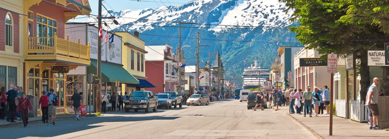
Skagway, Alaska
Skagway, Alaska is the northernmost point in Alaska’s Inside Passage, at the far end of Lynn Canal. In its heyday, Skagway was the boomtown gateway to the Trail of ’98 and the Klondike gold fields. The population has dwindled from 20,000 feverish gold seekers to about 1000 year-round citizens.
Streets once choked with gold-crazed stampeders clamoring to get to the Klondike and strike it rich, are now just as busy with thousands of cruise ship passengers arriving every day during the summer! On a busy ship day, Skagway reverberates with many of the same feelings that must have been present during the Gold Rush.
Skagway is home to the White Pass and Yukon Railroad, the “Scenic Railway of the World.” It is one of Alaska’s most popular visitor attractions and should not be missed. This narrow-gauge railroad is more than a train, it is a ride through history.
Skagway is also the home of the Klondike Gold Rush National Historic Park, which honors the stampeders of the Klondike by protecting the historic buildings and trails of the Gold Rush era. On June 28, 1900, Skagway became the first incorporated city in Alaska.
After exploring the many treasures of Skagway, it’s time to take the 1-hour ferry journey to Haines, Alaska. Haines is only 14 miles from Skagway, but there is no road, and ferry or plane are the only transportation options. Of course, you could drive, but it is more than 500 km on the Klondike Highway, Alaska Highway and Haines Highway. So, we recommend you take the short, scenic ferry ride!
Alaska Marine Highway Ferry to Haines
The Alaska Marine Highway provides year-round ferry transportation throughout Southeast Alaska. The ferry routes taken by the Alaska Marine Ferry are so scenic they are collectively, a National Scenic Byway. All Ferries carry passengers and vehicles and have lounges and observation areas. The journey from Skagway to Haines is only 1 hour and is a very enjoyable experience.
Haines, Alaska
Haines is situated at the upper end of North America’s longest and deepest fjord. It is located at the southern end of the Chilkat Valley, which is home to abundant wildlife and one of the highest concentrations of Bald Eagles in North America. The Chilkoot River offers an amazing opportunity to view both brown bears and black bears. There are great wildlife spotting opportunities in Haines, so allow some time here to explore.
When leaving Haines, you will be taking the 159-mile Haines Highway north, back to the Yukon. The highway was built in 1943 and is now one of Alaska’s best and most scenic highways. The Haines Highway connects to the Alaska Highway in Haines Junction, 150 km from Whitehorse. You will cross back into Canada at the U.S/ Canadian border, 40 miles from Haines.
Haines Junction, Yukon
The highway community of Haines Junction is nestled at the base of the St. Elias Mountains. Visitors can enjoy glacier flightseeing, river rafting, mountain biking, horseback riding, hiking, snowmobiling or cross-country skiing in this small community. Haines Junction is also the headquarters for Kluane National Park.
The 7,000 to 9,000-ft. summits of the Kluane Mountain Range to the west of town contains many of Canada’s highest peaks, including Mt. Logan at 19,550 ft. Flightseeing tours with Rockingstar Adventures is a must do!
The Klondike Highway
Once again, it’s time to change directions. You’re beginning to see that the best route to Alaska is not a straight line!
Head south/east on the Alaska Highway back towards Whitehorse. 12 Km north of Whitehorse turn left onto the Klondike Highway and head north to Dawson City.
The Klondike Highway parallels the route taken by the stampeders heading to Dawson City during the Klondike Gold Rush in 1898.
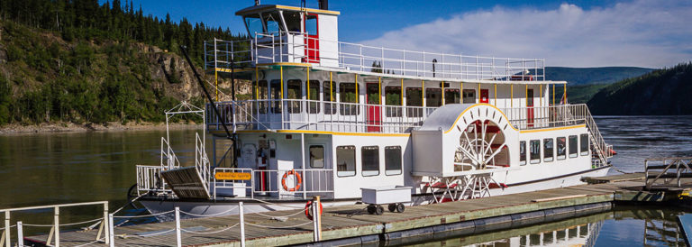
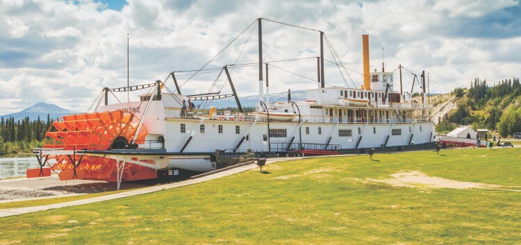
Dawson City, Yukon
George Carmack and his native companions, Dawson Charlie, and Skookum Jim, explored the area around the river the First Nations people called “Tr’ondek”—or Klondike to English tongues. The three lucky prospectors discovered gold on Bonanza Creek on August 16, 1896, marking the beginning of the Klondike Gold Rush!
Thirty thousand prospectors and miners, entrepreneurs, bankers, gamblers, prostitutes, and con artists from every corner of the continent came across snow-covered mountain passes and down the Yukon River to claim their fortune in the Klondike. Most who made the journey found no gold at all. But the hope of striking it rich was not all that mattered. For many of those who made the incredible expedition, the Klondike represented an escape from everyday life and adventure in a new frontier.
Dawson City still represents its frontier spirit well and offers plenty of unique experiences for visitors. Come discover one of the North’s real gems.
Top of the World Highway
The Top of the World Highway is really two highways. In the Yukon the Top of the World Highway is Yukon Highway #9. The Top of the World Highway in Alaska is the Taylor Highway. The Top of the World Highway is 175 miles/281 km and connects Dawson City to the Alaska Highway at the Tetlin Junction (13 miles south of Tok).
The Top of the World Highway is only open from early June to early September. So, make sure your drive to Alaska falls between these months, or you risk having to backtrack.
When leaving Dawson City, you will need to take the George Black Ferry. It crosses the Yukon River, for free, 24 hours a day in the summer. The first 106 km to the border is mostly on a chip-sealed surface with gravel sections. There are a number of scenic overlooks on this part of the highway, so take your time and enjoy driving across the top of the world!
Chicken, Alaska
Chicken is located at mile 66.8 of the Taylor Highway, 78 miles from Tok. The history of Chicken is rich and began with the discovery of gold, on Franklin Gulch, in 1886. The Historic Town of Chicken was a hub of activity for the southern portion of the Fortymile Mining District. Many of the original buildings still stand including “Tisha’s Schoolhouse” made famous by the book “Tisha” about Anne Purdy’s life teaching there in 1927. This is a great place to stop for the night when crossing the Top of the World Highway.
Tok, Alaska
To get to Tok, you will be back on the Alaska Highway. Tok is often referred to as the “Gateway to Alaska,” because it is the first major community in Alaska when heading north on the Alaska Highway. It also intersects with the Tok Cut-off leading to Glennallen. From there travelers can head south to Valdez or west to Anchorage.
The modern community of Tok began as an Alaska Road Commission Camp built for the construction and maintenance of the Alaska Highway. Today the town has a population of approximately 1250. Its economy is based on tourism and for its size, Tok offers more hotel rooms and campsites than any other town in the state.
From Tok, continue north on the Alaska Highway to Delta Junction.
Delta Junction, Alaska
Delta Junction marks the true end of the Alaska Highway. From here, going north or south, you will be traveling on the Richardson Highway, which starts in Valdez and ends in Fairbanks. There is a large commemorative milepost at the visitor center to mark Mile 1422 of the Alaska Highway.
In 1903, during the Fairbanks Gold Rush, what was to become the Richardson Highway, was built from Valdez to Fairbanks via Delta Junction. This trail used a portion of the Valdez Eagle trail made famous by the Klondike Gold Rush. A roadhouse was built at the junction of the Delta and the Tanana Rivers to supply the gold seekers and was the beginnings of this community.
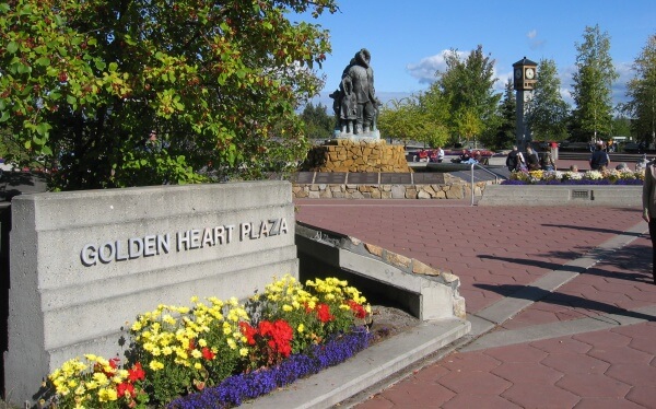
Fairbanks, Alaska
Fairbanks Alaska offers visitors small-town hospitality and a pioneer spirit that will make your stay one to remember. Fairbanks is Alaska’s second largest city in Alaska with a population of 32,000 and a Borough population of almost 100,000, including the nearby military bases.
Fairbanks is the hub for Alaska’s Interior and Arctic and is known for its first-class accommodations and restaurants, museums, concerts, historic sites, Alaska Native culture, and access to the Alaskan wilderness. It is also famous for its incredible long summer days, where the sun never seems to set. In June, Fairbanks sees over 21 hours of sunlight. Of course, in the winter, the opposite is true, and there are very long, dark days. In December, there will be less than 4 hours of daylight in Fairbanks.
Fairbanks is also the home of several world class attractions. The Riverboat Discovery is consistently rated one of the top boat tours in the State and Gold Dredge 8 is also a visitor favorite. The Antique Auto Museum at the Wedgewood Resort has an amazing collection of vintage automobiles, historical photos, and period costumes. Finally, don’t miss The University of Alaska Fairbanks ‘Museum of the North’ as it is one of the best museums in the State.
Fairbanks not only has plenty of things to do in the summer months, but during the winter it is one of the best places in the world to view the Aurora Borealis (Northern Lights). It is near the Arctic Circle, which makes the Northern Lights visible from September to April.
Leaving Fairbanks, it’s time to head south on the Parks Highway to Denali National Park.
Driving the Parks Highway
Over twelve years and $150 million went into the completion of the Parks Highway in Alaska in 1971. The highway travels through 358 miles/576 km of Alaska’s most rugged terrain from Fairbanks to Anchorage.
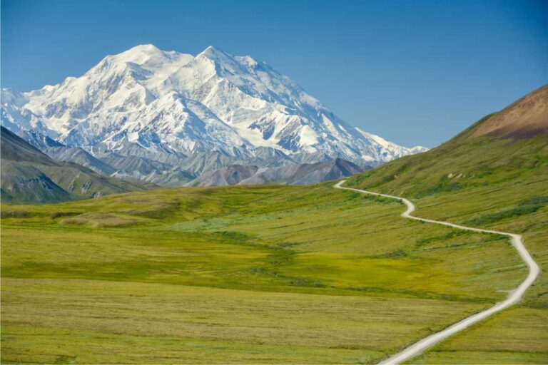
Denali National Park
Denali, the “High One”, is the name the Koyukon Athabaskan people gave the massive peak that crowns the 600-mile-long Alaska Range in Denali National Park. At 20,310 feet, Denali is the highest peak in North America and the number one visitor attraction in the State of Alaska.
Visitors can only drive their car into Denali National Park a short distance. Private vehicles are not allowed past Mile 15 of the Denali Park Road. To see more of the park, most visitors will need to take a shuttle bus. While in Denali, you can choose to go rafting, ziplining, ATVing, Jeep touring, hiking, or camping.
Talkeetna, Alaska
Talkeetna Alaska is a small town 130 miles south of Denali. This is the staging area for most climbing expeditions to Denali but also the most popular town in Alaska to take a flightseeing tour of Denali and the Alaska Range. Visitors can enjoy rafting or jet boat tours of the local rivers or just wander the historic streets of this charming Alaska town.
Talkeetna was established as a mining town and trading post even before Wasilla or Anchorage existed. The Talkeetna and Chulitna Rivers join the Susitna River at the end of Main Street and the town takes its name from an Indian word K’Dalkitnu, meaning, “rivers of plenty.” Talkeetna is at the end of a 14-mile spur road off the Parks Highway. Turn off the Parks highway at mile 99 to reach Talkeetna.
Matanuska-Susitna Valley
The Matanuska-Susitna Valley, known as the Mat-Su, is one of Alaska’s foremost recreation areas. It has over 23,000 square miles of unspoiled mountains, lakes, and glaciers with unlimited opportunity for camping, hiking and adventures.
Palmer and Wasilla are the two largest towns in the Matanuska Valley. The many local farms will convince you this is the state’s agricultural center, yielding almost two-thirds of Alaska’s produce. The fertile area is known for growing huge, award-winning vegetables, many of which can be seen each year at the Alaska State Fair, held in Palmer in the Fall.
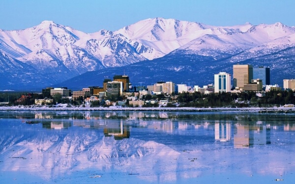
Anchorage, Alaska
Embraced by mountain ranges and warmed by a maritime climate, Anchorage, Alaska, is alive year-round with adventure, recreation, world-class museums, seasonal festivities, sporting events and more.
Recognized as a four-time All-American City, Anchorage is Alaska’s largest city and the hub for Southcentral Alaska.
Anchorage has much to offer the visitor and is an excellent place to headquarter as you explore the myriad of things to do nearby. In summer months, residents enjoy endless hours of fun under the midnight sun.; Flightsee over snowcapped mountains, cruise cobalt waters to see Alaska’s abundant sea life, reel in a wild Alaska salmon right downtown or hike a mountain trail just a few minutes from your door.
To complete the ultimate RV route to Alaska, head south from Anchorage to the Kenai Peninsula. First, take this opportunity to explore the glaciers and scenic vistas of Prince William Sound from Whittier. Then continue south to Seward and the Kenai Fjords National Park. Finally, head to the far end of the Kenai to explore Homer, the Halibut Fishing Capital of the world.
Seward Highway
The 127 mile Seward Highway has been designated a National Forest Scenic Byway. It connects the cities of Anchorage to Seward traveling past saltwater bays, ice-blue glaciers, and alpine valleys. The first 50 miles of the highway twists and turns along the base of the Chugach Mountains, the Chugach National Forest, and the shores of Turnagain Arm.
The 37-foot tides of Turnagain Arm are exceeded only by those in Nova Scotia’s Bay of Fundy. The waters racing out of the inlet expose miles of mud flats and when they return, frequently create a 6-foot bore tide. These bore tides are highest during the equinox and when a very low tide is followed by a very high tide. If your timing is good, you may even see people surfing or kayaking the bore tide for miles!
Just past the Portage Glacier Road (Mile 79), you will enter the Kenai Peninsula Borough – over 25,000 square miles of scenic park lands, glaciers, rivers, and unique communities. Mile 79 is also where you will find the Alaska Wildlife Conservation Center.
You can take the 11-mile Portage Highway to Whittier. The Portage Highway passes through 2 long tunnels. One of which, is the longest shared train/vehicle tunnel in North America at 2.5 miles long.
Whittier
Surrounded by three magnificent glaciers, Whittier is an adventure lover’s paradise. Each summer the 220 residents of this bustling community welcome thousands of visitors arriving by road, cruise ships and ferries. Whittier is the cruise port for Anchorage.
Change came in 2000, when the State of Alaska transformed the existing railroad tunnel into a one-lane, combination highway and railway tunnel. This created the longest combined rail and highway tunnel in North America. This is a toll tunnel, and you can find the current tolls here.
To continue to Seward, you will need to drive the Portage Highway back to the Seward Highway. When you reach Seward, at the end of the highway, you will be met with stunning scenery from this small coastal community.
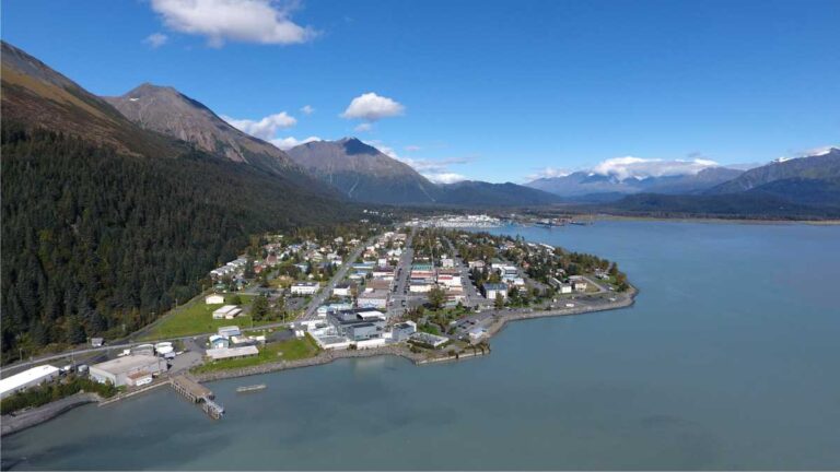
Seward, Alaska
Seward is a charming coastal town. Abrupt mountain slopes cloaked in shaggy summer greens and snow form an impressive backdrop for this progressive city of 2,700 people on the Kenai Peninsula. Known as the “Gateway to Kenai Fjords National Park”, Seward is home to several world-class boat tours that explore the stunning scenery and abundant wildlife of the National Park. The Kenai Fjords National Park is one of the most visited areas in all of Alaska because of its incredible natural wonders and the popularity of Seward as a cruise ship destination.
Nearby Exit Glacier is one of the most visited glaciers in the State and is the only part of the Kenai Fjords National Park that is accessible by road. The area around the glacier is great for a hike.
37 miles north of Seward, the Seward Highway connects with the Sterling Highway which travels southwest to the end of the Kenai Peninsula and accesses the towns of Soldotna, Kenai, Ninilchik, Anchor Point, and Homer.
Soldotna, Alaska
Soldotna is the central hub of the Kenai Peninsula and is located just 150 miles from Anchorage. Unlike most towns in Alaska, which were founded during the gold rushes, Soldotna wasn’t settled until about 1947 by Homesteaders.
Soldotna is famous for its easily accessible fishing. The Kenai River flows right through town and there is excellent fishing from almost anywhere along it’s banks.
Another 80 miles south of Soldotna, you come to the end of the road…Homer.
Homer, Alaska
Homer is located on the shores of Kachemak Bay, surrounded by glaciers and mountains and a home base for great fishing, and kayaking, bear viewing, hiking, foodie and art vacations.
Homer has the unique attraction of the 2nd longest “Spit” in the world. The Homer Spit is a natural geologic phenomenon formed initially by terminal glacial moraine and juts 5 miles out into Kachemak Bay. It is a great jumping-off place for endless adventures in and across Kachemak Bay.
Homer has bear viewing trips to Katmai National Park, home of the famous Brooks River Falls.
The Best RV Route to Alaska: Conclusion
This RV route from BC to the Yukon and through Alaska is probably the best RV route you can take. But it’s certainly not the only one. There are dozens of changes that could be made to suit each individual travelers needs.
There are two destinations in Alaska that are not included on this ultimate Alaska road trip that should be visited. Those are Wrangell St.-Elias National Park and Valdez. These are on the Richardson Highway and could be visited on your return trip from Alaska.
Valdez, Alaska
Valdez Alaska is a beautiful coastal Alaska city, nestled on the shores of Prince William Sound. It has a spectacular mix of tidewater glaciers, forests, and mountains unequaled in the State and offers incredible recreational opportunities from sea kayaking, hiking and camping.
Valdez is a traveler’s dream with excellent campgrounds and hotels and numerous restaurants. It has so many incredible tours and attractions that is impossible to choose a favorite.
There are two outstanding Glacier tours; Stan Stephens Cruises and Glacier Wildlife Cruises, both of which would be the highlight of any Alaska vacation. These glacier tours take visitors to the nearby Columbia Glacier, which is one of the largest tidewater glaciers in Alaska. Columbia Glacier is a fast-moving glacier that has receded 12 miles since 1986.
Wrangell St-Elias National Park
Wrangell-St. Elias can be reached via two roads. The Edgerton Highway from mile 82.5 of the Richardson Highway is 33 miles long and ends at Chitna. From Chitna to Kennecott & McCarthy it is 60 miles on a rough gravel road, or you can fly with Wrangell Mt. Air.
The Nebesna road is at mile 60 of the Tok Cut-off and travels 43 miles to Nabesna, providing access to the northern portion of the park.
The Chugach, Wrangell, and St. Elias Mountain ranges converge here in Wrangell-St. Elias National Park, which includes 9 of the 16 highest peaks in the United States. This is the largest National Park in the US and is the size of six Yellowstones. The high country is covered with snow year round resulting in extensive ice fields and glacier ice caves.
Return trip via the Stewart-Cassiar Highway
If your interested in seeing more of British Columbia on the return trip, take the Cassiar Highway from Watson Lake to Highway 16.
This is a 724 km/450-mile-long road which provides an excellent alternate route to or from Alaska. The Cassiar Highway knives through mountain-river-lake-glacier country. There are several communities enroute. Time should be allowed for a side trip to the neighboring towns of Stewart BC and Hyder Alaska, reached by a 65 km highway, which opens up some of the North’s most spectacular glacier and mountain scenery.
Although the Cassiar is more “off the beaten path” than the Alaska Highway, it is fine for campers, motorhomes and vehicles towing trailers. There are fewer services available on the highway and some of the services are not open year-round, so travel in the shoulder season can be more challenging.