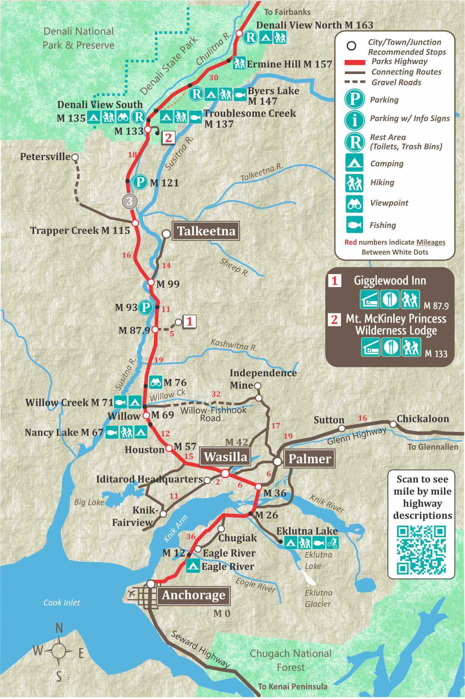
Iditarod Headquarters
Wasilla is home to the Iditarod Headquarters, which features a museum, gift shop, sled dog rides. Turn left on the Knik Goose Bay Road (when heading North) and drive 2 miles.
Mile 47

Big Lake Recreation Area
At Mile 52.2 is the road to Big Lake Recreation area, one of the major recreational areas for Southcentral Alaska. There are numerous lakes and campgrounds in this area including Big Lake, Beaver Lake, Rocky Lake and Horseshoe Lake. The lakes are connected by dredged waterways. Fishing is good for rainbow, lake trout, Dolly Varden, burbot, and landlocked salmon.
Hatcher Pass
Hatcher Pass can be accessed from Palmer, Wasilla or Willow. The Willow-Fishhook Road from mile 71 leads to Hatcher Pass. most of this road is gravel and rough and may not be suitable for larger RV’s. Hatcher Pass is closed during the winter. If you decide to visit Hatcher Pass, be sure to stop at the Independence Mine State Historical Park.
Talkeetna, Alaska
Talkeetna can be reached on a 14 mile side road at mile 99 of the Parks Highway. Talkeetna is a cute frontier town that is the staging area for mountaineers attempting to climb Mt. Denali. It is also where most of the Denali Flightseeing tours depart from.


Denali State Park
Denali State Park begins at mile 132 of the Parks Highway and ends at mile 168. The Denali State Park has some of the best, and most accessible viewpoints of Mt. Denali.
The western boundary of Denali State Park touches the south eastern boundary of Denali National Park.
Mile 133

Denali Viewpoint (South)
At mile 134.7 there is a large rest area with magnificent views of Mt. Denali. There is plenty of space for all size RV’s. There is informational signs on the mountain and plenty of amazing scenery to enjoy.
K’esugi Ken Campground
Located at Mile 135.4 of the Parks Highway, this state campground offers 32 RV sites with electric hookups, 10 walk-in tent sites, three public-use cabins, and a group camping area. Views of the Alaska Range and Denali are available from several sites. An interpretive center, over 2 miles of trails, and ADA-compliant facilities round out the amenities.
Byers Lake Campground
Byers Lake Campground at mile 147 is in Denali State Park and has awesome views of Mt. Denali. There are 73 sites and the campground has water, toilets, a boat launch, fishing and hiking trails.
Denali Highway
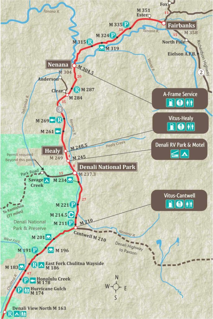
The Denali Highway meets the Parks Highway at Cantwell, at mile 210. The Denali Highway connects to Paxson on the Richardson Highway. The highway is mostly gravel and not recommended for large RV’s. However, it is a very beautiful and rugged highway, and should be added to any Alaskan adventure looking to get away from the crowds.
Most car rental companies do not allow you to drive the Denali Highway, but there are a few that do. You can find more info here.
Denali National Park
Denali National Park is the crown jewel of Interior Alaska. This is where you will find Mt. Denali, the tallest peak in North America. The entrance to the park is at mile 237.3,
You won’t be able to see Mt. Denali from the Denali town (which is 1 mile past the Denali Park Entrance), but if you take a shuttle into the park, you will get spectacular, close-up views of this towing mountain. Only the first 15 miles of the Park Road are open to the public. To go further on the Park Road, you will need to take a shuttle or have a park pass, which are given out in a lottery each year.
If you have reservations at one of the campgrounds inside Denali National Park, you will also be allowed to drive further than Savage River at mile 15.
Hotels & Camping in Denali


Things To Do in Denali


Healy
Healy is 9 miles from the Denali National Park Entrance. Many people choose to base themselves in Healy because it is less busy and less expensive than staying in the heart of Denali. There are hotels and campgrounds and a grocery store in Healy.


Nenana
The village of Nenana is situated at the confluence of the Nenana and Tanana Rivers about halfway between Fairbanks and Denali National Park.
Nenana is famous for its Ice Classic, a lottery based on guessing when the ice in the Tanana River will break up in April or May of each year; a tradition since 1917.
Nenana Visitor Information Center & Three Rivers Trading Post is located in the cabin at the corner of the Parks Highway and the entrance to Nenana.
Nenana offers visitors a truly authentic Alaskan town with a surprising number of amenities including museums, shopping and restaurants.


Ester
The community of Ester is located about 8 miles west of Fairbanks and is one of the oldest gold mining settlements in Alaska’s Interior. Gold was discovered on Ester Creek in 1906, and the camp that developed quickly grew into one of the most productive mining districts in the Interior. Ester remains a small but memorable stop where Alaska’s gold mining past is still visible in everyday life.


Fairbanks
Fairbanks is Alaska’s second largest city and the hub for Alaska’s Interior and Arctic. It’s summers are known for the midnight sun, which never seems to set and its winters are known for it’s brilliant Northern Lights.
Accommodations & Camping in Fairbanks


Things to Do in Fairbanks