Top of the World Highway

The Top of the World Highway is really two highways. In the Yukon the Top of the World Highway is Yukon Highway #9. The Top of the World Highway in Alaska is the Taylor Highway. The Taylor Highway runs from the Alaska Highway all the way to Eagle, Alaska.

The length of the Top of the World Highway is 175 miles/281 km and connects Dawson City in the Yukon to the Alaska Highway at the Tetlin Junction.

The Top of the World Highway is only open from June to September. In 2024 the border is scheduled to be open from June 1 to Sept 4.

Many travelers use the Top of the World Highway when driving between Fairbanks, Alaska and Dawson City, Yukon, which is 398 miles/640 km. The distance from Tok Alaska to Dawson City is 187 miles and the distance from Dawson City to Chicken, Alaska is 106 miles/171 km.

Top of the World Highway Map.

Yukon Territory Map

When entering or leaving Dawson City on the Top of the World Highway, you will need to take the George Black Ferry. It crosses the Yukon River, for free, 24 hours a day in the summer.

The first 106 km to the border is mostly on a chip-sealed surface with gravel sections. There are a number of scenic overlooks on this part of the highway.

For a complete list of Things to do in the Yukon and Alaska on your trip north, visit our Things To Do section.

The Canada/U.S. border

The border is open from early June to early Sept. from 8am to 8pm Alaska time and 9am to 9pm Yukon time. Everyone crossing the border will need proper ID, such as a passport.

The Poker Creek/Little Gold Creek Border Crossing is North America’s most northern international border crossing. The border does not always have the same opening and closing dates as the Highway, so check ahead if you are traveling early or late in the season. In 2024, the border is scheduled to open June 1 and close September 4.

Boundary Spur Road from the U.S./Canada Border to Jack Wade Jct. is paved. At the junction you join the Taylor Highway, which travels west to Chicken, Alaska or north to Eagle, Alaska. The 30 miles from Jack Wade Junction to Chicken is gravel and can be challenging to drive. Give yourself plenty of time to reach your destination.

At mile 66 of the Taylor Highway you will find the community of Chicken, home of the Pedro Gold Dredge and Tisha’s Schoolhouse. Chicken is a good place to stay over as there is lots to see and do in this historic community. The road between Chicken and Tetlin Junction has been reconstructed and is usually in good condition.

The Top of the World Highway is a scenic route with breathtaking views that should be enjoyed with plenty of stops along the way.

For a complete list of Things to do in the Yukon and Alaska, visit our Things To Do section. For information on RV and tent camping, visit our section on camping in Alaska. To determine when you should plan your trip to the Yukon and Alaska, visit our page on the best time to visit Alaska.

Top of the World Highway Highlights

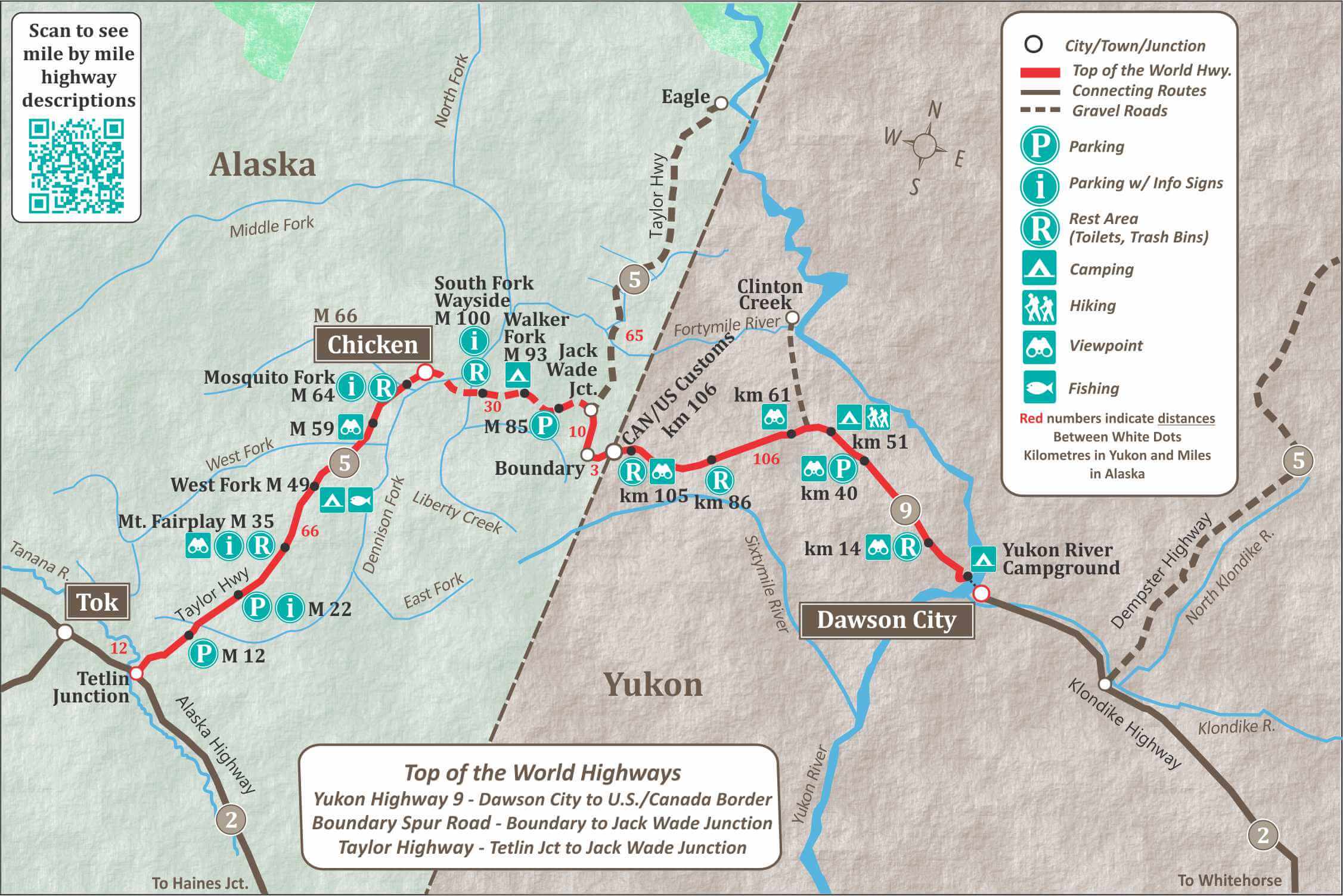
Dawson City is at the beginning or end of the Highway, depending on the direction you are travelling. This historic city has a lot to offer visitors.

Km 0.3
Yukon River Campground, 94 camp sites, water (boil), pit toilets, firewood, shelters. Fee area.

Km 4
Top of the World Golf Course. 9 holes, rentals, pro shop. 867-993-5888

Km 5
Great views of Dawson City, Klondike and Yukon Rivers. No parking available.

Km 14
Rest area, tables and toilets. Information sign on Top of the World Highway.

km 61.5
Scenic Viewpoint

km 97.9
Scenic Viewpoint

Km 100.8
Rest area with view and toilets. Information sign on Top of the World Highway.

Km 106.2/Mile mile 65.8
Canadian and U.S. Customs offices. Open 9am to 9pm (Pacific Time) when Dawson City Ferry is in operation. Road is closed in winter.

Mile 96 (Taylor Highway Mile Marker) – Jack Wade Junction
The Taylor Highway continues 65 miles/104 km north to Eagle, Alaska. Turn west for to head towards Chicken and the Alaska Highway.

Mile 66.4
Community of Chicken has RV parks, cabin rentals, 2 cafes, gift stores a post office and airport. Historical Community of Chicken, dates back to 1890’s and is on the “National Register of Historical Places.” 

Chicken Gold Camp

Mile 49
West Fork campground, 25 campsites, tables and pit toilets. Handicap accessible. Fee area.

Mile 35
Mt. Fairplay Wayside. Rest area with Interpretive sign on Taylor Highway, viewing platform, toilets.

Mile 22
Parking with infomation signs on the Forty Mile Region.

Mile 0
Tetlin Junction, on the Alaska Highway. Mile 1301.7 on Alaska Highway. Turn right to reach the village of Tok, 13 miles west on the Alaska Highway.

Top of the World Highway in Yukon
Views along the Top of the World Highway
Dawson City Golf Course
Top of the World Golf Course in Dawson City

Top of the World Highway Map

This map of the Top of The World Highway Shows how it crosses between the Yukon and Alaska. The Highway is made up of Yukon Highway #9 and the Taylor Highway in Alaska.

map of the top of the world highway
Map of the Top of the World Highway

Top of the World Highway FAQS

Is the Top of the World Highway Paved?

The Top of the World Highway has both paved and unpaved sections. From Dawson City to the Alaska Border starts with a 9 km section that is paved, but after that, the majority of the highway is gravel. There are a few paved sections remaining but don’t expect long smooth, paved road.

The road is narrow, without much shoulder, and plenty of potholes and surface breaks, making for slow driving.

13 miles after the Alaska Border is paved but the Taylor Highway section from Jake Wade Junction to Chicken is not paved and can be rough. 

From Chicken to the Alaska Highway, the road is in good condition and is mostly paved.

How High is the Top of the World Highway?

The Latitude of the most northern point of the Highway is 64.233. This is just a couple of degrees south of the Arctic Circle, which is at latitude 66.30. 

There are only two highways in North America that go further north. The Dempster Highway in the Yukon and The Dalton Highway in Alaska.

The highest summit of the Top of the World Highway is at 4,515 ft/1,376 meters. The summit is at Km 104, near the Alaska/Yukon border.

Is the Top of the World Highway Open?

The Top of the World Highway Border crossing is open in 2023 from June 1 to September 5.

US Customs – Call for updates:  (703) 921-7750

Canada Customs will be open June 1 to Sept 5.

Once the Border closes it is no longer possible to drive the entire length of the Top of the World Highway. However, it is still possible to drive the US side or the Canadian side until the snow arrives.

Alaska Travel Tips

Sign up for our 4-part email series to discover critical information for planning your ultimate Alaska vacation!

Alaska Bear

HEY!

Looking to see bears in Alaska?

Check out these Amazing Alaska Tours.

Think You Know Alaska?

Take the quiz and find out...