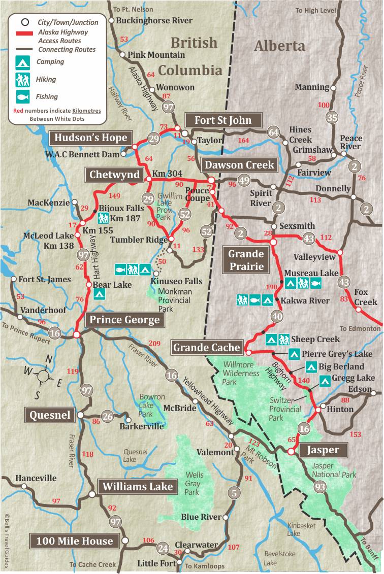
The John Hart Highway, connects 406 km/mile 252 miles from Prince George to Dawson Creek and the start of the Alaska Highway begins. There is great fishing in the many lakes and streams along the way. Summit Lake is situated on the Arctic-Pacific divide and here you will find excellent char and rainbow trout fishing.
Mackenzie is reached by a 29 km/18 mile side road that starts at km 155. It has a population of approximately 4,539 and offer a variety of visitor facilities. Mackenzie was built in 1965 to service the construction workers of the Peace River Dam Project. The first residents arrived in July 1966 and Mackenzie has never looked back. Visitor Information is at the junction of Highway 97 (Hart Hwy) and Highway 39 (hwy to Mackenzie).
Chetwynd is the largest town on the Hart Highway between Prince George and Dawson Creek. it is 304 km/189 miles from Prince George to Chetwynd and 90 km/56 miles from Chetwynd to Dawson Creek.
Plan your own custom Itinerary for the Hart Highway, try our Free Travel Planner. Select “Routes TO Alaska” and then select the “Alaska Highway Access from British Columbia“
Hart Highway to Tumbler Ridge
From the Hart Highway you can access the town of Tumbler Ridge by heading south on Highway 29, which intersects with the Hart Highway near Chetwynd.
Built as an “instant town” in 1981, Tumbler Ridge was carved out of the wilderness to facilitate coal mining activity in the area. Fascinating geology, an abundance of waterfalls and an amazing discovery of dinosaur trackways all played a part in Tumbler Ridge being designated a UNESCO Global Geopark in 2014.
One of the Tumbler Ridge area’s most famous attractions is Kinuseo Falls in Monkman Provincial Park. The falls are spectacular, and at 70 metres/230 ft. they are taller than Niagara Falls. They are located 60 km south of Tumbler Ridge, 48 km of which is on a gravel forest service road. Monkman Provincial Park has 20 dry campsites and a day-use area, just 3 km from Kinuseo Falls.
To continue to Dawson Creek from Tumbler Ridge drive 96 km on Highway 52 North. At the Hart Highway, turn right (east) and drive 13 km to reach Dawson Creek.
Hart Highway to Hudson’s Hope
From the Hart Highway you can reach Hudson’s Hope by heading north on Highway 29 from Chetwynd. Highway 29 stretches 137 km, passing through Hudson’s Hope and connecting with the Alaska Hwy, north of Ft. St. John.
Moberly Provincial Park is 25 km northwest of Chetwynd, has 109 campsites, a picnic area, boat launch and sani-dump. There is a 3.5 km access road to reach the park on the shores of beautiful Moberly Lake.
The Hudson’s Hope area saw explorers as far back as the late 18th century, but the modern town really developed in the 1960’s during construction of the Peace River Dam, now known as the W.A.C. Bennett Dam. The Dam, only 24 km west of town, is one of the world’s largest “earth filled” Dams, rising 183 metres/600 ft. The Visitor Centre at the Dam is open from late May to early September and offers tours.
From Hudson’s Hope to the Alaska Highway is 73 km and passes Site C, the new mega Dam being built. There are a number of steep climbs and descents along this section, including some 10% grades.
Hart Highway Map
Tourism Prince George Visitor Info Centre
The Centre is a welcoming place, providing free wireless Internet access, a guest lounge area, restroom facilities, bicycles and fishing rods to borrow at no charge, a gift shop and displays from various local artists. Staff will be delighted to help you find anything you need to know about Prince George. located at 101-1300 First Avenue, near downtown along Highway 16. Tourismpg.com
0
Junction of Highways 16 and 97. Highway 16 leads west to Prince Rupert BC.
4
John Hart bridge over the Nechako River.
7
Northwood Pulp Mill Road.
19
Hart Highway RV park.
28
Parking by Salmon River.
39.8
Parking on both sides of highway.
41.5
Giscome portage, heritage attraction.
47.5
Rest area.
49.5
Summit Lake has a boat launch and picnic area. Summit Lake is a wonderful place to drop a line and go fishing, so be sure to bring the right fishing gear with you.
53.5
North access to Summit Lake.
63.1
Parking beside Cottonwood Creek.
75.3
Crooked River Provincial Park. 90 camp sites, picnic sites, dump station, swimming, fishing (no motor boats allowed).
76.1
Bear Lake, services.
93
Red Rocky Lake.
113.2
Rest area by Crooked River.
128.8
Whiskers Point Provincial Park, camping, boat launch, picnic area, dump station, toilets, beach.
137.6
McLeod Lake, services.
138.6
Side road to Carp Lake Provincial Park 30 km/18 miles.
139.5
Parking.
146.4
Tudyah Lake Provincial Park, camping, boat launch, picnic area, swimming, and fishing.
154.4
Parsnip River.
155.2
Mackenzie Junction. 29 km/18 mile side road to Mackenzie, population 4,539. Visitor facilities.
Mackenzie was built in 1965 to service the construction workers of the Peace River Dam Project. The first residents moved in July 1966 and Mackenzie has never looked back. Lumbering is the major industry. Mackenzie is located at the south end of Williston Lake.
161.1
Parking.
172.8
Parking.
176.8
Honeymoon Creek. Highway Maintenance Camp.
183
Rolston Creek, parking.
187.7
Bijou Falls Provincial Park, day-use area – nice picnic spot, tables, toilets.
192.4
Pine Pass Summit 874 m/2867 feet.
194.9
Powder King ski resort.
212
Parking.
223
Parking.
226.5
Link Creek.
227
Parking.
229
West Pine River bridge.
230
West Pine River bridge.
230.3
Rest area beside Pine River, toilets.
236
Side road to Pine River.
244.2
Big Boulder Creek.
253.6
Fisher Creek.
259.5
Crassier Creek.
265.6
Pine Valley rest area.
275.2
Peace Foothills rest area.
288
Parking.
298
Wildmare Grove Campsite.
304
Chetwynd, population 3,100 was formerly known as “Little Prairie” but was renamed to honor the late Ralph Chetwynd, a British Columbia Minister of Railways, who fought hard to have the provincial railroad extended to this region. Chetwynd’s main industries are forestry, mining, natural gas processing, farming, and ranching. The town has a full range of visitor facilities.
The Chetwynd Visitor Centre
Excellent information on the Peace River region.open daily in the summer months, located on Highway 97. www.gochetwynd.com
306
The kilometre posts in place from Chetwynd north indicate kilometres from Chetwynd toDawson Creek BC.
308.3
Junction. Side road leads to W.A.C. Bennett Dam and Hudson Hope 65km/40 miles and rejoins the Alaska Highway 86 km/53 miles north of Dawson Creek.
Hudson’s Hope is a unique northern community. Surrounded by lakes and rivers, it offers a wide range of outdoor recreational activities including excellent fishing, canoeing, camping and hiking.
The Hudson’s Hope Visitor Centre
Excellent information on the community and the nearby W.A.C. Bennett Dam. www.hudsonshope.ca
309.4
Junction with Heritage Highway. Side road to Tumbler Ridge 91 km/56 miles.
Tumbler Ridge is a picturesque community is situated at the heart of the Tumbler Ridge UNESCO Global Geopark. In addition to walking in the footsteps of dinosaurs, visitors can also take in breathtaking alpine vistas, sparkling waterfalls and a myriad of outdoor activities.
The Tumbler Ridge Visitor Centre
Find information on nearby parks, hiking trails and where to explore for Dinosaur tracks. www.tumblerridge.ca
324
Parking on both sides of highway.
334.4
Parking.
338.4
East Pine Provincial Park, picnic area and boat launch.
344
Parking.
360.9
Parking.
386.7
Junction with Highway 52 to Tumbler Ridge 96 km/60 miles. From Tumbler Ridge Highway 52 continues 144 km/90 miles to Highway 2, south of Dawson Creek.
387.2
Kiskatinaw River.
394
Junction with the Alaska Highway.