The Campbell Highway is a captivating route stretching across the Yukon, Canada, that offers travelers a unique path through some of the most pristine and less-traveled landscapes in the Yukon. Connecting Watson Lake in the southeast to Carmacks in the west, this 362-mile (583 km) is an ideal route for those seeking to escape, and immerse themselves in the unspoiled wilderness of the Yukon.
Campbell Highway History
The Campbell Highway was originally constructed to facilitate access to the mineral-rich regions of the Yukon Territory. Named after Robert Campbell, a notable fur trader and explorer for the Hudson’s Bay Company, the highway traces a path through some of the most rugged terrain in Canada. Campbell’s explorations in the early 19th century opened trading posts along this route, and paved the way for the development of this remote region.
The Campbell Highway’s construction began in the mid-20th century, primarily to support mining operations and provide a reliable route for transporting natural resources mined from the region. By the late 1960s, the highway was officially opened to the public.
Campbell Highway Route Overview
Watson Lake
The Campbell Highway begins in Watson Lake, a key community in southeastern Yukon. Known for its Signpost Forest, a quirky attraction featuring thousands of signposts from around the world, and the spectacular Northern Lights Centre, Watson Lake serves as the gateway to the Yukon’s adventure routes.
Faro
The Community of Faro is a former mining town that once had 2,500 people living and working here. Now only about 400 locals remain. The zinc/lead/silver mine closed in the late 1990’s but the local residents love the quiet, remote lifestyle in Faro.
Where to Stay in Faro
John Connolly RV Park & Campground: A well-spaced, tree-shaded RV and tent campground right in town, with showers, laundry, and free firewood. It also doubles as the trailhead for the Van Gorder Falls hike, making it a convenient base for exploring Faro on foot.
Far-O-Way Guest House: A renovated 11-bedroom guest house across three units, popular with both travellers and work crews needing extended-stay housing. Full kitchens, laundry, WiFi, BBQ decks, and a hot breakfast spread are included.
Faro Vacation Rentals: Three fully furnished 3-bedroom townhomes with full kitchens and laundry — a good self-contained alternative to a hotel for weekend visits or longer work stays.
Fuel note: Faro’s gas station is credit card only — no cash or debit accepted.
Things to See and Do in Faro
Campbell Region Interpretive Centre: Housed in a beautiful log building, the CRIC offers permanent displays on the region’s history, geology, and wildlife, along with trip-planning info for area hikes and free wifi. It’s the best first stop in town before heading out to any of Faro’s trails.
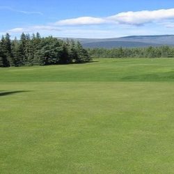
Faro Golf Course: Faro’s unique nine-hole golf course winds right through the middle of town, offering stunning mountain views between holes. The course hosts an annual tournament each July — a fun stop for golfers passing through on the Campbell Highway.
Van Gorder Falls: A short 3 km trail — starting right from the John Connolly RV Park & Campground — leads hikers to a viewing platform overlooking Van Gorder Falls, a scenic waterfall tucked into the Yukon wilderness.
Faro Recreation Centre: Impressively equipped for a town this size, the Rec Centre features a full gym, sports hall, arena, squash court, and a summer pool, plus a lounge with foosball and air hockey. A great option for families or anyone looking to stretch their legs after a long drive.
Faro Arboretum: Just off Mitchell Road, the Arboretum is a peaceful day-use park set along Van Gorder Creek, with a 1.2 km interpretive loop trail, picnic tables, and a gazebo — a lovely spot for a quiet nature break.
Anvil Range Arts Society: Faro’s local arts community is kept alive by ARAS, which supports area artists and hosts pop-up exhibits and workshops throughout town while fundraising for a permanent gallery space.
The Tintina Trench: Faro sits along the Tintina Trench, a dramatic geological fault valley stretching nearly 1,000 km from British Columbia into Alaska. The trench acts as a natural funnel for migrating birds, making the Faro area one of the best birdwatching spots in the Yukon, and its sweeping landscape views are shaped by millions of years of geological activity.
Lapie Canyon: Along the Campbell Highway between Faro and Ross River, Lapie Canyon offers dramatic canyon views and a hiking trail along the Lapie River, with a nearby campground for those who want to stay overnight.
Pelly River: The Pelly River offers a popular put-in point near Faro for canoeists and kayakers looking to paddle this classic Yukon river.
Faro Mine: Once the largest open-pit lead-zinc mine of its kind in the world, the former Faro Mine is now the site of an ongoing, large-scale environmental reclamation project. Visitors can drive out to see the scale of the operation and learn about the remediation work underway.
Ross River
The village of Ross River is located at the confluence of the Ross and Pelly Rivers. It’s a small but historically significant community, deeply rooted in the Yukon’s Indigenous heritage and mining history.
The area around Ross River is ideal for hiking, fishing, and camping. Visit interpretations of old mining sites and learn about the various mining operations that were once pivotal to the area’s economy.
The Ross River Suspension Bridge is one of the longest suspension bridges in North America, offering a unique opportunity for a walk across the Pelly River and providing spectacular views of the surrounding area. It is 316 meters/1036 feet long and was built in 1943 as part of the Canol oil pipeline system. The South Canol Road connects Ross River and Johnson’s Crossing on the Alaska Highway route.
Due to its remote location and minimal light pollution, Ross River is an excellent spot for witnessing the Northern Lights during the winter months.
For a place to stay, Raven Nest Lodge offers guest rooms sleeping up to 8, run by Kaska artist Dennis Shorty, with airport pickups, canoe rentals, and kick-sled rentals available for guests interested in a cultural stay.
The Ross River Recreation Centre is the community’s hub, with a natural-ice hockey rink in winter and a small kitchen and meeting space — also home to the Ross River Youth Centre.
Fuel note: Ross River’s gas station, Tu-Lidlini Petroleum, is credit card only — no cash or debit accepted.
Carmacks
The highway culminates in Carmacks, nestled along the Yukon River. Named after George Carmack, a pivotal figure in the Klondike Gold Rush, this town is steeped in history. The Klondike Highway passes through Carmacks, on its way to Dawson City and the Dempster Highway.
Notable Waysides & Viewpoints
Nahanni Range Road Junction (Km 108): Marks the turnoff onto Yukon Highway 10, a summer-only road running 125 miles to the former Canada Tungsten Mine. The turnout has an outhouse, litter bin, and Roads to Resources sign, but there are no services along Nahanni Range Road and the Yukon government does not recommend it for tourist travel.
Finlayson Lake Viewpoint (Km 233): A turnout overlooking Finlayson Lake, which sits directly on the Continental Divide, with a picnic area, observation platform, and information panels on the Finlayson caribou herd.
Eagle’s Nest Bluff / Columbian Disaster Site (Km 555): A turnout with litter bins and outhouses marking the 1906 sinking of the sternwheeler Columbian at Eagle Rock — the worst riverboat disaster in Yukon River history. Eagle’s Nest Bluff to the south overlooks the Yukon River.
Total Distance and Approximate Travel Time
The entire Campbell Highway stretches over 362 miles (583 kilometers). The journey typically takes around 8 to 10 hours of driving time, depending on road conditions and the traveler’s pace. Road conditions can vary, with both gravel and paved sections of the highway. Travelers should take their time and plan at least 2 days to complete the highway. The relatively long drive through this wilderness provides ample opportunities for wildlife sightings, including black bears, Moose and more.
This rugged and captivating route exemplifies the spirit of a true wilderness drive, offering an unparalleled journey through the unspoiled Campbell region.
Road Conditions and Maintenance
The Campbell Highway consists of both paved and gravel sections. Recent efforts have been made to maintain and improve the highway, ensuring it remains navigable for most vehicle types. However, travelers should be prepared for stretches of gravel roads, especially in the more remote areas of the unspoiled Campbell Region. Regular maintenance is conducted, but conditions can vary due to weather and seasonal factors. It’s always a good idea to check the latest road conditions before embarking on your journey by consulting local resources or travel advisories.
Tips for Driving Safely on the Campbell Highway
Vehicle Preparation: Ensure your vehicle is in good condition, with a full tank of fuel, spare tires, and a well-stocked emergency kit.
Drive Cautiously: Keep your speed moderate, especially on gravel sections, and be vigilant for wildlife such as black bears that may cross the road unexpectedly.
Stay Connected: Cell service can be sparse along the route, so let friends and family know your route ahead of time.
Plan Fuel Stops: Fuel stations are limited to Watson Lake, Ross River, Faro and Carmacks, so plan accordingly..
Seasonal Variations and What to Expect
Spring and Summer: The warmer months offer the best driving conditions, with most of the road being accessible and maintained. Expect some construction activity as this is the optimal time for road work.
Autumn: Fall provides stunning foliage but can also bring unexpected weather changes. Reduced daylight hours mean planning your driving schedule becomes crucial.
Winter: Winter travel is challenging due to snow and ice. Many sections may be impassable, and facilities can close for the season. Only experienced winter drivers with fully winterized vehicles should attempt this journey.
Being well-prepared for your adventure on the Campbell Highway will ensure a safer and more enjoyable experience on this wilderness drive through the Yukon.
Connecting Routes
Nahanni Range Road
The Nahanni Range Road (Yukon Highway 10) branches off from the Campbell Highway and leads to the Selwyn Mountains, providing access to several mining operations. This remote road leads towards the Nahanni Range, a mountainous region known for its unique geological features and stunning landscapes.
Keep an eye out for wildlife such as moose, caribou, and black bears as you journey through this remote region. Frances Lake is a large lake that provides opportunities for fishing, kayaking, and camping. Its serene environment makes it perfect for outdoor enthusiasts seeking a tranquil escape.
North Klondike Highway
Overview and How it Connects to Campbell Highway
The Klondike Highway (Yukon Highway 2) is a vital route through the Yukon that runs from the southern terminus in Skagway, to its northern terminus in Dawson City. This route traces the path of the original Klondike Gold Rush trail and follows the Yukon River for much of its length. The highway is predominantly paved and well-maintained.
Carmacks is at km 356 of the Klondike HIghway, 152 km north of Whitehorse. The Campbell Highway Junction is just north of Carmacks at km 359. Turn East to head towards Faro, Ross River and Watson Lake.
The Klondike Highway is dotted with campgrounds, picnic areas, and trailheads, making it ideal for hiking, fishing, and camping. The Klondike Highway also has more regular services compared to the remote Campbell Highway. The Klondike Highway Connects to the Alaska Highway near Whitehorse.
Common Wildlife Sightings Along Campbell Highway
The Campbell Highway, traversing through the heart of the Yukon’s wilderness, is a haven for wildlife enthusiasts. Common sightings include:
Black Bears: Often seen foraging along the roadside or roaming through the forests.
Moose: These large mammals are frequently spotted near wetlands and forested areas.
Caribou: Herds of caribou can be seen migrating across the landscape, particularly in the more remote sections of the route.
Wolves: Although more elusive, wolves occasionally make an appearance.
Birds: A variety of bird species, including raptors like bald eagles and smaller songbirds, can be observed throughout the year.
Campgrounds Along the Campbell Highway
Camping along the Campbell Highway provides a wonderful opportunity to fully immerse yourself in the natural beauty of the Yukon. Here are some notable campgrounds:
Simpson Lake Campground (Km 81): 10 sites with a boat launch and dock, cook shelter, and playground. A popular base for anglers and fall hunters. Gate open year-round.
Frances Lake Campground (Km 171): 24 sites with a boat launch and sandy/cobble beach. Site of the Yukon’s first Hudson’s Bay Company trading post (1842-1851). Serviced late May to September.
Lapie River Canyon Campground (Km 364): 20 sites overlooking a small canyon on the Lapie River, near Ross River. Popular for kayaking, canoeing, and rafting, with nesting ravens and the rare Yukon goldenweed along the canyon walls.
Drury Creek Campground (Km 468): 10 sites on the east end of Little Salmon Lake (Chu Cho), popular with Faro residents. Boat launch and sandy beach.
Little Salmon Lake Campground (Km 501): 22 sites on the west end of the same lake, with a boat launch and sandy beach. Watch for wind and waves, and check seasonal fishing restrictions protecting Lake Trout.
Frenchman Lake Campground (Km 543, then 2.8 miles north on Frenchman Road): A small, cozy 11-site campground with a boat dock, good for boating and swimming.
Most campgrounds along the Campbell Highway offer basic amenities like picnic tables, fire pits, and pit toilets.
Motel and Hotel Options in Nearby Towns
While the Campbell Highway is known for its remote and wild nature, nearby towns provide more comfortable accommodation options:
Watson Lake: As the starting point of the Campbell Highway, Watson Lake offers a range of accommodation options including motels, lodges, and bed & breakfasts. Some notable mentions are:
Air Force Lodge: A unique and historic building with modern amenities.
Big Horn Hotel: Known for its comfortable rooms and convenient location.
Faro: Far-O-Way Guest House and Faro Vacation Rentals both offer comfortable, self-contained lodging in town, well suited to both travellers and extended work stays.
Carmacks: At the end of the Campbell Highway, Carmacks provides several options, including motels and lodges. Popular accommodations include:
Carmacks Hotel: Offers basic but comfortable rooms and is conveniently located.
River View Inn: Known for its scenic views and friendly service.
Emergency Contacts and Services Along the Route
Visitor Centers: Visitor information centers, operated by the Yukon Government are located in Watson Lake, Faro, and Carmacks and can provide assistance and updates on road conditions.
Roadside Assistance: Check with your insurance provider about coverage or additional roadside assistance services.
Health Services: Know the locations of the nearest health facilities in Watson Lake, Faro, and Carmacks in case of medical emergencies.
Health Centers:
– Watson Lake Community Hospital (Phone +1 867-536-4444)
– Faro Health Centre (Phone: +1 867-994-4444)
– Carmacks Health Centre (Phone: +1 867-863-4444)
RCMP Detachment: Available in Watson Lake (Phone: +1 867-536-2677).