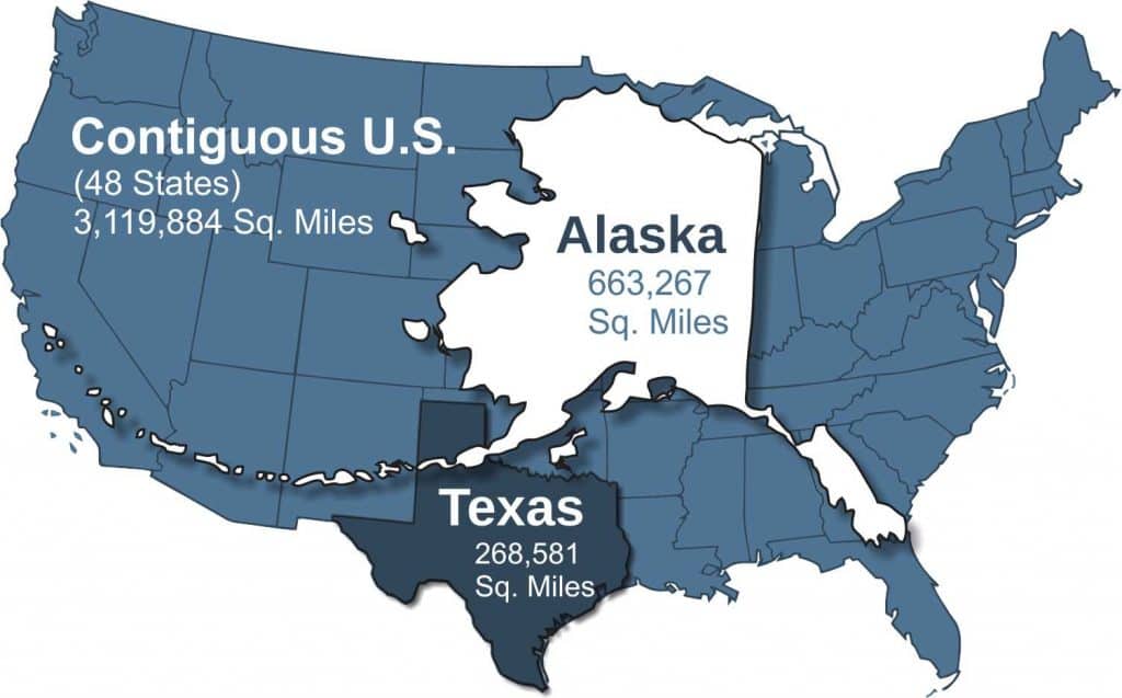
Alaska is by far the biggest state in the USA. It is 663,267 square miles of rich broad land that has produced billions of dollars of gold and oil as well as fish, furs, and timber. Alaska is unspoiled, uncrowded and is vibrant with promise. The things which draw visitors to the nation’s largest state are as diverse as the land itself. Blue-green glaciers, countless fish filled lakes and rivers, steaming volcanoes, tall mountains and broad valleys populated by moose, bear and other wildlife. But perhaps the thing that most attracts Alaska visitors is an opportunity to heed the “call of the wild” a chance to return to wilderness not found elsewhere.
Not only is Alaska the biggest state, covering the most land area, but it is also home to the highest point in North America. Mount Denali (Formerly Mt. McKinley) is in Denali National Park and is 20,310 ft tall. Denali is visible from many places along the Parks Highway as well as from the town of Talkeetna. It is one of the most visited attractions in all of Alaska.
So, is Alaska Bigger than Texas?
Yes, Alaska is bigger than Texas, which is the second largest state at 268,581 square miles. One of the favorite sayings of Alaskans is “If you cut Alaska in half, Texas would be the third largest state in the Union!” So, in the Alaska vs Texas battle for size supremacy, Alaska is the BIG winner!
How Big is Alaska Compared to the U.S.?
When Alaska is compared to the U.S., it is large enough to fit in as many as 19 other states including New York, Florida, Oklahoma, Indiana and Pennsylvania. Check out this map on Digg to see the full list. Alaska is by far the biggest state in the USA.
How long is Alaska’s coastline?
Alaska’s coastline is incredibly long. In fact, it is 50% of the entire United States coastline! Alaska has 6,640 miles of coastline and the entire U.S. has 12,383 miles.
Discover an Amazing Alaska Itinerary
From 4 nights to 14 nights you’ll find an Incredible Alaska Itinerary!
Alaska’s Six Regions
Alaska is comprised of six distinct regions within the state, each with differences in climate, geography and economy.
Southeast Alaska
Found at the same latitude as Scotland, Southeast Alaska is only 600 miles from Seattle. Its land area is approximately that of Maine and is made up of several large islands and literally thousands of smaller ones, as well as a thin strip of rugged mainland bordering Canada. Juneau, the capital of Alaska, is found in Southeast and has a population of approximately 30,000. This makes it the largest city in this region of Alaska.
Can I drive to Southeast Alaska?
Southeast Alaska is served by the ferries of the Alaska Marine Highway System, as there are only three roads that connect Southeast to the mainland. It is possible to drive to Skagway via the Klondike Highway and Haines via the Haines Highway. There is also the small town of Hyder, that can be driven to from British Columbia via the Cassiar Highway.
The mild climate of the region seldom sees temperatures below 10° F in winter and in the summer, temperatures in between 60° and 70° F are normal. There is a lot of rain in Southeast Alaska, however, some areas are wetter than others. Annual rainfall can range from 25 inches to 150+ inches in Ketchikan.
Glacier’s, marine wildlife and stunning scenery attract visitors to Southeast Alaska. Here are some of the main attractions.
South-Central Alaska
South-Central Alaska is a diverse region of Alaska known for king-sized vegetables, lush forests, soaring mountain peaks, and protected harbors. It is also known for its oil and gas exploration and its lush farmland. Because it is protected from the Arctic weather by the 450-mile Alaska mountain range the Matanuska Valley, less than an hour north of Anchorage, is world-famous for its farm production. Enormous vegetables like 80-pound cabbages, 6 pound potatoes and 1500 pound pumpkins are grown annually.
Two thirds of Alaska’s residents live in South-Central, which is home to Alaska’s largest city, Anchorage. Anchorage is Alaska’s social, financial, trade and distribution center and is home to one of America’s busiest airports due to it being a major hub for international cargo shipments.
The Kenai Peninsula is also part of the South-Central region of Alaska. The Kenai Peninsula is where Alaskan’s go to play. It is as famous for it’s salmon and halibut fishing as it is for it’s camping and hiking. It’s also home to Kenai Fjords National Park, which can be accessed in Seward, Alaska. Whittier Alaska, on the Kenai is where many cruise ships start and end their Alaska Cruises. It is the closes cruise port to Anchorage. Whittier, Alaska is a small town that is accessed by the longest combination train/car tunnel in North America (2.5 miles).
Valdez is also part of South-Central Alaska. It is a beautiful city which is know for it’s boat tours into the stunning Prince William Sound. Columbia Glacier and Mears Glacier are the two biggest attractions in The Sound. These huge tidewater glaciers often put on an incredible show of calving enormous icebergs off their face. Valdez is only 119 miles from Anchorage by air, but 305 miles by the road (Richardson Highway and Glenn Highway)
Finally, the Matanuska-Susitna Borough (known as the Mat-Su) is also part of the South-Central Region. The Mat-Su is just outside of Anchorage and the major towns are Wasilla, Palmer and Talkeetna.
Here are some of the main attractions in South-Central Alaska.
The Interior
Alaska’s Interior is a huge rolling plateau between the Alaska Range to the South and the Brooks Range to the north. It stretches from the Canadian border on the east almost to the Bering Sea to the west. The Yukon River and its tributaries wind thousands of miles through this region to the Bering Sea. Native villages dot the banks along its entire length. There are many species of game including moose, caribou, bears and thousands of migrating birds in this region. Summer temperatures reach highs of 95°, while winter temperatures can drop as low as -60°. Fairbanks, AK is the second-largest city in Alaska with an area population of almost 100,000 people (including the nearby military bases and surrounding Borough). It is also home to several of Alaska’s most popular attractions.
The Interior of Alaska also connects to The Yukon, famous for it’s vast wilderness and the 1898 Klondike Gold Rush to Dawson City. Dawson City Yukon can be reached via the Top of the World Highway in Alaska’s Interior.
Alaska's Arctic
Over 50 years ago, oil was discovered at Prudhoe Bay on the Arctic coastlines of the North Slope of the Brooks Range. This motivated a seven-company agreement to build a $7.7 billion dollar pipeline, 800 miles south to the ice-free port of Valdez. Construction of the pipeline was started in 1975 and completed in 1977.
The Arctic, north of the Brooks Range, is covered in rolling tundra that is barren and treeless. Its shores are met by the Arctic Ocean and is covered in ice seven to eight months of the year. The climate is extreme in comparison with the temperate climates of the continental United States. Summer temperatures averaged only 40° F while winter temperatures average -17° F. This is the land of the midnight sun and for two months in the summer the sun never drops below the horizon. While in winter, the sun never rises above the horizon for two months. This is the home of polar bears, walrus, grizzly bears, caribou, and wolves. Kotzebue and Barrow are the principal cities in the Arctic and air travel is the most common means of access to and from the Arctic. However, it is possible to drive the Dalton Highway. If you are looking for a tour to the Arctic, checkout Northern Alaska Tour Company. They are experts in show guests this region, whether for a day or a week.
Western Alaska
This is the remote area between the interior and the Bering Sea and between the Seward Peninsula on the north and the Alaska Peninsula on the South. Nome is the most famous town in the region. It has a current population of approximately 3600 which is about half the size it was during the gold rush at the turn-of-the-century. This is also where you find the mineral rich Seward Peninsula with deposits of gold, silver and copper that are still being developed. High winds and high humidity mark the winters in Western Alaska while cool rainy and foggy weather prevails in summer. Commercial fishing is especially important to the economy of Western Alaska. Dillingham is the main supply port for operations in Bristol Bay, site of the Principal Fishing Grounds.
Southwest Alaska
Here is a dramatic land of contrasts that includes the Aleutian Islands, the Alaska Peninsula, and the Kodiak Island group. From the forest and hillsides, statuesque mountains and the lakes of the Alaska Peninsula, Southwest Alaska extends 2000 miles westward through the barren volcanic Aleutian Islands chain. Nature was violent in her creation of this area and the largest volcanic range on the continent is located here. A major visitor attraction is the Valley of 10,000 smokes in the Katmai National Park. Within this region are the breeding grounds of the sea otter, and the fur seal, which were decimated in the early part of this century by fur traders. Populations of these species have rebounded due to careful State and Federal controls on hunting. Kodiak which was the first permanent Russian settlement in Alaska is the largest town in this region. Because of its many canneries and processors, the city is called the King crab capital of the world.
Looking for Things to do in Alaska? Visit our page.
If you are planning to RV or Camp in Alaska, visit our page on what you need to know about camping in Alaska.
Interested in knowing the best time to visit Alaska, click on the link to find out.
Want to learn more about the Northern Lights in Alaska, just follow the link.