


Why Drive the Top of the World Highway?
The Top of the World Highway is one of the most extraordinary road trips in North America. Stretching 175 miles (281 km) across the Yukon and Alaska, it offers something no other highway on the continent quite matches: mile after mile of driving along open mountain ridgelines, with the landscape unfolding in every direction as far as the eye can see. For much of the route, you are driving above the treeline, on top of the world — which is exactly where the name comes from.
The Top of the World Highway is really two highways. In the Yukon the Top of the World Highway is Yukon Highway #9. The Top of the World Highway in Alaska is the Taylor Highway. The Taylor Highway runs from the Alaska Highway all the way to Eagle, Alaska.
The length of the Top of the World Highway is 175 miles/281 km and connects Dawson City in the Yukon to the Alaska Highway at the Tetlin Junction (13 mile south of Tok).
The Top of the World Highway will be open from Friday, May 22, 2026. 9:00 am to 7:00 pm Yukon Time/8:00 am to 6:00 pm AK Time, seven days a week. The port is scheduled to remain open until Tuesday, September 15, 2026.
Many travelers use the Top of the World Highway when driving between Fairbanks, Alaska and Dawson City, Yukon, which is 398 miles/640 km. The distance from Tok Alaska to Dawson City is 188 miles and the distance from Dawson City to Chicken, Alaska is 106 miles/171 km.
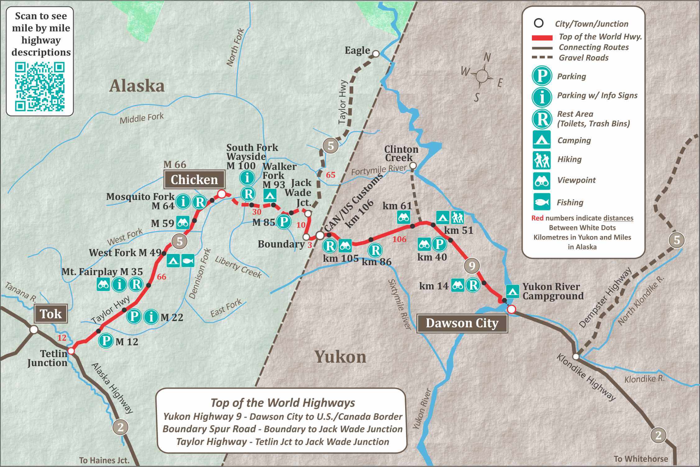
When entering or leaving Dawson City on the Top of the World Highway, you will need to take the George Black Ferry. It crosses the Yukon River, for free, 24 hours a day in the summer. The first 106 km to the border is mostly on a chip-sealed surface with gravel sections. There are a number of scenic overlooks on this part of the highway.
The 10 mile Boundary Spur Road from the U.S./Canada Border to Jack Wade Jct. is paved. At the junction you join the Taylor Highway, which travels west to Chicken, Alaska or north to Eagle, Alaska. The 30 miles from Jack Wade Junction to Chicken is gravel and can be bumpy and challenging to drive. Give yourself plenty of time to reach your destination.
At mile 66 of the Taylor Highway you will find the community of Chicken, home of the Pedro Gold Dredge and Tisha’s Schoolhouse. Chicken is a good place to stay over as there is lots to see and do in this historic community. The road between Chicken and Tetlin Junction has been reconstructed and is usually in good condition, with the occasional rough patch.
The Top of the World Highway is a scenic route with breathtaking views that should be enjoyed with plenty of stops along the way.
If you want to plan your own custom Itinerary for the Top of the World Highway, try our Free Travel Planner for Alaska and The Yukon.
The Canada/U.S. border Crossing Guide
The border is typically open from late May to early September, however the exact dates vary each year. Once opened, the Border is open from 8am to 6pm Alaska time and 9am to 7pm Yukon time. Everyone crossing the border will need proper ID, such as a passport. Click here for more border crossing details.
The Poker Creek/Little Gold Creek Border Crossing is North America’s most northern international border crossing. The border does not always have the same opening and closing dates as the Highway, so check ahead if you are traveling early or late in the season. In 2026, the border is scheduled to open May 22, 2026. 9:00 am to 7:00 pm Pacific Daylight Time, seven days a week. The port is scheduled to remain open until Tuesday, September 15, 2026.


What Makes This Highway Unique
Here are the reasons travelers put the Top of the World Highway on their bucket list:
- Ridge-top driving unlike anything else. Most of the Yukon section runs along the crests of mountain ridges, not through valleys. You are above the treeline for long stretches, with open sky in every direction.
- Panoramic views that never stop. From the high points along the highway, you can see hundreds of kilometers of untouched Yukon and Alaskan wilderness. On a clear day, the vistas rival anything you’ll find in the Rockies or the Alaska Range.
- Access to Dawson City, one of Canada’s most historic towns. The highway begins with a free ferry ride across the Yukon River after visiting Dawson City, the heart of the Klondike Gold Rush.
- Gold Rush history at every turn. The Fortymile Mining District, Chicken, Jack Wade Junction, and the surrounding region were central to the late 1800’s and early 1900’s Gold Rush.
- Chicken, Alaska — one of the most charming stops in interior Alaska. With a population of fewer than 20 year-round residents, Chicken is a quirky, welcoming community with a historic dredge, a famous schoolhouse, and a real frontier spirit.
- One of the highest-elevation international highways in the Yukon–Alaska region. The highway climbs to elevations that keep it snow-free only during the summer months, making it a truely seasonal alpine drive.
- North America’s northernmost international land border crossing. The Poker Creek/Little Gold Creek crossing is a uniquely remote border experience.
- Wildlife viewing in the Fortymile region. Moose, caribou, bears, foxes, and golden eagles are all common sightings along this route, particularly in the early morning and evening hours.
- Solitude and genuine wilderness. Traffic is light. Services are sparse. Cell coverage is almost non-existent. This is the real Alaska and Yukon.
Who Should Drive This Highway?
The Top of the World Highway is an excellent choice for travelers who:
- Are already visiting Dawson City and want to extend their trip into Alaska
- Are driving between Fairbanks and Dawson City and want the most scenic and shortest possible route
- Are doing a loop through Alaska and the Yukon and want to avoid retracing the Alaska Highway
- Are interested in Gold Rush history and want to see the landscape where it happened
- Want a genuine backcountry driving experience without the extreme remoteness of the Dalton Highway
What to Know Before You Go
The highway is seasonal. The border crossing is only open from late May to mid-September, and the George Black Ferry in Dawson City is required to access the Yukon section. The road surface is a mix of chip-seal and gravel. RVs and passenger vehicles can make the trip, but give yourself plenty of time and check road conditions before departing.
Fuel is available in Dawson City, Chicken, and Tok. There are no services on the highway itself
Top 13 Scenic Stops on the Top of the World Highway
The Top of the World Highway rewards travelers who slow down. Whether you’re looking for the best viewpoints, the most photogenic stops, or the key historic sites along the route, here is your guide to the 13 best stops from Dawson City to the Alaska Highway.
Midnight Dome Viewpoint
Side trip from Dawson City • Time needed: 30-60 minutes
Before the highway proper begins, Midnight Dome is worth the short detour. A paved road climbs to 884 meters above Dawson City, delivering one of the most celebrated views in the Yukon: the Klondike and Yukon Rivers converging far below, the broad valley stretching to the south, and at midsummer, the midnight sun hanging above the horizon. .
Photo tip: The classic shot looks southeast toward the river confluence. At the summer solstice, the sun stays visible all night — come back after dinner for extraordinary light.
Parking/Access: Suitable for most passenger vehicles and smaller RVs.
Dawson City Ridgeline Viewpoint
Approximately 5 km from the ferry landing, Yukon Highway 9 • Time needed: 10–15 minutes
Within the first few kilometers of leaving the George Black Ferry, the highway climbs steeply onto the ridge and delivers the first truly jaw-dropping panorama of the trip. Looking back toward Dawson City, you can see the Yukon River snaking through the valley far below. This is the moment travelers realize this highway is something special — and it only gets better from here.
Photo tip: Pull over completely before reaching for your camera. The roadside is narrow and the grade is steep. This is one of the most photographed views on the entire highway.
Parking/Access: Informal gravel pullout on the right side of the road heading west. Limited space — use caution.
Sixtymile Area Ridge Views
Yukon Highway 9, approximately 60–70 km from Dawson City • Time needed: 15–30 minutes
The Sixtymile River drainage area offers some of the most sweeping ridge-top panoramas on the Yukon section of the highway. Here the road runs directly along the high spine of the ridgeline, with open tundra dropping away on both sides. This is the stretch that earns the highway its name — you are genuinely driving on top of the world, above the treeline, with the landscape unfolding in every direction.
Photo tip: Multiple informal pullouts allow you to stop safely. Watch for wildlife on the open slopes — caribou and fox sightings are common in this area.
Parking/Access: Informal gravel pullouts along the ridge. Suitable for passenger vehicles. Large RVs should use caution on the narrow roadway.
Yukon River Valley Overlook
Yukon Highway 9, mid-route • Time needed: 10–15 minutes
At several points along the highway, gaps in the ridge reveal sweeping views down into the Yukon River valley and the surrounding drainages. These wide valley overlooks provide a completely different perspective from the ridge-top views — the sheer scale of the landscape becomes fully apparent. On a clear day, the visibility stretches for hundreds of kilometers.
Photo tip: Bring binoculars. The river far below is a major moose habitat and migratory flyway. Morning light is ideal for photography looking east into the valley.
Parking/Access: Informal pullouts along the highway edge. No formal facilities.
Little Gold / Poker Creek International Border
U.S.–Canada Border, Yukon Highway 9 / Alaska Route 5 • Crossing Open: Late May–mid-September (crossing is seasonal)
The international border crossing at Little Gold (Canadian side) and Poker Creek (U.S. side) is the northernmost international land border crossing in North America. The crossing is a uniquely remote border crossing, perched in a mountain pass, with nothing but wilderness in every direction. See the Border Crossing Guide section of this page for full hours, documents, and requirements.
Photo tip: The welcome signs on both sides of the border make for a classic road trip photo.
Boundary Roadhouse Area
Near the U.S.–Canada border, Alaska side • Time needed: 10–20 minutes
The Boundary area on the Alaska side of the border is historically significant as one of the earliest service points along the route. The paved Boundary Spur Road runs from the border to Jack Wade Junction. This stretch also offers excellent views back toward the border ridge and the Yukon highlands — a last look at the landscape you’ve driven through before the character of the road begins to change.
Photo tip: Looking back toward the border ridge gives some of the best reverse-angle photography on the Alaska section. Late afternoon light is ideal.
Parking/Access: Fuel is not available here — plan your tank accordingly from Dawson City.
Jake Wade Junction
Junction of Taylor Highway (Alaska Route 5) and Boundary Spur Road
Jake Wade Junction is where travelers choose their direction on the Taylor Highway: north toward Eagle or south toward Chicken and the Alaska Highway. Jake Wade Creek was an active placer gold mining site during the Klondike era and the surrounding country is layered with prospecting history. The junction itself can be easy to miss. You remain on the road if you are continuing to Chicken, but will need to turn off the main road to head towards Eagle. If time allows, the drive north to Eagle (approximately 130 miles round trip) can be very interesting.
Walker Fork Campground
Taylor Highway, Mile 82 • Time needed: Overnight stop
Walker Fork Campground is one of the few developed camping areas along the Taylor Highway and the most popular overnight stop for travelers doing the highway over two days. Set in a forested valley along Walker Fork Creek, it offers a bush camping experience that is quiet and remote.
Photo tip: Early morning light in the valley floor is soft and atmospheric. The creek itself is worth a short walk for fishing and reflection shots.
Parking/Access: BLM campground. First-come, first-served. Bear-proof food storage is strongly recommended. Pit toilets on site.
Chicken, Alaska
Taylor Highway, Mile 66 • Time needed: 1–2 hours or stay overnight
Chicken is one of Alaska’s most beloved small communities — a cluster of colorful buildings in a gold-rush-era setting, with fewer than 20 year-round residents and thousands of summer visitors. Stop here to fuel up, see the Pedro Gold Dredge, visit Tisha’s Schoolhouse (the setting of the memoir “Tisha”), and browse the general store. Chicken is also an excellent overnight base for exploring the Fortymile country. There is still active gold mining in the area.
Photo tip: The hand-painted signs throughout town are a beloved local tradition and a great photo subject. Don’t miss the dredge, it’s a great photo subject.
Parking/Access: Gravel parking area in town. Suitable for most vehicles and RVs. Fuel available.
Pedro Gold Dredge
Chicken Gold Camp, Chicken, Alaska • Time needed: 30–60 minutes
The dredge outside Chicken is one of the most intact historic gold dredges in the Fortymile region. These enormous machines were used to process millions of cubic meters of gravel in the search for placer gold, and this one has been preserved in the landscape where it worked. Tours are typically available during summer months through the Chicken Gold Camp. Gold panning opportunities are available on site.
Photo tip: The scale of the dredge is hard to appreciate until you’re standing next to it. A wide-angle lens is your friend here. Photography is permitted throughout.
Parking/Access: Chicken Gold Camp parking area. Confirm tour hours on arrival.
Mount Fairplay Wayside
Taylor Highway, Mile 35 • Time needed: 15–20 minutes
Mount Fairplay Wayside is a designated rest stop and scenic pullout on the southern Taylor Highway with open views of the Alaska Range and the surrounding interior Alaska landscape. One of the few maintained wayside stops on the route, it’s a natural place to stretch your legs before the final push to Tetlin Junction. An interpretive sign provides context on the Fortymile region and the history of the Taylor Highway.
Photo tip: The open skyline here is excellent for wide landscape shots. On clear days, Alaska Range peaks are visible to the southwest.
Parking/Access: Paved wayside with pit toilet. Suitable for all vehicle sizes including RVs.
Tetlin Junction
Junction of Taylor Highway (Alaska Route 5) and Alaska Highway (Route 2)
Tetlin Junction marks the southern end of the Taylor Highway and its meeting with the Alaska Highway — the finish line for most Top of the World Highway travelers. From here, Tok is just 13 miles west and offers full services after the long drive through the backcountry.
Tok, Alaska
Alaska Highway • Time needed: 1–2 hours or overnight
Tok serves as the gateway community at the end of the Top of the World Highway journey. The town is a full-service hub: fuel, restaurants, hotels, RV parks, and one of the most useful visitor information centers in interior Alaska. It’s also the jumping-off point for Wrangell-St. Elias National Park and the Tok Cutoff to the Glenn Highway. After the remote Taylor Highway, Tok feels like a welcome return to civilization.
Photo tip: The Alaska Public Lands Information Center in Tok is excellent for maps, trail information, and regional wildlife data — a great resource if you’re continuing your Alaska journey.
Parking/Access: Full town parking. All vehicle sizes accommodated. RV parks with hookups available
Border Crossing Guide: Little Gold / Poker Creek
Crossing the international border on the Top of the World Highway is one of the most remote border crossing experiences in North America. The Poker Creek/Little Gold Creek border crossing is the northernmost international land border crossing on the continent, and because it is only open seasonally, planning ahead is essential.
This guide answers the most common questions travelers have before crossing.
Quick Reference: 2026 Border Hours & Dates
| Poker Creek / Little Gold Creek Crossing |
Canadian Name | Little Gold Creek (Canada Border Services Agency) |
U.S. Name | Poker Creek (U.S. Customs and Border Protection) |
2026 Opening Date | Friday, May 22, 2026 |
2026 Closing Date | Tuesday, September 15, 2026 |
Operating Hours (Alaska Time) | 8:00 AM – 6:00 PM, seven days a week |
Operating Hours (Yukon Time) | 9:00 AM – 7:00 PM Pacific Daylight Time, seven days a week |
After-Hours Crossing | Not available. No exceptions. |
Distinction | Northernmost international land border crossing in North America |
Important: The border opening and closing dates do not always match the highway opening dates exactly. Always verify the current border schedule directly with Canada Border Services Agency or U.S. Customs and Border Protection before travel, especially early or late in the season.
Required Documents
All travelers crossing the border at Poker Creek/Little Gold Creek must carry valid documentation. The requirements are the same as any other U.S.–Canada land border crossing.
For U.S. Citizens
- Valid U.S. Passport (recommended for all travelers)
- U.S. Passport Card
- Enhanced Driver’s License (EDL) issued by a participating U.S. state
- U.S. NEXUS card
For Canadian Citizens
- Valid Canadian Passport (recommended for all travelers)
- NEXUS card
- Note: Standard Canadian driver’s licenses are NOT sufficient for entry into the United States
For Citizens of Other Countries
- Valid passport from your country of citizenship
- Valid U.S. visa (if required for your nationality) OR Electronic Travel Authorization (eTA) for Canada
- Check CBSA and CBP requirements for your specific nationality before travel
Note on REAL ID: A standard U.S. REAL ID-compliant driver’s license is NOT accepted at land border crossings into Canada or when re-entering the United States from Canada. You must carry a passport or other accepted WHTI-compliant document.
What to Expect at the Crossing
The Poker Creek/Little Gold Creek crossing is a small, remote facility. The crossing is typically quick during non-peak hours. On summer weekends, short waits are possible but rarely exceed 15–20 minutes. Expect questions about citizenship, where you are going, how long you plan to stay, whether you are carrying any restricted items (firearms, food, plants, alcohol, cannabis).
Firearms and Hunting Equipment
Travelers crossing with firearms must declare them at the border. Rules differ significantly between the U.S. and Canada:
- Entering Canada with firearms: Handguns are prohibited in Canada and cannot be brought across the border. Long guns (rifles and shotguns) that are non-restricted may be brought in with proper declaration and payment of the applicable fee. Restricted and prohibited firearms cannot be imported. Complete CBSA Form BSF515 before crossing.
- Entering the U.S. with firearms: U.S. citizens returning with their own firearms generally face no issues. Foreign nationals bringing firearms into the U.S. must have a valid hunting license or equivalent documentation.
- Cannabis: Cannabis is legal in both Canada and Alaska but is illegal to transport across the international border in either direction. Do not attempt to cross with cannabis products.
Food, Plants, and Restricted Items
- Fresh fruits and vegetables may be restricted when crossing in either direction. Declare all food items.
- Meat and poultry products are generally allowed when commercially packaged and for personal use.
- Live plants and soil are restricted or prohibited — check with CBSA or CBP before crossing with any plant material.
- Pets: Dogs and cats can cross with proof of current rabies vaccination. Other animals may have additional requirements.
- Alcohol: Personal-use quantities of alcohol can be brought across in either direction, subject to duty and provincial/state limits.
Top of the World Highway Road Log
Dawson City is at the beginning or end of the Highway, depending on the direction you are travelling. This historic city has a lot to offer visitors.
Km 0.3
Yukon River Campground, 102 camp sites, picnic tables, pit toilets, firewood, shelters. Fee area.
Km 4
Dawson City Golf Club. 9 holes, rentals, pro shop. 867-993-5888
Km 5
Great views of Dawson City, Klondike and Yukon Rivers. No parking available.
Km 14
Rest area, tables and toilets. Information sign on Top of the World Highway.
km 61.5
Scenic Viewpoint
km 97.9
Scenic Viewpoint
Km 100.8
Rest area with view and toilets. Information sign on Top of the World Highway.
Km 106.2/Mile mile 65.8
Canadian and U.S. Customs offices. Open 9am to 9pm (Pacific Time) when Dawson City Ferry is in operation. Road is closed in winter.
Mile 96 (Taylor Highway Mile Marker) – Jack Wade Junction
The Taylor Highway continues 65 miles/104 km north to Eagle, Alaska. Turn west for to head towards Chicken and the Alaska Highway.
Mile 66.4
Community of Chicken has RV parks, cabin rentals, 2 cafes, gift stores a post office and airport. Historical Community of Chicken, dates back to 1890’s and is on the “National Register of Historical Places.”
Chicken Gold Camp

Mile 49
West Fork campground, 25 campsites, tables and pit toilets. Handicap accessible. Fee area.
Mile 35
Mt. Fairplay Wayside. Rest area with Interpretive sign on Taylor Highway, viewing platform, toilets.
Mile 22
Parking with infomation signs on the Forty Mile Region.
Mile 0
Tetlin Junction, on the Alaska Highway. Mile 1301.7 on Alaska Highway. Turn right to reach the village of Tok, 13 miles west on the Alaska Highway.


Top of the World Highway Map
This map of the Top of The World Highway Shows how it crosses between the Yukon and Alaska. The Highway is made up of Yukon Highway #9 and the Taylor Highway in Alaska.
Top of the World Highway FAQS
Is the Top of the World Highway Paved?
The Top of the World Highway has both paved and unpaved sections. From Dawson City to the Alaska Border starts with a 9 km section that is paved, but after that, the majority of the highway is gravel. There are a few paved sections remaining but don’t expect long smooth, paved road.
The road is narrow, without much shoulder, and plenty of potholes and surface breaks, making for slow driving.
13 miles after the Alaska Border is paved but the Taylor Highway section from Jake Wade Junction to Chicken is not paved and can be rough.
From Chicken to the Alaska Highway, the road is in good condition and is mostly paved.
How Far North Does the Top of the World Highway Go?
The highway’s northernmost point, on the Yukon side, sits at latitude 64.233 — about two degrees south of the Arctic Circle (66.30). Only two highways in North America reach farther north: the Dempster Highway in the Yukon and the Dalton Highway in Alaska. The Little Gold Creek/Poker Creek border crossing itself, slightly south of that northernmost point, sits at latitude 64.085. The highway’s highest elevation is 4,515 ft/1,376 meters, at the summit near Km 104, close to the Alaska/Yukon border.
Is the Top of the World Highway Open?
The Canada Border Services Agency (CBSA) advises that the Little Gold Creek port of entry opens for the season on Friday, May 22, 2026, and remains open until Tuesday, September 15, 2026. Seasonal hours of operation are 8:00 am to 6:00 pm Alaska Time (9:00 am to 7:00 pm Yukon Time), seven days a week. These hours apply to the border crossing — the highway itself has no daily hours, but without the border open you can’t complete a through-trip. Always confirm current dates and hours with CBSA or CBP before departing, since seasonal hours can shift from year to year.
Can I drive a rental car or RV on the Top of the World Highway?
It depends on where you rent from. Most Yukon-based rental companies, including RV outfitters like Fraserway, allow their vehicles on the Top of the World Highway without restriction. Some Alaska-based rental companies specifically prohibit the Taylor Highway and Top of the World Highway because of the gravel sections, and crossing an international border can trigger separate restrictions in your rental agreement even when the road itself isn’t excluded. Before you book, get written confirmation from your rental company that both the gravel road and the international border crossing are covered — don’t assume a standard agreement includes either.
Can I cross the border after hours if I’m running late?
No. The Poker Creek/Little Gold Creek crossing has no after-hours processing and no exceptions. If you arrive after closing, you will need to wait until the crossing reopens the following morning. There is no camping facility at the border itself but there are large pullouts nearby. The nearest services on the Yukon side are back toward Dawson City, and on the Alaska side, Chicken is approximately 43 miles away.
Can I drive this crossing in a rental vehicle?
Many rental car companies have restrictions on crossing international borders. Check your rental agreement before planning this route. Some Alaska-based rental companies specifically prohibit driving on the Taylor Highway and Top of the World Highway due to the gravel road surfaces. Confirm in writing with your rental company before departure. Most Yukon based car and RV rental companies allow driving on the Top of the World Highway.
Is cell service available at the border?
No. Cell coverage is extremely limited to nonexistent along the entire Top of the World Highway and Taylor Highway corridor. Do not rely on your phone for navigation or emergency communication. Pick up a copy of Bell’s Alaska Highway Mapbook for a detailed and accurate map of the Top of the World Highway.
What happens if the border is closed when I arrive?
If you arrive and find the border unexpectedly closed (due to weather, staffing, or early seasonal closure), you cannot cross. Always check the most current border status from official sources — CBSA at cbsa-asfc.gc.ca and CBP at cbp.gov or contact the Dawson City Visitor Center before departing on the highway.
Is there a fee to cross the border?
There is no crossing fee. However, if you are bringing dutiable goods (including alcohol over the duty-free limit or new purchases), you may owe customs duties.


