The best Things to do in Whitehorse Yukon
Come see the Yukon’s iconic wildlife up close in large, natural habitats. Walk, ski, bike or join interpretive bus tours for a scenic 5 km adventure. The Preserve is the best place to view wildlife in the Yukon. They have more than 11 different northern mammals that inhabit 750 acres. Only 25 minutes north of downtown Whitehorse and open year-round.
Discover the intriguing Beringia era through skeletal remains, interactive exhibits and riveting films. Meet Ice Age giants like the woolly mammoth or the scimitar cat that ruled ancient Beringia. There are life-size exhibits of animals of the last ice age, interactive kiosks and dioramas depicting the unique landscape, flora and fauna of Beringia. A full-size cast of the largest woolly mammoth ever recovered and a reconstruction of the 24,000-year-old Bluefish Caves archaeological site. The Centre is located on the Alaska Hwy, just south of the Airport 5 minutes from downtown Whitehorse.
This is a Yukon glass blowing facility that makes this highly artistic experience easy and accessible to everyone who visits. Guests can watch and enjoy or step forward and create their own masterpieces. Many beautiful products are available in the gallery. The community studio has been labelled ‘The Happiness Factory’ and Lumel’s is quickly becoming a national and internationally recognized glass studio.
Discover the history and evolution of travel in the Yukon. Learn about the Alaska Highway and Canol Road to the Northwest Territories while sitting in an authentic military tent! Visit the Bush Pilot Room, a photo exhibit of Yukon’s aviation history, and see a replica of Queen of The Yukon, sister ship to Lindbergh’s Spirit of St. Louis.
This is a full service aviation charter company that provides year-round access to the Yukon wilderness on wheels, floats and skis. Discover remote hiking, canoeing and fishing destinations you can only reach by air.
Millennium Trail and Rotary Centennial Bridge Trailhead is at the Visitor Reception Centre. Allow 1 hour to leisurely walk the 5 km loop or 4 or 5 hours if you hike to Miles Canyon. The trail passes by Robert Service Campground, which is a great place to stop in for a coffee, ice cream or snack.
The Kwanlin Dün Cultural Centre celebrates the culture and traditions of the Kwanlin Dün First Nations people. Explore exhibits, experience amazing festivals, meet Artists-in-Residence, and take a tour of their inspirational Centre with a local guide.
This tour begins in Skagway, as quick 2 hours drive from Whitehorse on the South Klondike Highway. Known as the “Scenic Railway of the World” on the Trail of ’98. Passengers travel across the White Pass on a narrow-gauge railway that parallels the trail followed by the frantic gold seekers in 1898. An onboard host gives a commentary about the history and natural beauty on this journey. The White Pass was an alternative route to the Chilkoot Trail to reach Canada’s Yukon Territory.
This restored Yukon sternwheeler is beached near the Yukon River at the south end of Second Avenue, is part of a fleet of 250 riverboats that once plied the Yukon. The S.S. Klondike has been designated a National Historic Site
The MacBride Museum tells fascinating stories of the pioneers who built Canada’s Yukon. Come face to face with a seven-foot grizzly in the Natural World Gallery, walk through the history of the Yukon in the Gold to Government Gallery, and discover the truth behind the Robert Service legend at the real Sam McGee’s cabin.
Six miles upstream from Whitehorse on the Yukon River is Miles Canyon, a slash in the earth where green water swirls past multi-colored cliffs of volcanic rock. You can reach the canyon and a suspension footbridge by taking a side road branching off the Alaska Highway at km 1467/mile 912. Cross the bridge and take the path to the right to reach the site of Canyon City, where gold rush stampeders off-loaded boats to portage freight around the Whitehorse Rapids.
The dam is located upstream of the Robert Campbell Bridge. It is a hydroelectric dam that provides power for Whitehorse as well as the town of Faro. The water backed up by the dam forms Schwatka Lake which has tamed the infamous Whitehorse Rapids. On the east side of the dam, you can see one of the world’s longest wooden fish ladder. In August, when salmon are running upstream to spawn, you can view the fish through a window at the side of the ladder.
The building is the original Anglican Church built in 1900 by Rev. R.J. Bowen. The restored log church and rectory have been declared the first territorial historic site in the Yukon. The church houses exhibits showing the pre-contact life of aboriginal people, early exploration, gold rush, whaling, missionaries and the construction of the Alaska Highway relics, photographs and books representing early day religious denominations in the Yukon.
If you’re looking to explore the Inside Passage while travelling through Whitehorse, take the short drive to Skagway and take the Fjord Express to Juneau. This fully-narrated wildlife cruise is a great way to experience the Inside Passage between Skagway and Juneau. The journey starts by departing Skagway and then Haines in the morning and moving through the Lynn Canal, the deepest and longest glacial fjord in North America. On your way to Juneau, you may observe bald eagles, orcas, harbor seals, porpoises, and humpback whales. Stay overnight in Juneau or take the return trip on the same day.
Whitehorse RV Parks and Campgrounds
Hi Country RV Park is in a great location, close to airport and downtown. There are 130 scenic treed sites, with full hook-ups, 30 amp service, Wi-fi, cable TV, Laundromat, clean showers. They also have a Coin-op RV Wash and dump station.
Caribou RV Park and Campground is only 15 min. from downtown Whitehorse. The owners speak 5 languages (English, German, French, Italian and Luxembourgish). There is a convenience store that offers what campers need, including: food, camping gear, souvenirs and fresh-baked bread 4 days a week. The park is handicap accessible and pets are welcome.
Is situated on the banks of the Yukon River. A perfect retreat for tent campers. A 15-minute walk along the river on the Millennium Trail or a two-minute drive to downtown Whitehorse. This is the closest campground to downtown Whitehorse.
Whitehorse Yukon Hotels
The Airport Chalet has easy access hotel rooms as well as deluxe motel units that include a coffee maker and refrigerator, kitchenette or large family room. All rooms are spacious, clean and comfortable with Satellite TV, free Wi-fi, laundromat and ATM.
This is the Yukon’s premier hotel and conference center. The Sternwheeler Hotel is in the heart of downtown Whitehorse, within blocks of restaurants, nightspots, shopping, and government offices. Enjoy delicious and authentic Yukon cuisine at the Steele Street Lounge or a craft microbrew from a local brewery in the bar.
Best Western Gold Rush Inn
This traditional hotel in downtown Whitehorse has relaxed rooms and suites with TVs, coffeemakers, minifridges and microwaves. Upgraded rooms add whirlpool tubs and pull-out sofas. Amenities include a steakhouse, spa, hair salon and an exercise room.
Town & Mountain Inn
In the heart of downtown Whitehorse the Town & Mountain has unfussy rooms and suites feature free Wi-Fi and cable TV, as well as microwaves, minifridges and coffeemakers. Some have desks and sitting areas. There’s a low-key, warmly decorated lounge with a bar.
Northern Lights Resort & Spa
This secluded lodge and spa offers views of the Northern Lights (in season). Located off the Alaska Highway, near the junction of the South Klondike Highway. The Resort has 3 cabins and 1 lodge room in the main building. All have luxurious linens, fireplaces and en-suite bathrooms. The cabins have either kitchens or kitchenettes, and the lodge has free Wi-Fi and a fridge. Complimentary breakfast is served daily. There’s a spa with a sauna, a gym and a massage room, along with a hot tub.
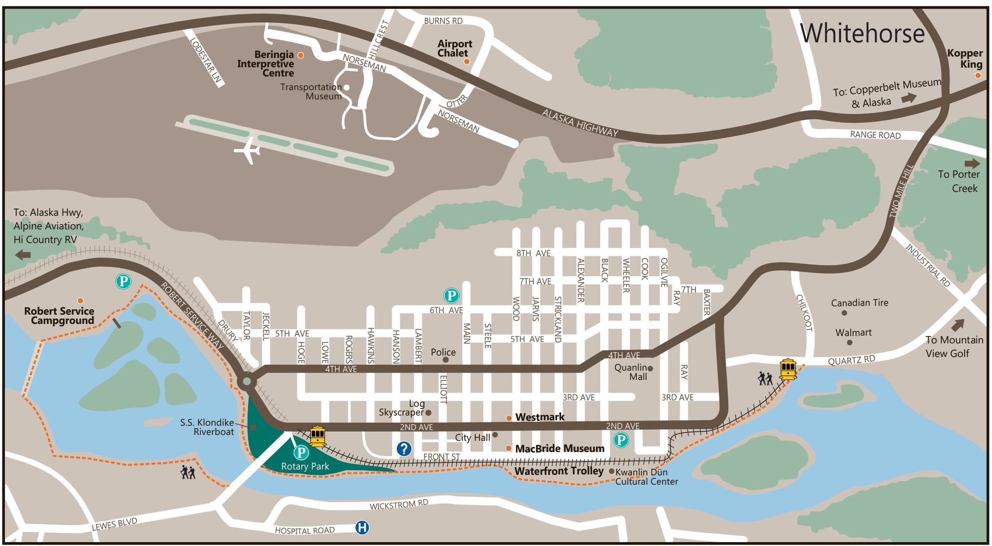
Whitehorse Yukon Map

Whitehorse Yukon FAQS
Is Whitehorse in Alaska or Canada?
Whitehorse is the Capital of the Yukon Territory in Canada. It is located on the Alaska Highway at km 1420. It is 483 south of the Alaska/Yukon border on the Alaska Highway. It is only 137 km north of the Alaska/British Columbia border on the Klondike Highway to Skagway.
What is Whitehorse Yukon Known For?
Whitehorse is known for many things. It played a major role in the 1898 Klondike Gold Rush as a supply center for prospectors and stampeders heading to Dawson City. Now it is the Capital of the Yukon Territory and the largest city in the Yukon.
There is also a large number of activities and things to do in Whitehorse. These include: