The Klondike Highway is 715 km/445 mile highway that connects Skagway Alaska to Whitehorse and Dawson City Yukon, the heart of the Klondike Gold Rush in 1898. The Highway is broken into two sections. The South Klondike from Skagway to Whitehorse and The North Klondike from Whitehorse to Dawson City.
The Klondike Highway roughly parallels the route taken by the prospectors in the 1898 Klondike Gold Rush. It was a grueling journey from Skagway over the Chilkoot Pass or the White Pass to Carcross. From there, prospectors continued by boat or raft along the Yukon River, through Whitehorse to Dawson City.
If you want to plan your own custom Itinerary for the Klondike Highway, try our Free Travel Planner for Alaska and The Yukon.
South Klondike Highway
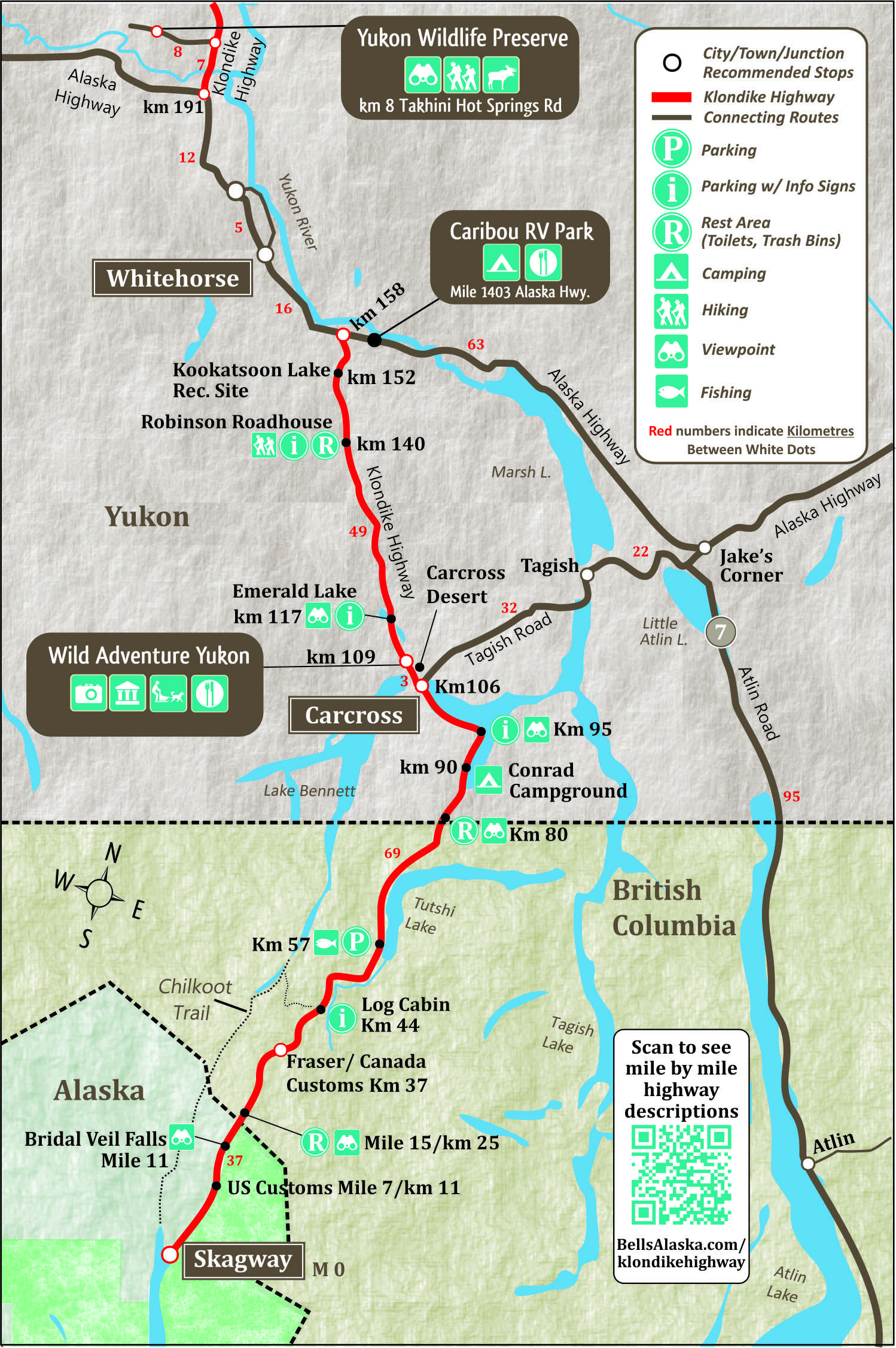
Beginning in Skagway, the South Klondike Highway climbs steeply for 22 km/14 miles to the 3,292 foot/1003 m summit of the White Pass near the Alaska/Canada border. It is 174 km/108 miles from Skagway to Whitehorse.
The last section of the Klondike Highway was built from Skagway to Carcross in 1978 and is now known as the South Klondike Highway. As the highway winds out of Skagway towards Whitehorse you will encounter beautiful lakes and rivers including the stunning Emerald Lake at km 117 (57 km south of Whitehorse).
The South Klondike Highway is part of the Golden Circle Route, a journey that travels from Whitehorse to Skagway, Haines and Haines Junction. Continue on the Ferry from Haines to Juneau and include Alaska’s beautiful capital city on your journey. In 1986 the highway became important as a commercial trucking route, with the abandonment of the White Pass Railroad from Carcross to Whitehorse.
South Klondike Highway Highlights
Wild Adventure Yukon
Wild Adventure Yukon in Carcross offers visitors a complete Yukon experience under one roof. Start with a thrilling dog cart ride led by professional mushers, then explore the wildlife museum featuring the world’s largest polar bear and a life-size woolly mammoth. Visit the RCMP Museum, try your hand at gold panning, and wander through the petting farm with goats, alpacas, and husky puppies. Admission covers all museums, the puppy visit, and the petting farm. On-site café serves sandwiches, soups, and local coffees. Learn more…
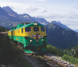
White Pass & Yukon Railway
The White Pass & Yukon Railway in Skagway is one of the most popular attractions in Alaska. Board this historic train and enjoy the journey into the past. The train follows the route that the gold seekers took from Skagway to Carcross, Yukon. Learn more…
Fjord Express to Juneau
Experience the best of Alaska’s Inside Passage in just one day from Skagway or Haines. This spectacular day cruise to Juneau and back includes whale watching, cascading waterfalls, Lynn Canal, a Juneau City Tour and Eldred Rock Lighthouse. Cruise aboard the Fjordland, a state of the art, high speed catamaran. Learn more…


North Klondike Highway
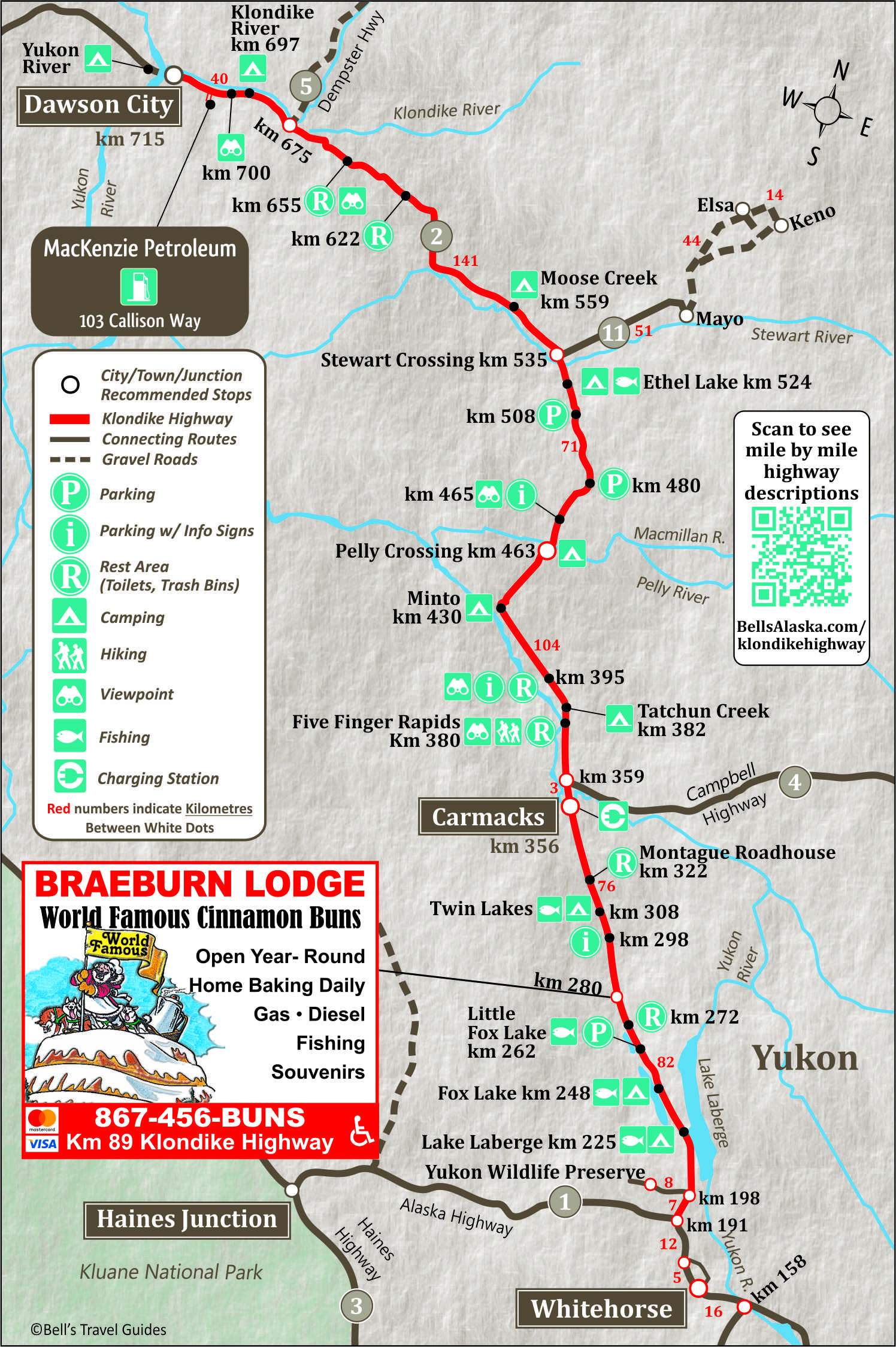
The North Klondike Highway is a further 541 km/336 miles from Whitehorse to Dawson City. The highway starts 12 km north of Whitehorse on the Alaska Highway. Between Whitehorse and Dawson City you will find the communities of Carmacks, Minto, Pelly Crossing, Stewart Crossing and Mayo.
Braeburn Lodge
at km 280. This has been a favorite stop on the way to Dawson City for decades, but was closed in May 2026.
It was famous for it’s enormous cinnamon buns, monster sandwiches, great fishing and souvenirs. 89 km from the Alaska Highway junction.
Carmacks
Carmacks is at the junction of the Klondike Highway and the Robert Campbell Highway, which leads to Faro and Watson Lake. In 1893 George Carmack, who would later discover gold in Dawson, found coal near Five Finger Rapids and went about developing a coal mine.
Carmack built a cabin, which became a trading post and the community of Carmacks was born. It wasn’t long before it became an important riverboat stop between Whitehorse and Dawson City.
The settlement continued to grow when the Overland Trail was routed through Carmacks in 1901. In 1955 a branch road was completed from Carmacks to Dawson. This ended Sternwheeler traffic and resulted in the demise of many small river communities, however, Carmacks was one of the few to survive.
To determine when you should plan your trip to the Yukon and Alaska, visit our page on the best time to visit Alaska.
Finally, many visitors to the Yukon and Alaska want to experience the Northern Lights, so we’ve put together a page of detailed information on how and when to see the Northern Lights.
Fraserway RV Rentals, a Canadian and family-owned company since 1969, are an excellent way to explore the Klondike Highway. Rent an RV in Whitehorse and drive south to Skagway on the South Klondike Highway or Drive north to Dawson City to discover the Klondike.
Pelly Crossing
Pelly Crossing is a small Yukon community along the Klondike Highway, about 73 km (45 miles) north of Carmacks and 201 km (125 miles) south of Dawson City. The community sits on the banks of the Pelly River and is home to the Selkirk First Nation, whose Northern Tutchone heritage is an important part of the area’s history. Visitors can stop at the Big Jonathan House Heritage Centre to learn more about the culture, history, and nearby Fort Selkirk.
For travelers looking to spend the night, Pelly Crossing offers a free riverside campground with scenic views of the Pelly River. The campground includes picnic tables, fire rings, and pit toilets, making it a convenient and budget-friendly stop for those driving the Klondike Highway.
Stewart Crossing
Km 534.8 – Stewart Crossing Junction at north end of bridge. Silver Trail Information Center and rest area at south end of bridge. Stewart Crossing takes its name from the ferry that carried travelers across the Stewart River here from 1950 until a bridge was completed in the mid-1950s. A Yukon government highway maintenance camp and a highway lodge are the main facilities at this small settlement. Highway 11 (the Silver Trail) heads northeast from here to Mayo, Elsa, and Keno City — a worthwhile detour for those interested in Yukon mining history. The road is paved to Mayo and gravel to Keno. This was one of Canada’s richest silver mining areas; the region was widely prospected in the early 1900s, but it was the strike of Louis Bouvette in 1919 that made the area famous.
The Silver Trail — Side Trip off the North Klondike Highway
Highway 11 branches northeast from Stewart Crossing, following the route of one of the Yukon’s most historically rich scenic drives. Allow a full day or more to explore Mayo and Keno City and return to the Klondike Highway.
Mayo
Mayo, 53 km from Stewart Crossing, sits at the confluence of the Mayo and Stewart rivers, within the traditional territory of the Na-Cho Nyak Dun First Nation. The town was established in 1903 as a river settlement and grew into the main service center for the silver, zinc, and lead mining activity in the surrounding hills. Ore was once loaded onto sternwheelers here and shipped south to Whitehorse. Today, Mayo has a population of around 450 and is a convenient base for travelers looking to explore the Silver Trail. You’ll find a motel, restaurants, and local amenities including a grocery store, gas station, and post office. The Binet House Museum and Interpretive Centre shares the community’s mining and river heritage.
Five Mile Lake Campground
Just a few kilometres past Mayo, at km 56.8 of the Silver Trail, Five Mile Lake Campground is a well-maintained Yukon Parks campground with 26 sites, including 3 pull-throughs. The campground has a kitchen shelter and connects to the adjacent Five Mile Lake Recreation Area, which has a boat launch and a sandy beach. Open from early May through the end of September.
Keno City
At the far end of the Silver Trail sits tiny Keno City, km 113, once a booming silver mining town and today a quiet hamlet with far more history than its handful of residents might suggest. Keno Hill was once home to one of the richest silver deposits in the world. The Keno City Mining Museum houses one of the Yukon’s most extensive collections of mining artifacts, photographs, and memorabilia, and the Alpine Interpretive Centre next door explores the area’s wildflowers, birds, and wildlife.
Dawson City
Dawson City, is the heart of the world-famous Klondike Gold Rush of 1898. As many as 60,000 annual visitors come to Dawson, some looking for gold, others to explore it’s rich history. Discover more of Dawson City.
Diamond Tooth Gerties Gambling Hall
Diamond Tooth Gertie’s Gambling Hall is Canada’s first and friendliest casino Gertie’s has been wowing visitors with its unique Klondike period style, nightly cancan entertainment, and friendly charm for decades.
Bonanza Gold RV Park
One mile from Dawson’s city center on the Klondike Highway. Kitchenette, Queen & Double rooms. All rooms have a free Wi-Fi, mini fridge, microwave, coffee maker and air conditioners or fans.
Raven’s Nook
Specializing in unique souvenirs, T-shirts, and sportswear, men’s and ladies fashions and a great selection of footwear make this Dawson City’s mini-Department Store.
Bonanza Market
Fresh meat & locally grown produce, dairy and a complete line of groceries including a fresh Deli with a great selection. 2nd Ave. & Princess St. 867-993-6567
Mackenzie Petroleum
Truck and RV accessible pumps and propane filling service. 103 Callison Way, off the Klondike Highway, 6 km before reaching Dawson City. 867-993-5445
Chief Isaac Mechanical
Specialize in RV, and heavy-duty mechanical repairs. From routine maintenance to tire service, major brake and suspension work and towing. Mobile service available. 867-993-6552

Klondike Highway FAQS
Is the Klondike Highway Paved?
Yes, the entire length of the Klondike Highway is paved, from Skagway to Dawson City. However, there are sections of gravel due to construction between Stewart Crossing and Dawson City.
Can you drive from Skagway to the Yukon?
Yes, you can drive from Skagway to the Yukon on the South Klondike Highway. The South Klondike Highway is the section of the Klondike Highway from Skagway to the Alaska Highway (16 km south of Whitehorse). The North Klondike Highway starts 12 km north of Whitehorse and is 524 km to Dawson City, in the Yukon.
How long is the Klondike Highway?
The Klondike Highway is 715 km from Skagway to Dawson City.
The South Klondike Highway is 158 km from Skagway to the Alaska Highway.
The North Klondike Highway is 524 Km from The Alaska Highway to Dawson City.
There is also a 33 km section between the South and North Klondike Highway that is actually on the Alaska Highway.
How far is Dawson City from Skagway?
Dawson City is 715 km North of Skagway.
Are there fuel stations along the Klondike Highway?
Yes. Fuel is available in the major communities along the Klondike Highway, including Skagway, Carcross, Whitehorse, Carmacks, Pelly Crossing, Stewart Crossing, and Dawson City. Because services can be widely spaced, it’s recommended to top up your fuel tank whenever you pass through a community.
What wildlife can I see along the Klondike Highway?
The Klondike Highway travels through some of the Yukon’s most scenic wilderness, where it’s common to see moose, black bears, grizzly bears, Dall sheep, foxes, caribou, and a variety of bird species. Wildlife is most active around dawn and dusk, so always drive cautiously and observe animals from a safe distance.
Are there campgrounds along the Klondike Highway?
Yes. The Klondike Highway offers numerous Yukon Government campgrounds as well as private RV parks and campgrounds. Many are located beside lakes and rivers, providing convenient overnight stops for travelers exploring the highway.
Is the Klondike Highway open year-round?
Yes. The Klondike Highway remains open throughout the year and is maintained during the winter. However, winter travelers should expect snow, ice, reduced daylight hours, and rapidly changing weather conditions. Winter tires and emergency supplies are strongly recommended.
How many days should I spend driving the Klondike Highway?
Although the highway can be driven in a single long day, most visitors spend two to four days exploring the route. This allows time to enjoy attractions such as White Pass, Emerald Lake, Carcross, Whitehorse, Five Finger Rapids, Tombstone Territorial Park, and historic Dawson City.
Klondike Highway Maps
The two Klondike Highway Maps below, show the highway divided into two sections. The first section shows from Skagway to Carmacks. The second map shows from Carmacks to Dawson City.