The 127 mile/204 km Seward Highway has been designated a National Forest Scenic Byway. It connects the cities ofย Anchorageย to Sewardย traveling past salt water bays, ice-blue glaciers, and alpine valleys. The first 50 miles of the highway twists and turns along the base of the Chugach Mountains, the Chugach National Forest and the shores of Turnagain Arm.
If you want to plan your own custom Itinerary for the Seward Highway,ย try ourย Free Alaska Travel Planner.
Select “Route IN Alaska” and “Anchorage to Kenai Peninsula”ย to get a complete list of accommodations and activities that match your interests.
The 37-foot tides of Turnagain Arm are exceeded only by those in Nova Scotiaโs Bay of Fundy. The waters racing out of the inlet expose miles of mud flats and when they return, frequently create a 6-foot bore tide. These bore tides are highest during the equinox and when a very low tide is followed by a very hightide. If your timing is good, you may even see people surfing or kayaking the bore tide for miles!
Just past the Portage Glacier Road (Mile 79), you will enter the Kenai Peninsula Borough โ over 25,000 square miles of scenic park lands, glaciers, rivers, and unique communities. Here it is easy to try your luck at hooking a world record king salmon or a giant halibut, photograph a Russian church, or view sea lions & whales on a scenic cruise, all on the same day! Mile 79 is also where you will find the Alaska Wildlife Conservation Center.
Most of the Seward Highway passes through the Kenai Mountains-Turnagain Arm National Heritage Area. This heritage area includes mountains, lakes, rivers, fjords and small communities with cultural and historic significance to the nation. The Kenai Mountain-Turnagain Arm National Historic Area stretches from Girdwood to Seward and includes Whittier, Portage, Hope and Cooper Landing.
37 miles north of Seward, the Seward Highway connects with theย Sterling Highwayย which travels southwest to the end of the Kenai Peninsula and accesses the towns ofย Soldotna,ย Kenai,ย Ninilchik,ย Anchor Point, andย Homer.
When you reach Seward, at the end of the highway, you will be met with stunning scenery from this small coastal community. It is known as the gateway toย Kenai Fjords National Parkย and a number of local tour companies will share with you the stunning natural scenery and amazing wildlife found in the park. Visit Kenai Fjords Tours or Major Marine Tours to book an unforgettable adventure.
Youโll get updates on road conditions and construction atย http://511.alaska.gov
The Train From Anchorage to Seward
The Alaska Railroadย parallels the Seward Highway to Portage, where it has a branch line toย Whittier Alaskaย (port for theย Alaska Marine Highway Ferry System and Cruise Port for Anchorage). The Alaska Railroad is also one of the most popular ways to travel from Anchorage to Seward. It is possible to take the Alaska Railroad to Seward for a day trip, but it is recommended you plan to stay at least 1 or 2 days in Seward. The train will arrive in Seward in time for a boat tour of Kenai Fjords National Park, before returning to Anchorage in the evening.
Whittier and Portage
The Portage Glacier Road is at Mile 79 of the Seward Highway. It is 5 miles to Portage and the Begich Boggs Visitor Center. From the parking lot, you will be able to see icebergs floating in Portage Lake. You can no longer see Portage Glacier from the Visitor Center, so we suggest taking a tour with Portage Glacier Cruises, one of the most popular glacier cruise in Alaska.
If you decide to drive the short distance into town of Whittier, you will pass through the Anton Anderson Memorial Tunnel. At 2.5 miles, this is the longest tunnel in North America that allows both trains and vehicles to share the tunnel. Thankfully, on an alternating schedule!
Whittier is known as a gateway to Prince William Sound, with is beautiful protected waters, stunning glaciers and incredible marine wildlife viewing. There are a number of glacier cruises and boat tours in Whittier that will take visitors out to experience this natural wonder. Be sure to check out Lazy Otter Charters in Whittier.
Warning:ย The mudflats along the coast from Anchorage to Portage (Turnagain Arm) exhibit quicksand-like conditions. It is extremely dangerous to walk on the beach or mudflats in this area.
For a complete list of Things to do in Alaska, visit ourย Things To Do section. For information on places to camp, visit our section onย camping in Alaska. To determine when you should plan your trip to Alaska, visit our page on theย best time to visit Alaska. Finally, many visitors to the north want to experience the Northern Lights, so weโve put together a page of detailed information on how and when to see theย Northern Lights.
Top 10 Scenic Stops on the Seward Highway
The Seward Highway packs more scenery per mile than almost any road in North America. Designated a National Scenic Byway and an All-American Road, it threads through the Chugach Mountains, hugs the edge of Turnagain Arm, crosses into the Kenai Mountains, and ends at a dramatic fjord-lined harbor. Here are the ten stops that define the drive โ pull over, breathe it in, and take your time.
Potter Marsh Bird Sanctuary โ Mile 117
The drive begins (or ends) with one of Anchorage’s best-kept secrets. Potter Marsh is a 460-acre wetland that sits right at the edge of the highway and serves as a critical nesting ground for migrating waterfowl. A free, paved boardwalk extends out over the marsh, giving visitors eye-level views of Arctic terns, trumpeter swans, Canada geese, and the occasional sandhill crane. In late summer, watch for spawning salmon in the channels below the walkway.
โข Why stop here: Free wildlife viewing right off the highway with zero hiking required
โข Time needed: 20โ45 minutes
โข Parking: Large dedicated lot on the highway shoulder
โข Best season: MayโSeptember (peak bird activity MayโJune)
Beluga Point โ Mile 110.3
Beluga Point viewpoint sits directly above Turnagain Arm, offering sweeping, unobstructed views of the water and the wall of Chugach peaks on the far shore. As the name promises, beluga whales regularly appear here from mid-July through August, swimming in loose pods that follow the salmon runs. The parking area features interpretive signs, a beluga sculpture, and coin-operated telescopes โ though binoculars of your own are even better.
โข Why stop here: Best chance on the highway to spot beluga whales from land
โข Time needed: 20โ40 minutes
โข Parking: Paved lot with room for RVs
โข Pro tip: Arrive 1โ2 hours before high tide for the best whale activity
Windy Corner โ Mile 106.8
If Beluga Point is famous for sea mammals, Windy Corner is famous for mountain mammals. The sheer rock faces that press right against the highway here are prime Dall sheep habitat, and the white woolly animals are spotted here more consistently than anywhere else along the Seward corridor. Rams, ewes, and lambs pick their way along ledges just meters above the road, seemingly unbothered by passing traffic. This is also a favorite spot for bald eagles hunting the fish runs in Turnagain Arm below.
โข Why stop here: Dall sheep โ often visible from the car window
โข Time needed: 10โ20 minutes
โข Parking: Small pullout โ use the nearest safe shoulder if full
โข Safety note: Never approach sheep on foot; they can move to the road unexpectedly
Bird Point โ Mile 96.5
Bird Point is one of the best spots on the entire highway to witness the Turnagain Arm bore tide โ a natural phenomenon where the incoming ocean tide funnels into the narrowing inlet and creates a visible wave that travels up the Arm. On the right day (check the tide tables before you leave Anchorage), you can stand at Bird Point and watch a rolling wall of water move past at 10โ15 mph. The viewpoint also connects to the paved Bird to Girdwood Trail, a popular 6-mile multi-use path through coastal forest.
โข Why stop here: Best roadside bore tide viewing on the highway
โข Time needed: 30โ60 minutes (longer if watching bore tide)
โข Parking: Large paved lot with restroom facilities
โข Pro tip: Check tidesandcurrents.noaa.gov for Turnagain Arm tide times and plan accordingly
Girdwood & Alyeska Resort โ Mile 90
Girdwood is a true gem visitors donโt want to miss. The village sits in a valley surrounded by hanging glaciers and spruce-covered peaks, with a vibrant community of artists, outdoor athletes, and longtime Alaskans. The centerpiece is Alyeska Resort, whose aerial tram transports visitors 2,300 feet up Mount Alyeska to panoramic views of the Chugach peaks, Cook Inlet, and Turnagain Arm. In summer, wildflowers carpet the upper slopes. The roundtrip tram ride takes about 30 minutes and is one of the most accessible alpine experiences in Alaska. There is also a high-end restaurant located at the top of the Tram.
โข Why stop here: Only alpine tram on the Kenai Peninsula + dining and shops in the village
โข Time needed: 1.5โ3 hours
โข Parking: Large free lot at Alyeska Resort base
โข Don’t miss: The Bake Shop in the village โ a local institution for decades
Alaska Wildlife Conservation Center โ Mile 79
Set against the dramatic backdrop of the Chugach Mountains and Portage Valley, the Alaska Wildlife Conservation Center is one of the best places in the state to see Alaska’s iconic wildlife up close. The 200-acre sanctuary rehabilitates injured and orphaned animals, and its residents include brown and black bears, muskox, wood bison, moose, wolves, and wolverines โ all in spacious naturalistic habitats. Unlike a zoo, the AWCC sits right in wild Alaska, so the combination of captive animals and stunning mountain scenery is genuinely special.
โข Why stop here: Best guaranteed large wildlife viewing on the entire corridor
โข Time needed: 1.5โ2.5 hours
โข Parking: Large dedicated lot; admission charged
โข Good for: Families with children, photographers, first-time Alaska visitors
Portage Glacier & Begich Boggs Visitor Center โ Mile 79
Just past the AWCC, the Portage Glacier Highway branches off 5 miles to The Begich Boggs Visitor Center sits at the edge of Portage Lake, where icebergs calved from the glacier drift silently in turquoise water. Portage Glacier itself has retreated significantly and is no longer visible from the center, but a boat tour with Portage Glacier Cruises brings you right to the ice face โ one of the most dramatic glacier experiences accessible by road in Alaska. Even without the tour, the floating icebergs and mountain backdrop make the 5-mile detour worthwhile. The Portage Glacier Highway continues another 6 miles to Whittier, which is accessed via the Anton Anderson Memorial Tunnel, the longest combined road/rail tunnel in North America.
โข Why stop here: Floating icebergs and the most accessible glacier cruise in Alaska
โข Time needed: 1โ3 hours (longer with glacier cruise)
โข Parking: Large lot at visitor center; cruises depart from adjacent dock
โข Pro tip: Book the Portage Glacier Cruise in advance in peak summer โ it fills up
Tern Lake Junction โ Mile 37
Where the Seward Highway meets the Sterling Highway, Tern Lake sits in a broad mountain valley that feels like the geographic heart of the Kenai Peninsula. Arctic terns nest and fish the shallow lake through summer, diving for fish with precision that makes it fun and interesting to watch. Trumpeter swans, loons, and beavers are also regulars here. The lake is easily visible from the road and a short gravel path reaches the shoreline. This is also a classic wildlife photography spot โ the surrounding mountains form a perfect backdrop.
โข Why stop here: Arctic terns, swans, and mountain reflections in a classic Kenai valley
โข Time needed: 15โ30 minutes
โข Parking: Gravel pullout at the junction; also a picnic area nearby
Moose Pass โ Mile 29
Moose Pass is a blink-and-you’ll-miss-it community of around 200 people that has been here since the early railroad days. It sits in a narrow valley between Trail Lake and Kenai Lake, with the mountains pressing in on all sides. The town holds an annual summer solstice festival with fiddle music, games, and a real small-Alaska-town charm. For hikers, the trailheads for Johnson Pass, Carter Lake, and Ptarmigan Creek are all within a short distance. Even if you don’t hike, the scenic valley and the mirror-like lakes make a worthwhile stop.
โข Why stop here: Authentic small-town Alaska atmosphere + excellent hike access
โข Time needed: 20โ30 minutes (or all day if hiking)
โข Facilities: Lodge with restaurant, fuel, gift shop
Exit Glacier โ Mile 3.5 (Herman Leirer Road)
The final highlight before rolling into Seward is the only road-accessible section of Kenai Fjords National Park. Drive 8.4 miles down Herman Leirer Road, known locally as โExit Glacier Roadโ to reach the nature center and trailhead. A short walk brings you to the snout of Exit Glacier โ a river of ancient ice creeping down from the Harding Icefield above. Interpretive signs mark how far the glacier extended in past decades, making the pace of retreat strikingly visible. A longer hike to the Harding Icefield overlook is one of the most spectacular day hikes in the state, though it requires solid fitness and 8โ10 hours.
โข Why stop here: Only road-accessible glacier in Kenai Fjords National Park
โข Time needed: 1โ2 hours (short trail); full day for Harding Icefield hike
โข Parking: Large NPS lot with vault toilets and nature center (summer hours)
โข Note: The road is closed in winter; check nps.gov/kefj for seasonal access dates
Driving Conditions & Safety Check
What Drivers Should Know Before They Go
The Seward Highway is one of Alaska’s most scenic drives โ and one of its most important to drive carefully. It is a two-lane National Scenic Byway that passes through tidal flats, mountain passes, and unpredictable coastal weather systems. Here is what everyone should know before setting out.
Road Layout
โข Two-lane highway with frequent passing lanes in both directions
โข Paved, well-maintained shoulders for most of the route โ good for pulling over safely
โข Some sections between Girdwood and Portage have limited shoulder width โ use designated pullouts only
โข Speed limit varies: generally 55 mph with reductions through Girdwood and near trailheads
Summer Driving
โข Weekend summer traffic from Anchorage can be heavy, particularly on Friday afternoons and Sunday evenings โ avoid these windows if possible
โข Keep headlights on at all times.
โข Sudden coastal fog can roll in over Turnagain Arm without warning, especially mornings
โข Wildlife crossing zones are active all summer โ moose, Dall sheep, and black bears can appear on the road
โข Do not stop in travel lanes to photograph wildlife โ use designated pullouts
Winter Driving
โข The Turnagain Arm corridor (Anchorage to Portage) is an active avalanche zone in winter โ the Alaska DOT has avalanche cannons in the area and may close the highway after major snowfall
โข Ice forms quickly in shaded sections, particularly on curves โ drive for conditions, not the speed limit
โข Studded tires or snow rated all-season tires recommended from October through April
โข Always check 511.alaska.gov before departure in winter for closures, conditions, and construction
โข Carry an emergency kit: water, extra layers, flashlight, jumper cables, and traction aids
Mudflat Warning
The mudflats along Turnagain Arm between Anchorage and Portage look walkable but are not. The glacial silt acts like quicksand โ people have become trapped and been unable to free themselves before the tide returned. Do not walk on the mudflats under any circumstances. This is not a local exaggeration; multiple fatalities and near-fatalities have occurred on these flats.
Pacing the Drive
โข Allow 5โ8 hours for a one-way drive with proper stops โ this is not a road to rush.
โข Fuel is available in Anchorage, Girdwood, and Seward โ there are no gas stations between Portage and the Seward outskirts (roughly 90 miles)
โข Cell service is unreliable from Girdwood through the Kenai Mountains โ download offline maps before you leave or pick up a copy of Bellโs Alaska Mapbook at local visitor centers.
โข Restrooms available at Bird Point, the AWCC, Begich Boggs Visitor Center, and Exit Glacier
Side Trips From the Seward Highway
One of the great strengths of the Seward Highway is that it connects to a remarkable network of side roads and detours, each worth an entire day of exploration on its own. If you have extra time, consider adding one or more of these to your itinerary.
Alyeska Resort & Girdwood Village โ Mile 90
The Alyeska Road at Mile 90 leads 3 miles into the Girdwood Valley, where Alaska’s premier ski resort sits beneath hanging glaciers year-round. In summer the resort pivots to hiking, mountain biking, and sightseeing, with the aerial tram running to the 2,300-foot summit of Mount Alyeska. The Seven Glaciers Restaurant at the top of the tram offers one of the most dramatic fine dining settings in Alaska. The village of Girdwood itself has grown into a lively community with excellent restaurants, craft beer, art galleries, and a small grocery.
โข Detour distance: 3 miles from highway to resort base
โข Don’t miss: Alyeska Aerial Tram in summer for alpine wildflower meadows and panoramic views
โข Best for: Scenic tram ride, hiking, dining, mountain biking, and a break from driving
โข Fuel: Available in Girdwood โ last fuel stop for roughly 90 miles until Seward
Whittier & Prince William Sound โ Mile 79 (Portage Glacier Highway)
At Mile 79, the Portage Glacier Highway branches east. After 5 miles you reach Portage, and from there the Anton Anderson Memorial Tunnel carries vehicles (and trains, on alternating schedules) 2.5 miles through the mountain into Whittier โ the longest tunnel in North America shared by rail and road traffic.
Whittier itself is a tiny, fascinating community of fewer than 300 permanent residents, many of whom live in a single 14-story concrete high-rise (Begich Towers) that contains a post office, clinic, and church. But the real draw is what lies beyond the harbor: Prince William Sound, with its protected waters, tidewater glaciers, sea otters, orcas, sea lions, and thousands of seabirds. Glacier and wildlife cruises depart Whittier harbor throughout summer, and the paddling is world-class for sea kayakers. Whittier is also the closest port to Anchorage and the departure/disembarkation point for many Alaska Cruises.
โข Detour distance: 11 miles from Seward Highway to Whittier (plus tunnel wait time)
โข Tunnel fee: Charged each way; check alyeskatunnel.com for current tolls and schedule
โข Don’t miss: Lazy Otter Charters for Prince William Sound glacier and wildlife tours
โข Best for: Glacier cruising, sea kayaking, photography, marine wildlife
Hope โ Mile 56 (Hope Highway)
The 16-mile Hope Highway branches north at Mile 56.7 of the Seward Highway, climbing through birch and spruce forest to the historic gold rush town of Hope on the south shore of Turnagain Arm. Hope predates Anchorage โ it was founded in 1896 after gold was discovered in the creek beds โ and its weathered buildings, old cemetery, and quiet streets give it a genuinely frontier feel. The population hovers around 200, and the community has resisted the tourist commercialism that defines many Alaska towns.
Near the start of the Hope Highway, the Chugach Outdoor Center runs whitewater rafting trips on the Sixmile Creek โ some of the most thrilling Class IVโV commercial rafting in Alaska. Hope itself has a small general store, a bar, camping, and access to the Resurrection Pass Trail, one of the finest multi-day backpacking routes on the Kenai Peninsula.
โข Detour distance: 16 miles one way from the highway
โข Don’t miss: Chugach Outdoor Center rafting on Sixmile Creek
โข Best for: History, rafting, backpacking access (Resurrection Pass Trail), photography
โข Facilities: Small general store, camping, no fuel โ fill up before turning off
Sterling Highway & the Kenai Peninsula โ Mile 37
At Tern Lake Junction (Mile 37), the Sterling Highway splits west toward the rest of the Kenai Peninsula. This opens up an entirely separate multi-day road trip extending to Cooper Landing (world-class salmon fishing on the Kenai River), Soldotna, Kenai, Ninilchik, Anchor Point, and finally Homer โ the end of Alaska’s road system on Kachemak Bay. The Homer Spit, with its halibut charter fleet and unique harbor culture, is one of the most beloved destinations in the state. A Seward Highway trip can easily be extended into a week-long loop combining both highways.
โข Key destinations: Cooper Landing, Soldotna, Kenai, Homer
โข Best for: Salmon fishing, halibut charters, small-town Alaska, the Homer Spit
Distance from Tern Lake to Homer: approximately 135 miles
Kenai Fjords Boat Tours โ Seward Harbor (Mile 0)
Once you reach Seward, the highway ends but the adventure doesn’t. Seward is the launching point for some of the best wildlife and glacier boat tours in all of Alaska. From the small boat harbor, multiple operators run half-day and full-day cruises into Kenai Fjords National Park โ past tidewater glaciers that calve thunderously into the sea, through waters thick with humpback whales, orcas, Steller sea lions, Dall’s porpoise, and tens of thousands of seabirds. The full-day tour to the Northwestern Fjord is considered one of the bucket-list wildlife experiences in North America.
โข Operators: Major Marine Tours, Kenai Fjords Tours (book well in advance for summer)
โข Best for: Glaciers, marine wildlife, seabirds, bucket-list experiences
โข Pro tip: The full-day Northwestern Fjord cruise is the standout choice if time allows
Seward Highway Driving Highlights
Mile markers for the Seward Highway start at the very beginning of downtown Seward (Mile 0), near the Alaska SeaLife Center and end in Downtown Anchorage (Mile 127). You will reach the outskirts of Anchorage at Mile 120. Most people driving the Highway from Anchorage to Seward for the first time will be driving to Seward so the mile markers will count down to mile 0.
Beluga Point Lookout (Mile 110.3).
Beluga Point is a popular stopping point on the drive from Anchorage to Seward. It got it’s name because of the large number of Beluga Whales that are commonly spotted in the area. There are over 300 Beluga Whales that inhabit Cook Inlet and Turnagain Arm from mid-July to August.
The viewpoint at Beluga point has spectacular, uninterrupted views of Turnagain Arm, where you may also spot Bald Eagles soaring overhead in search of salmon. The parking lot has information signs, a beluga sculpture and telescopes for spotting the whales in the distance.
Windy Corner (Mile 106.8).
Windy corner is known as one of the best places to spot Dall Sheep in all of Alaska. The high rock faces at the edge of the road are often full of sheep, perched in precarious spots along the cliff walls, grazing. Occasionally, the sheep will come all the way down to the side of the road. If you do spot Dall sheep, pull over at the nearest pullout.
Bird Creek Campground (Mile 100.8).
This campground is in the Chugach State Park and has 22 sites for RVs and tents. It connects with the paved, multi use trail to Girdwood. There is water, picnic tables and toilets.
Bird Point (Mile 96.5).
Bird Point is another great place to stop and enjoy the views over Turnagain Arm. Watch for Beluga Whales out in the water. They tend to come in with the tide to feed on the salmon, so a few hours before high tide is your best chance of spotting them. There is also a paved, multi use trail that connects to Girdwood, 6 miles south. This is also one of the best places to watch the bore tide. You can check the tide schedule to determine the best time to view this amazing natural phenomenon.
Alyeska Resort and Tram (In Girdwood at Mile 90)
The Tram at Alyeska Resort is short ride to a viewing deck at 2300 ft. With breathtaking panoramic views of mountains, hanging glaciers and an abundance of wildlife. In the Summer months Alyeska is a destination for its scenic vistas, while in the winter the Alyeska Ski Resort is most developed ski resort in all of Alaska.
The Alaska Wildlife Conservation Center (at Mile 79)
AWCC is a non-profit sanctuary dedicated to preserving Alaskaโs wildlife through conservation, education and research. The sanctuary maintains over 200 acres of spacious habitats for resident animals to feel at home displaying their natural wild behavior as education ambassadors for their species. It is common for visitors to see black bears, brown bears, moose, wood bison, muskox, wolves, porcupines, and more.
Hope Alaska (Mile 56)
At mile 56, take the 16 mile road toย Hopeย and discover one of Alaskaโs oldest gold rush towns.
Moose Pass (Mile 29)
Moose Pass is a small community of 300 on the Seward Highway. It is a haven for outdoor enthusiasts who love hiking and backpacking. It is near Johnson Pass Trail, Carter Lake Trail, Victor Creek Trail and Ptarmigan Creek Trail. Moose Pass has a lodge with a restaurant and gift shop.ย
Exit Glacier (Mile 3.5)
Turn on Herman Leirer Road (Also known as Exit Glacier Road). Drive 8.4 miles to Exit Glacier, which is the only part of the Kenai Fjords National Park that is accessible by car. You can also stay near Exit Glacier at theย Seward KOA Campground.
If you are looking for Glacier Ice Caves to explore, here are someย ice caves near Seward highway.
Seward Alaska (Mile 0)
Hotels & Camping
Things To Do
Frequently Asked Questions about the Seward Highway
How long does it take to drive the Seward Highway?
Without stops, the Seward Highway takes approximately 2.5 to 3 hours to drive from downtown Anchorage to Seward. However, with scenic pullouts, wildlife viewing, and stops at places like Beluga Point, the Alaska Wildlife Conservation Center, and Exit Glacier, most travelers spend 5โ8 hours making the full journey. Plan for a full day if you want to experience the highway properly rather than just transit it.
Is the Seward Highway dangerous in winter?
The Seward Highway can be hazardous in winter, particularly between Anchorage and Girdwood along Turnagain Arm. This section is prone to avalanche activity, ice patches, and rapidly changing weather. The Alaska Department of Transportation occasionally closes segments temporarily after significant snowfall or avalanche events. If you’re driving in winter, check 511.alaska.gov before you leave, carry emergency supplies, and consider all-season or studded tires. The section from Portage to Seward through the Kenai Mountains can also be slippery and have reduced visibility in storms.
Can you see glaciers from the road?
Yes โ glaciers are visible from the Seward Highway in several places. Hanging glaciers cling to the faces of the Chugach Mountains visible from the Turnagain Arm section of the road. The most dramatic close-up glacier experience requires short detours: Portage Glacier Road (5 miles off the highway at Mile 79) brings you to an iceberg-filled lake and glacier cruise access, and Exit Glacier Road (at Mile 3.5) leads to the only drive-in section of Kenai Fjords National Park, where you can walk right up to active glacial ice.
Where are the best stops on the Seward Highway?
The top stops on the Seward Highway are: Potter Marsh (Mile 117) for bird watching, Beluga Point (Mile 110.3) for whale spotting and Turnagain Arm views, Windy Corner (Mile 106.8) for Dall sheep, Bird Point (Mile 96.5) for bore tide viewing, Girdwood/Alyeska (Mile 90) for the aerial tram and village amenities, the Alaska Wildlife Conservation Center (Mile 79) for guaranteed large wildlife viewing, Portage Glacier (Mile 79) for icebergs and glacier cruises, Tern Lake (Mile 37) for birds and mountain reflections, and Exit Glacier (Mile 3.5) for a walk-up glacier experience in Kenai Fjords National Park.
Is the Seward Highway paved the entire way?
Yes, the Seward Highway is fully paved for its entire 127-mile length from Anchorage to Seward. It is a two-lane highway with passing lanes in many sections and paved shoulders for most of the route, making it one of the most comfortable highway drives in Alaska. Standard vehicles handle it easily in good weather. The short detour roads to Portage Glacier (5 miles) and Exit Glacier (8.4 miles) are also paved.
When is the best time to drive the Seward Highway?
The Seward Highway is open year-round, but the best driving experience is from late May through early September. During this window, daylight is long (up to 19+ hours in June), wildflowers are in bloom, beluga whales appear in Turnagain Arm from mid-July through August, and all highway services are operational. June and July offer the most reliable weather and the longest days. September is also excellent โ fall colors appear on the hillsides and crowds thin out. Winter driving is possible but requires preparation for ice, avalanche closures, and reduced daylight.
How long is the drive from Anchorage to Seward
The drive from Anchorage to Seward is 127 miles but Itโs actually only 119 miles to reach the southern outskirts of Anchorage. the last 8 miles of the Seward Highway double as one of the main traffic arteries of the city of Anchorage.
Is the Seward Highway Paved
Yes the Seward Highway is Paved the entire way. There are also plenty of passing lanes in both directions, making it one of the easiest highways in Alaska to drive. It has wide paved shoulders for most of the way as well.
What is the best way to get from Seward to Anchorage?
The two most common ways to get from Seward to Anchorage are by car or on the Alaska Railroad. Many visitors arrive in Seward by cruise ship and decide to travel to Anchorage and Denali National Park. The drive is easy and if you donโt have your own vehicle, you can rent fromย Hertz in Seward. They offer one way rentals between Seward and Anchorage.ย
The Alaska Railroad is also a very easy way to get from Seward to Anchorage. The train leaves everyday during the summer. The train parallels the Seward Highway at times, but also takes a slightly different route that offers spectacular scenery. You can stop in Portage and take the train to Whittier or Spencer Glacier.
Is Seward worth visiting?
Yes, absolutely Seward Alaska is worth visiting. It is one of the most beautiful cities in Alaska. It is also the gateway to the Kenai Fjords National Park. You can hike on a glacier, atย Exit Glacier, which is a very Alaskan activity.
Can I get from Seward to Anchorage without a car?
Yes, the Alaska Railroad is a great way to get from Seward to Anchorage if you donโt want to drive. There are also coach service during the summer with the Park Connection Motorcoach.
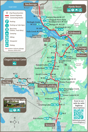
Seward Highway Map
The map of the Seward Highway shows the abundant recreation areas along the highway. Between Anchorage and Girdwood there are dozens of scenic viewpoints overlooking Turnagain Arm. At Girdwood, you can take the short side trip up to the Alyeska Resort and Aerial Tram.ย
Only 11 miles further south on the Seward Highway is Portage Recreation Area. This is also where you will find theย Alaska Wildlife Conservation Center, one of the best opportunities to view wildlife in Alaska.
At Portage, you can turn off the Highway and and drive to Whittier via two tunnels. The Whittier tunnel is the 2nd longest in North America.
After Portage and Whittier, the next worthwhile side trip is the road toย Hopeย at mile 56. Hope is a former gold rush town and existed even before Anchorage was founded. The Hope road is also where you will findย Chugach Outdoor Center, a premier rafting company sure to give you a thrill.


